Benicia–Martinez Bridge
| Benicia–Martinez Bridge | |
|---|---|
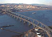 Aerial view of the Benicia–Martinez Bridge. From left to right: Southbound span (1962) Railway (1930) and Northbound span (2007) | |
| Coordinates | 38°02′26″N 122°07′23″W / 38.0406°N 122.1230°WCoordinates: 38°02′26″N 122°07′23″W / 38.0406°N 122.1230°W |
| Carries |
9 lanes of |
| Crosses | Carquinez Strait |
| Locale | Martinez and Benicia, California, U.S. |
| Official name | George Miller, Jr., Memorial Bridge[2] (southbound span), Congressman George Miller Benicia–Martinez Bridge[2] (northbound span) |
| Owner | Caltrans |
| Maintained by | Caltrans and the Bay Area Toll Authority |
| ID number | 28 0153 |
| Characteristics | |
| Design | Truss bridge (southbound span), segmental bridge (northbound span), Lift bridge (railroad bridge) |
| Total length | 1.7 miles (2.72 km, 8,976 feet) |
| Longest span | 528 feet (0.1 mi) (7 spans) |
| Clearance below | 138 feet (42.1 m) |
| History | |
| Opened | 1962/2007 |
| Statistics | |
| Toll |
Cars (northbound only) $5.00 (cash or FasTrak), $2.50 (carpools during peak hours, FasTrak only) |
The Benicia–Martinez Bridge refers to three parallel bridges which cross the Carquinez Strait just west of Suisun Bay; the spans link Benicia, California on the north side with Martinez, California on the south.
The original 1.2-mile (1.9 km) deck truss bridge opened in 1962 to replace the last automotive ferry service in the San Francisco Bay Area. The 1962 bridge has seven 528-foot (161 m) spans and 138 feet (42 m) of vertical clearance, now carrying four lanes of southbound traffic, as well as a path for pedestrians and bicyclists.[1] It was named the George Miller, Jr., Memorial Bridge in 1975 after George Miller, Jr.[2] A 1.7-mile (2.7 km) bridge was built alongside and opened on August 25, 2007 with five lanes of northbound traffic. In 2007, it was named the Congressman George Miller Benicia–Martinez Bridge after George Miller, Miller Jr.'s son.[2] The cost of the 1962 span was US$25 million and US$1.3 billion for the 2007 span.[3] The bridge is part of Interstate 680, major transportation link, and connects other heavily traveled freeways.
Between the two vehicle bridges is a Union Pacific Railroad bridge, the first bridge at this location, built between April 1929 and October 1930 by Southern Pacific. It is used by Union Pacific and BNSF (trackage rights) freight trains and 36 scheduled Amtrak passenger trains each weekday. Passenger trains include the long-distance trains California Zephyr and Coast Starlight and short-haul Capitol Corridor trains.
Tolling
Tolls are only collected from northbound traffic at the toll plaza on the south side of the bridge. Since July 2010, the toll rate for passenger cars is $5. During peak traffic hours, carpool vehicles carrying three[4] or more people or motorcycles pay a discounted toll of $2.50.[5][6] For vehicles with more than two axles, the toll rate is $5 per axle.[7] Drivers may either pay by cash or use the FasTrak electronic toll collection device. Credit cards are not accepted for payment.
The toll plaza has nine lanes with toll booths and another nine lanes with open road tolling (ORT) in two zones. One ORT zone has two travel lanes and four shoulder lanes. The other ORT zone has one carpool travel lane with two shoulder lanes. This bridge is the first open road tolling facility in Northern California and the first bridge with open road tolling in California.
Railroad bridge
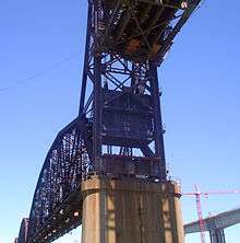
Union Pacific Railroad's Benicia-Martinez drawbridge is between the two vehicle bridges. The railroad bridge was built between 1928 and 1930 for Southern Pacific Railroad to replace its train ferry between Benicia and Port Costa, California. It is the second-longest railway bridge in North America, and the longest railway bridge west of the Mississippi River. Before the bridge was completed, ferries were used to allow the railway to cross Suisun Bay. The original ferry, built at Oakland, California in 1879 and named the Solano, was the world's largest train ferry. In 1914 the larger Contra Costa was built. In 1926 the ferries carried 93,000 passenger cars and 142,000 freight cars across the Strait.[8]
Ferry service ended in 1930 with the completion of the railroad bridge. Burlington Northern and Santa Fe Railway and Amtrak also run here on trackage rights. The drawbridge has the smallest clearances of the three bridges — lift span horizontal clearance is 291 feet and vertical clearances are 70 feet (closed) and 135 feet (open).
Northbound span
In late 2001, construction began on a newer bridge east of and parallel to the railroad bridge. It measures about 1.7 miles (2.7 km). The new bridge carries five lanes of northbound traffic. The older bridge underwent seismic retrofits and now carries four lanes of southbound traffic and a bicycle/pedestrian lane, part of the San Francisco Bay Trail. The bridge construction included a new toll plaza with nine toll booths, two open road tolling lanes and one carpool lane at the south end of the bridge, although tolls continue to be charged only for northbound traffic.
The new toll plaza was retrofitted for open road tolling to encourage FasTrak use. This required the removal of eight toll booths.
The bridge is the largest lightweight concrete segmental bridge in California. The estimated cost was $1.05 billion, the final cost was $1.3 billion. The original estimated cost was around $300 million, it is noted for its large delay in construction and large over cost (over $1 billion). The project's cost overshadowed the replacement of the Cypress Freeway portion of Interstate 880. The new bridge opened at 10:30pm on August 25, 2007.[9][10]
Vista point
A vista point is located on the north side of the span, providing an excellent view of the 3 parallel bridges passing over the Carquinez Strait with Mount Diablo in the background. It has ample parking, picnic tables and a large compass to provide orientation. This is typically the point where cyclists and pedestrians wishing to cross the bridge park their cars.[11]

See also
- California Pacific Railroad
- Carquinez Bridge
-
 Bridges portal
 -
 California portal
 -
 San Francisco Bay Area portal
References
- 1 2 "New Lanes to Open on Southbound Benicia-Martinez Bridge" (PDF) (Press release). Caltrans. 2009-07-29. Retrieved 2009-08-18.
- 1 2 3 4 "Assembly Concurrent Resolution No. 62". California State Legislature. 2007-07-05. Retrieved 2009-08-18.
- ↑ "Bay Area's newest bridge is open for business". 2007-08-26. Retrieved 2007-08-27.
- ↑ https://www.bayareafastrak.org/static/facilities/benicia.shtml
- ↑ "Frequently Asked Toll Questions". Bay Area Toll Authority. 2010-06-01. Archived from the original on 2010-11-01. Retrieved 2010-06-29.
- ↑ "Toll Increase Information". Bay Area Toll Authority. 2010-06-01. Archived from the original on 2010-11-01. Retrieved 2010-06-29.
- ↑ "Toll Increase Information: Multi-Axle Vehicles". Bay Area Toll Authority. 2012-07-01. Retrieved 2013-12-29.
- ↑ Railway Age 9 March 1929 p576
- ↑ "The Benicia Bridge". Vallejo Times Herald. 2007-08-25. Retrieved 2007-08-25.
- ↑ "First cars drive over new Benicia Bridge". San Jose Mercury News. 2007-08-25. Retrieved 2007-09-03.
- ↑ http://www.solanoopenspace.org/OtherOutdoor_BeniciaBridgeVista.asp
External links
- California Dept. of Transportation: Benicia–Martinez Bridge History & Information
- Caltrans' New Benicia–Martinez Bridge project page
- Earth Mechanics Inc. Benicia bridge project page - geotechnical engineer for the new bridge
- Benicia–Martinez Bridge may cost millions more - Contra Costa Times article about technical difficulties
- Benicia–Martinez Bridge (1962) at Structurae
- Benicia Martinez Bridge (2007) at Structurae
| Crossings of the Carquinez Strait | ||||
|---|---|---|---|---|
| ||||
| Bodies of water |
|  |
|---|---|---|
| Counties | ||
| Major cities | ||
| Cities and towns 100k–250k | ||
| Cities and towns 50k–99k | ||
| Cities and towns 25k-50k | ||
| Cities and towns 10k–25k |
| |
| Sub-regions | ||