Ben Sawyer Bridge
| Ben Sawyer Bridge | |
|---|---|
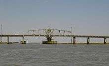 The Ben Sawyer Bridge in 2008, with its original swing-span section | |
| Coordinates | 32°46′23″N 79°50′32″W / 32.77306°N 79.84222°WCoordinates: 32°46′23″N 79°50′32″W / 32.77306°N 79.84222°W |
| Carries |
|
| Crosses | Intracoastal Waterway |
| Locale | Mount Pleasant – Sullivans Island, South Carolina, United States |
| Official name | Ben Sawyer Bridge |
| Maintained by | South Carolina Department of Transportation |
| Characteristics | |
| Design | Movable swing |
| Total length | 1153 feet (351.7 m) |
| Width | 40 feet (12 m) (old span: 26 feet (7.9 m)) |
| Longest span | 246 feet (75 m)[1] |
| Load limit | 20 tons (18 metric tons) |
| Clearance above | 32 feet (9.8m) (closed) |
| History | |
| Opened | 1945 |
| Statistics | |
| Daily traffic | 12,400 (2005) |
The Ben Sawyer Bridge is a swing bridge that connects the town of Mount Pleasant with Sullivan's Island in South Carolina. The bridge swings on its central axis to open for boat traffic which is too tall to clear the bridge, and has an operator's house in the center of the swing span from which an tender can operate the bridge. The bridge was originally constructed in 1945,[1][2] but the steel superstructure for the approach spans and swing span was replaced in 2010, albeit retaining the same general appearance.
Prior to completion of the Isle of Palms Connector Bridge in 1993, the Ben Sawyer Bridge provided the only vehicular access to Sullivan's Island, and, by a connecting bridge, Isle of Palms.[2]
The bridge was heavily damaged during Hurricane Hugo, leaving one end of the main span in the Intracoastal Waterway. Pictures of the damaged bridge are some of the most recognizable lasting images of the destruction wrought by the storm. It was subsequently repaired and reopened to traffic in October 1989.[2]
Rehabilitation project
A $32.5 million[3] rehabilitation of the Ben Sawyer Bridge was approved by the South Carolina Department of Transportation (SCDOT) in August 2008.[4] The rehabilitation was tendered as a Design/build Contract by the SCDOT. The Engineer of Record was Hardesty & Hanover, LLC and the General Contractor was PCL. The project began in January 2009[5] and was completed in February 2010.[6][7] The project included replacement of the aging steel superstructure including the swing-span section with a new swing-span truss and operating machinery retaining the historic look of its predecessor.[1] In addition, each traffic lane was widened from 12 feet to 14 feet, and the 2.5-foot (76 cm) sidewalks on both sides were replaced by a single 5-foot (1.5 m) one on the harbor side only.[1] The bridge closed temporarily on February 7, 2010, for removal of the old span and installation of the replacement span, which was lifted into place from barges using hydraulic jacks on February 11.[1] The bridge reopened to traffic on February 19, 2010.[6]
Origin of the name
The Ben Sawyer Bridge is named in honor of Benjamin Mack Sawyer (1890–1940), Chief Highway Commissioner of the South Carolina Highway Department, 1926-1940.[8]
See also
-
 Bridges portal
 -
 South Carolina portal
References
- 1 2 3 4 5 Findlay, Prentiss (February 12, 2010). "Ben Sawyer Bridge progresses". The Post and Courier. Charleston. Retrieved July 17, 2011.
- 1 2 3 "Archived copy". Archived from the original on 2011-07-28. Retrieved 2011-04-28.
- ↑ "Archived copy". Archived from the original on 2011-07-28. Retrieved 2011-04-28.
- ↑ http://www.scdot.org/ArtMan/publish/article_757.shtml
- ↑ Findlay, Prentiss (January 24, 2009). "Swing bridge to be upgraded". The Post and Courier. Charleston. Retrieved July 17, 2011.
- 1 2 "Link between SC mainland and sea islands reopens". WPDE-TV. Associated Press. February 19, 2010. Retrieved July 17, 2011.
- ↑ Findlay, Prentiss (February 16, 2010). "Waterway opens today; vehicles must wait". The Post and Courier. Retrieved July 17, 2011.
- ↑ http://islandeyenews.com/?p=540