Bemetara
| Bemetara | |
|---|---|
| town | |
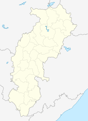 Bemetara  Bemetara Location in Chhattisgarh, India | |
| Coordinates: 21°42′N 81°32′E / 21.70°N 81.53°ECoordinates: 21°42′N 81°32′E / 21.70°N 81.53°E | |
| Country |
|
| State | Chhattisgarh |
| District | Bemetara |
| Government | |
| • President | Mr. Ashish Chhabra |
| Elevation | 278 m (912 ft) |
| Population (2011) | |
| • Total | 28,536 |
| Languages | |
| • Official | Hindi, Chhattisgarhi |
| Time zone | IST (UTC+5:30) |
| PIN | 491335 |
| Telephone code | 07824 |
| Vehicle registration | CG 25 |
| Website |
www |
Bemetara (Hindi: बेमेतरा) is a city of the state of Chhattisgarh, India.
Demographics
As of the 2011 census Bemetara is a city governed by the Bemetara Municipality, Bemetara district, in the state of Chhattisgarh. The total population in Bemetara city/town is 28,536 as per the survey of census during 2011 by Indian Government. Bemetara City Google Map and location
- There are 5,800 House Holds in Bemetara.
- There are 14,280 males (50%);
- There are 14,256 females (50%).
- Scheduled Cast are 2,398 (8%)
- Total Scheduled Tribe are 884 (3% ).
- Literates in the city/town are 20,012 (70%).
- There are 8,524 total Illiterates (30% ).
- Literates are 20,012 (70% ) and total Illiterates 8,524 (30%) in Bemetara.
- Bemetara Workers are 10,923 (38%). ** 9,718 are regular Workers and 1,205 are Irregular Workers.
- There are total of 17,613 Non Workers (62%) in Bemetara.
Being an important regional centre and a city with a history stretching back more than a hundreds years, as attracted people from different parts of Madhya Pradesh and neighbouring states. The population includes local ethnic Chhattisgarhis, North Indians, South Indians, and a few people from the North East. Local ethnic Chhattisgarhi comprises Kalar, Kurmi, Swarnkar, Teli, Bramhan, Koshta and Satnami communities. The city is also inhabited by the trading communities like Jayaswals, Baniyas, Agarwals, Jains, Gujaratis, and Marwaris. The city is also home to an immigrant population that includes Sindhis and the Sikhs. Majority of the population in Bemetara is Hindu. Muslims and sikhs . Muslims primarily reside in such areas as bajar para masjid gali...city is divided by castwise from local people like Bramhan para, Kurmi para, Panjabi para, Sindhi para etc...
Geography and climate
| Bemetara | ||||||||||||||||||||||||||||||||||||||||||||||||||||||||||||
|---|---|---|---|---|---|---|---|---|---|---|---|---|---|---|---|---|---|---|---|---|---|---|---|---|---|---|---|---|---|---|---|---|---|---|---|---|---|---|---|---|---|---|---|---|---|---|---|---|---|---|---|---|---|---|---|---|---|---|---|---|
| Climate chart (explanation) | ||||||||||||||||||||||||||||||||||||||||||||||||||||||||||||
| ||||||||||||||||||||||||||||||||||||||||||||||||||||||||||||
| ||||||||||||||||||||||||||||||||||||||||||||||||||||||||||||
Geography
BEMETARA is located near the centre of a large plain, sometimes referred as the "rice bowl of India", where hundreds of varieties of rice are grown.[1] The Shivnath River flows to the east of the city of bemetara, and the southern side has dense forests. The Maikal Hills rise on the north-west of Bemetara; on the north, the land rises and merges with the Chota Nagpur Plateau, which extends north-east across Jharkhand state. On the south of Bemetara lies the Deccan Plateau.
Climate
Bemetara has a tropical wet and dry climate, temperatures remain moderate throughout the year, except from March to June, which can be extremely hot. The temperature in April–May sometimes rises above 48 °C (118 °F).These summer months also have dry and hot winds. In summers, the temperature can also go up to 50 °C. The city receives about 1,300 millimetres (51 in) of rain, mostly in the monsoon season from late June to early October. Winters last from November to January and are mild, although lows can fall to 5 °C (41 °F).
| Climate data for Bemetara City | |||||||||||||
|---|---|---|---|---|---|---|---|---|---|---|---|---|---|
| Month | Jan | Feb | Mar | Apr | May | Jun | Jul | Aug | Sep | Oct | Nov | Dec | Year |
| Average high °C (°F) | 27 (81) |
30 (86) |
35 (95) |
39 (102) |
45 (113) |
36 (97) |
30 (86) |
30 (86) |
31 (88) |
31 (88) |
28 (82) |
26 (79) |
32 (90) |
| Average low °C (°F) | 13 (55) |
15 (59) |
20 (68) |
24 (75) |
27 (81) |
26 (79) |
23 (73) |
23 (73) |
22 (72) |
21 (70) |
16 (61) |
14 (57) |
20 (68) |
| Average precipitation mm (inches) | 10 (0.39) |
17 (0.67) |
14 (0.55) |
13 (0.51) |
18 (0.71) |
239 (9.41) |
383 (15.08) |
364 (14.33) |
197 (7.76) |
50 (1.97) |
11 (0.43) |
16 (0.63) |
1,330 (52.36) |
| Source: [2] | |||||||||||||
City structure
As it is largest town amongst other town in the scenario in the land & population, it is also surrounded by trees. The city has total 18 wards. Allons public school is first cbse school in Bemetara District and it is a largest school in Bemetara district.
List of Wards in Nagar Palika Parishad Bemetara
1* RAMDAS WARD रामदास वार्ड
2* SARDAR VALLABH BHAI PATEL WARD सरदार वल्लभ भाई पटेल वार्ड
3* SHAHID HEMOO KALANI WARD शहीद हेमू कलाणी वार्ड
4* PT. DINDYAL UPADHYAYA WARD पं. दीनदयाल उपाध्याय वार्ड
5* CHANDRASHEKHR AZAD WARD चन्द्रशेखर आजाद वार्ड
6* INDIRA GANDHI WARD इंदिरा गांधी वार्ड
7* GURU GOVIND SINGH WARD गुरू गोविन्द सिंह वार्ड
8* DR. BHIMRAV AMBEDKAR WARD डा.भीमराव अंबेडकर वार्ड
9* BABA RAMDEV WARD बाबा रामदेव वार्ड
10* SHAHID BHAGAT SINGH WARD शहीद भगत सिंह वार्ड
11* KARMA MATA WARD कर्मा माता वार्ड
12* PT. JAWAHAR LAL NEHRU WARD पं. जवाहर लाल नेहरू वार्ड
13* PARSHURAM WARD परशुराम वार्ड
14* RAJIV NAGAR WARD राजीव नगर वार्ड
15* MATA BHADRAKALI WARD माता भद्रकाली वार्ड
16* RAM MANDIR WARD राम मंदिर वार्ड
17* KABEER WARD कबीर वार्ड
18* MASJID WARD मस्जिद वार्ड
Education
- Serve Computers , Govt. Recognized Center New Bus Stand
- Allons Public School, Bijabhat
- Govt. H.S. Boys (Adarsh) Higher Secondary School
- Ambika H.S. school bemetara
- Saraswati Shishu Mandir
- Indian Public School
- Roselin Public School (Dir. - Miss Reshma John, Pre. - Mrs. Alice Dindore & Pri. - Miss Madhulika John)
- Govt. H.S. S Girls' School.
- Academic World School, lolesara, Bemetara
- Gyanodaya Public School, Near SDOP Office, Bemetara
- gurukul high school
- Shivlal Rathi Higher secondary school
- IMAGE IT INSTITUTE Behind civil court ward 3 bemetara (PGDCA, DCA) MUMT BILASPUR
- Bagga Computers, Bemetara 8109810950
- Genius Computer sales & Services, Bemetara 7879367891
And there are 12 govt primary and middle school in bemetara city....
Higher Education
- There is one of the oldest and famous college in Chhattisgarh named Govt. Pt. J.L.N. Arts & Science P.G. college in bemetara town
- Govt. Agriculture college
- Govt. Girls College
- Samadhan Mahavidyalaya
- Digitech Computer Centre Durg Road Bemetara (DCA, PGDCA, MBA, BBA, M.SC. IT) MO. 9425561440(M)
Administration
On 1 January 2012, Bemetara became a district Headquarters of Bemetara district. At present Dr. Basaw Raju is Collector of Bemetara and Ms Parul Mathur is the Superintendent of Police and Mr. Ashish Chhabra is currently municipality president.
Transportation
Roads
Bemetara city is well connected to Raipur, Jabalpur, Bilaspur, Durg and Kawardha by roadways.NH-12 A passes through the heart of city which is one of the buissiest road in the state.This highway connects state capital Raipur to one of the major city of Madhya Pradesh, Jabalpur.There are two state highway passing through Bemetara that are Durg to Bemetara and Kumhari - Bemetara - Mungeli.
Railway
There is not any railway line in bemetara district and the nearest Railway station is tilda(35 km) and major station is Raipur (66 km) and Durg is about 72 km .
A new railway line servay proposed in Bemetara is Durg-Bemetara-Mungeli-Bilaspur line.
Airport
Nearest airport to the town is Swami Vivekananda International Airport, Raipur(IATA: RPR, ICAO: VERP) which was formerly known as Mana Airport which is 66 km from the city.
Attractions in Bemetara
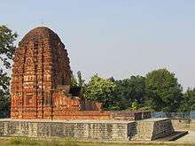
Mata Bhadrakali Temple
Bemetara city is called " Mata Bhadrakali ki Pavan Bhumi ".this temple is Siddh Shaktipith and is very famous and ancient.big fare is called here during Navaratra twice in every year..
Mata Shitla Temple
Shitla mata temple is another famous templtemple in city.the temple is three storied and very big...
Sita Devi Temple
In devarbija village 15 km from Bemetara Sita devi Temple is situated.temple is very ancient.it is called that during vanvasa Lord Shri Ram and Mata Sita stayed here for few times...
Somnath Temple
Somnath temple is situated at the bank of Shivnad and Kharun river 26 km from bemetara...this place is very panoramic...
Siddhi Mata Sandi
One of the largest and most famous temples in the district.
Attractions around Bemetara
- Kanha National Park
- Achanakmar Wildlife Sanctuary
- Amarkantak
- Bhoramdeo Temple
- Dongargarh
- Ratanpur Mahamaya Temple
- Sirpur
- Champaran
- Rajim
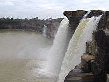
- Chitrakot Falls
- Indravati National Park
- Kanger Valley National Park
- Gangrel Dam
- Murrum Silli Dam
- Barnawapara Wildlife Sanctuary
- Jatmai-Ghatarani Waterfalls
- Kaivalya Dham Jain Temple
- Bhilai Steel Plant
- Purkhautin Muktangan Raipur
- Dudadhari math Raipur
- Shri Shami Ganesh Temple, NAvagarh
References
- ↑ "Chhattisgarh Details, Chhattisgarh Online, Chhattisgarh Information, Chhattisgarh State". Walkincg.com. Retrieved 2012-10-04.
- ↑ "Historical Weather for Bemetara, Assam, India". Whetherbase. Retrieved 18 July 2012.