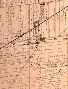
Bells Corners
| Bells Corners | |
|---|---|
| Community | |
 Bells Corners Location near Ottawa | |
| Coordinates: 45°19′20″N 75°50′00″W / 45.32222°N 75.83333°W | |
| Country |
|
| Province |
|
| Municipality | Ottawa |
| Bell's Corners | 6 August 1851 |
| Nepean Township | 1792 (Incorporated 1850) |
| Amalgamated | 2001 (City of Ottawa) |
| Named for | Hugh Bell |
| Government | |
| • Mayor | Jim Watson |
| • MP | Chandra Arya |
| • MPP | Lisa MacLeod |
| • City Councillor | Rick Chiarelli |
| Area | |
| • Total | 4.67 km2 (1.80 sq mi) |
| Elevation | 90 m (295 ft) |
| Population (2011) | |
| • Total | 9,468 |
| • Density | 2,047/km2 (5,300/sq mi) |
| Time zone | Eastern (EST) (UTC-5) |
| • Summer (DST) | EDT (UTC-4) |
| Postal code span | K2H |
| Area code(s) | 613, 343 |
Bells Corners is a suburban community in College Ward in the city of Ottawa, Ontario, Canada. It is located in the former city of Nepean within Ottawa's western Greenbelt. As of the Canada 2011 Census, the community had a population of 9,468.[1][2]
History
The community owes its existence to its location on the Richmond Road midway between Richmond Landing near Bytown (now Ottawa) and the military settlement at Richmond, at the junction with the concession road leading west to the Hazeldean neighbourhood in neighbouring Goulbourn Township. It was also the junction between Richmond Road and the "base line" which was the boundary road between concessions on the Ottawa front and those on the Rideau front. Hence, the plural "Corners". It was named after Hugh Bell, who owned a tavern on the site of the present day Bells Corners Public School from 1834 to 1863.[3]
Prior to that it was known locally as just "the Corners", but when the first post office opened on 6 August 1851[4] it had to adopt a formal name and became Bell's Corners.[5] Today it is most commonly spelled without the apostrophe.
In 1832, there were 9 taverns along this strip of road. Early stores catered to both local people and travelers.[6]
In 1841 the Carleton County Agricultural Society was formed and held its annual exhibition in Bells Corners until 1895, when it was moved to Goodwood Park in the Town of Richmond and later became the Richmond Fair.[7][8]
In 1850, Bells Corners became part of Nepean Township, Carleton County. The Town meeting to elect the first Council under the new system was held at Bells Corners on 7 January 1850. Frederick Bearman, J.P., Chester Chapman, James Spain, John Robertson, J.P., Michael Grady were elected as Councillors. The first Council meeting was also held in Bells Corners on 21 January 1850, when Colonel Frederick Bearman was chosen Reeve.[9] By 1852, there were 3 taverns, 3 shoe shops, 2 blacksmiths, 2 carpentry shops, a new store, and a tailor.
The Canada Directory for 1857-58 listed the population of Bells Corners at about 70. It listed the following people:[10]
- Arnold, George, postmaster, treasurer of township, and dealer in dry goods, groceries, hardware, produce, etc.
- Bell, George, farmer and reeve
- Bell, Hugh, hotel keeper, - a good house
- Burnside, Christopher, blacksmith
- Byers, William, lumber merchant and farmer
- Crow, Robert, shoemaker
- Davison, Samuel, deputy reeve
- Fannin, William H., teacher
- Gourlay, Rev. John, Free church
- Grahan, John, councillor
- Mahon, Edward, teacher
- Munroe, Donald, shoemaker
- Quinlan, Joseph, councillor
- Robertson, John, dealer in dry goods, hardware, groceries, produce, etc.
- Scales, Rev. W., Wesleyan
- Spittall, Alexander, blacksmith and carpenter,
- Stapleton, Thomas, clerk of township
- Taylor, Richmond, councillor
By 1866/7 Bells Corners was a post village with a population of 150 in the township of Nepean, county of Carleton, on the Ottawa and Nepean Macadamized road, 10 miles from Ottawa. The village had a daily mail, two stores, a school and a church which was used by the Church of England, Presbyterians, and Wesleyan Methodists. The early citizens included: Adam Abbott, a general merchant; Hugh I Bell, a farmer; George Arnold, a postmaster; E. Brown, a bailiff 7th Division Court; and William Brownlee, a general merchant boot & shoemaker.[11]
In 1866, the 43rd Battalion of Infantry (otherwise known as the Carleton Blazers) was formed in Bells Corners with companies in many of the surrounding communities and absorbed Ottawa's volunteer rifle company.[12]
By 1869, Bell's Corners was on the stage line from Town Ottawa to Perth. That directory listed the following individuals:[13]
- Arnold, George, Postmaster and general merchant
- Bearman, James, J. P.
- Bearman, John
- Brownlee, William, shoemaker
- Corbett, William, hotel keeper
- Crowe, Robert, shoemaker
- Dawson, John, J.P.
- Dowler, Rev, J. A. (Wesleyan)
- Draffin, Richard
- Gourlay, Rev. J. L, M.A., (Presbyterian)
- Graham, Thomas
- Graham, William
- Harmer, F. W., Municipal Clerk
- Keeman, D., teacher
- Lafleur, Andrew, wagon maker
- Moodie, Robert, hotel keeper
- Patton, Henry, cooper
- Pettit, Rev. C. B., M.A., (Church of England)
- Pratt, A. D., teacher
- Pratt, Isaiah, shoemaker
- Robertson, John, farmer
- Spittall, Alexander, wagon maker
- Spittall, R. P., carpenter
- Wright, Albert, tanner
Most of Bells Corners was destroyed by fire in August 1870.[14][15][16]
The oldest buildings in Bells Corners are the East India Company restaurant and conference centre, formerly Hartin's Hotel, built after the fire in 1870 on the site of Robert Malcomson's Tavern (David Hartin was married to Robert Malcomson's daughter Sarah); and, The Spa which occupies the old Drummond Methodist Church built in 1898. This church used stone from the old Union Church (now the site of the Bells Corners Union Cemetery on Old Richmond Road) built in 1853 and the only building in Bells Corners to survive the fire of 1870.[17]
Some notable residents of the time:
- George Arnold - postmaster and owner of Arnold's General Store
- Hugh Bell - tavern owner
- David Hartin[18] - hotel owner
- John Foster - farmer, councilman; settled 1832[19]
- Robert Malcomson[20] - tavern owner
- Robert Moodie Jr. - tavern owner, hotel keeper; settled 1850[19]
- John Robertson[21] - general store owner
- Richard Shore - carriage maker; settled 1877[19]
- A. Spittle - hotel keeper[19]
- Stephen H. Waggoner - toll gate keeper[19]
- C. J. Walker - farmer; settled 1878[19]
History of the Ottawa Valley, J. L. Gourlay, 1896: -
- John Dawson, nephew of the old bachelor pioneer, has taken a great interest in municipal affairs, and with his sons, has recently bought out the store of the late George Arnold, of pleasant memory, who had kept it for say fifty years. John Robertson began a store there, and one of his daughters kept it for some time. Kenneth McKaskill held it a time ...
Postmasters of Bell's Corners[22]
| Name of Postmaster | Military Status | Date of Birth | Date of Appointment | Date of Vacancy | Cause of Vacancy |
|---|---|---|---|---|---|
| George Arnold | 1851-08-06 | 1891-10-21 | Death | ||
| J.F. Arnold | 1892-01-22 | 1893-05-30 | Resignation | ||
| A.G. Dawson | 1893-07-06 | 1909-04-06 | Resignation | ||
| Mrs. M.A. Walters | 1909-05-18 | 1916-03-30 | Resignation | ||
| H.P. Leslie | 1916-04-27 | 1918-03-02 | Resignation | ||
| R.E. Williams | 1881-04 | 1918-05-30 | 1939-02-11 | Death | |
| Miss Jennie Pritchard Williams | * | 1939-02-11 | Acting | - | |
| Miss Jennie Pritchard Williams | * | 1939-03-10 | 1945-04-03 | Resignation | |
| Mrs. Dorothy Ermen Potter | * | 1945-05-09 | 1947-08-18 | * | |
| Donald Walter Plunkett | O.A.S. | 1947-10-22 | - |
The post office was closed on 1 February 1963 when it became the Bells Corners substation (now Postal Station H) of the Nepean Post Office.
Campbell's Quarry
On the north side of Robertson Road between Bells Corners and Hazeldean was the first of several Nepean sandstone quarries from which rock was taken for the exterior of the parliament buildings, Confederation Building, Connaught Building and what is now the Canadian Museum of Nature. It can be seen also in many smaller buildings throughout the city.[23] Dick Williams, a Welshman who came to Canada in 1902, opened a small quarry in the Nepean formation on the farm of his father-in-law on lot 3, concession II, Ottawa front.[24] The two began making paving stones in 1912 and in 1916 they were joined by a young Scot, Archie Campbell, a recently apprenticed quarryman. The quarry eventually became known as Campbell's Quarry.[25] Contracts were signed with seven different quarries, but the bulk of the stone for the Centre Block and the Peace Tower came from Campbell's Quarry.[26] According to Campbell "Our first order came from Peter Lyall Construction Company for 1,000 tons of sandstone all for the Parliament Buildings. When we got the parliament job there were several hundred men on the job and they just gobbled up the stone. We couldn't get the stone out fast enough ... Stone was hauled up to the building site by teams of horses, struggling along poor roads with six ton loads. Each team could make but one trip a day." The quarry continued operation under various owners until September 1962, when the National Capital Commission expropriated the land for part of Ottawa's Greenbelt. Natural Resources Canada offices, laboratories and experimental sites now occupy the quarry and surrounding property.[25] The workings of the quarry are reported to still be intact as they were when surveyed by Alice Wilson in the mid 1950s however the area is not open to the general public.[27]
Railways
The Central Canada Railway was chartered to run from the Brockville and Ottawa Railway at Carleton Place through Bells Corners to Bytown. This line opened on 15 September 1870. This was a broad gauge rail line and but was converted to standard gauge in 1880.[28] It was leased and then taken over by the Canadian Pacific Railway on 6 June 1881.[29] The Bells Corners Station was located to the northwest of the community approximately where Fitzgerald Road is now located. In 1915, Canadian Northern Railway (later Canadian National) built its mainline from Ottawa to Brent, Ontario just to the northeast of the community. A new Bells Corners Station was built on Northside Road just west of what was then known as Cedarview Road (now Cassidy Road) and an overpass was built east of Moodie Drive where the two competing rail lines crossed.[30]
On 28 February 1957 a Canadian National Continental train hit a tractor trailer at a Bells Corners crossing derailing two diesel units and ten passenger cars. There were only minor injuries to three persons on the train.[31]
The junction between the two rail lines, Bells Junction, was not installed until 29 July 1966. On 28 August 1967 at 12:00 noon, CP Rail abandoned what was then known as the Carleton Place Subdivision between McRae Avenue in Ottawa and Bells Junction. The remaining portion westward from the junction then became the Carleton Spur. The spur was also abandoned in 1982 and is now a part of the Trans Canada Trail from Fitzgerald Road to Carleton Place.[32]
The CN line continues to exist only as far as Pembroke and is known as the Beachburg Subdivision. However, this once continental line has been abandoned and CN has removed all of the track between Nepean Junction and Pembroke. This line also served a portion of the Pontiac region in west Quebec. Ottawa Central Railway operated a short line providing freight service on this track from 1998 to 2008 when it was bought out by CN. To this day, there still remains one freight movement per week through Bells Corners on the Renfrew Sub. This train provides Caprolactam to Nylene Canada Inc. in Arnprior.[33]
Transformation from a post village to a suburban neighbourhood of Ottawa
In 1950, Ottawa annexed the main urban areas of Nepean Township including Westboro, where the town offices were located. A new town hall was then built in Bells Corners at the intersection of Richmond (now Old Richmond Road) and Robertson Roads where Arnold's General Store had been, which was used from 1966 to the late 1980s, when a new Nepean city hall was built at Centrepointe. The City of Nepean was finally amalgamated with 10 other municipalities into the City of Ottawa in 2001.
Development
Once a rural community with many dairy farms, Bells Corners is now a residential, commercial and industrial island surrounded by greenbelt, woods and farmland. For a time Bells Corners was a hi-tech area and home to such Canadian technology icons as Computing Devices Canada, the Ottawa-based defence electronics company (bought by General Dynamics), which blazed the trail for later defence technology firms in what would become known as Silicon Valley North in neighbouring Kanata.
Many of the houses in Bells Corners are in a neighbourhood called Lynwood Village (Bells Corners East), built in the late fifties and early sixties. It is one of the first examples of tract housing in Ottawa. The first area to be developed was Stinson Avenue in 1950. This was followed by Arbeatha Park in 1955-58, and then Lynwood Village proper in 1958-66. In the fifties Nepean had acknowledged the rights of property owners to subdivide their land for housing but usually individual lots were sold to small builders. In Lynwood Village, land speculators Lloyd Francis and Donald Sim had assembled a vast tract of land. In 1958, they brought in Bill Teron to build the entire subdivision. By 1960, four hundred families lived in Teron's bungalows; another four hundred homes were built in 1961. Many more were built in 1962, 1963, 1964, and 1965. The last area of Lynwood to be developed was the area bounded by Richmond, Robertson, and Moodie Drive in 1966. Today there are over 1700 homes in the Lynwood area.[34]
The magnitude of the shift to tract housing is demonstrated by the fact that most of the subdivisions built in Ottawa during the rest of the sixties were the work of three large firms (Minto, Campeau and Assaly/Johannsen).
To the west of Lynwood Village is Westcliffe Estates (Bells Corners West), founded in 1969, it is a growing community of over 2000[35] homes. Assaly Construction and later the Thomas C. Assaly Corporation built most of the older (1969–76) homes in this area. The Westcliffe community is characterized by significantly higher residential densities than other parts of Bells Corners. There is a multi-storey housing complex operated by Nepean Housing as well as a multi-storey senior's residence and a co-operative housing project. The Terrace Drive/Mill Hill area of Westcliffe Estates was developed in 1986.
Bells Corners has a reputation as a retirement community, hosting three retirement homes in Lynwood Village and another in Westcliffe Estates.
Bells Corners is also the home of Bellwood Estates (formerly the Bellwood Mobile Home Park), consisting of 256 homes. The park was established in 1959 By Ken Hughes. It is now owned and operated by Parkbridge Lifestyle Communities.
Major roads which either serve or border Bells Corners include:
- 416 (Veterans Memorial Highway)
- 417 (Queensway)
- Baseline Road (Ottawa Road #16)
- Cedarview Road (Ottawa Road #23)
- Eagleson Road (Ottawa Road #49)
- Fallowfield Road (Ottawa Road #12)
- Hazeldean Road (Ottawa Road #36)
- Hunt Club Road (Ottawa Road #32)
- Moodie Drive (Ottawa Road #59 and Ottawa Road #11)
- Old Richmond Road (Ottawa Road #59)
- Robertson Road (Ottawa Road #36)
Recreation
Bells Corners has a tennis club, the Lynwood Park Tennis Club, which manages the courts for the City of Ottawa. The Valleystream Tennis Club is located nearby on Richmond Road. Bell Centennial Arena and two seasonal outdoor rinks provide facilities for skating and ice hockey. The arena is also used for lacrosse in the summer. There is an outdoor public swimming pool at Entrance Park in Lynwood and numerous soccer, football, baseball, softball and play areas in the nine public parks in the community.
- Arnold Park
- Entrance Park
- George Wilson Park
- Lynwood Park
- Priam Way Park
- Quinpool Park
- Trevor Park
- Westcliffe Park
- Williams Park
The City of Ottawa partners with not-for-profit community associations to provide a variety of programs and services in recreation, arts and culture, and sports.[36] Three such associations have been formed within Bells Corners - the Westcliffe Estates Community Association, the Lynwood Village Community Association, and the Arbeatha Park Community Association. In Bellwood Estates there is a homeowners association that represents the interests of tenants of the mobile home park.
Transit
Although many bicycle paths exist to the east, west, and north of the community, they do not connect to each other and cycling on the major thoroughfares (Robertson and Moodie) through the community can be particularly hazardous. Pedestrians do not fare much better, as most of the community has no sidewalks.
Effective 4 September 2011, public transit service to Bells Corners was modified[37] as OC Transpo re-organised many suburban routes. In these changes, Bells Corners made significant gains in accessibility to the centre of Ottawa, as the Transitway bus route 97 was extended from Bayshore to Bells Corners, providing half-hourly service directly from Bells Corners to downtown and South Keys Monday to Saturday, and hourly service Sunday. Route 118, the primary route in the community (every 15 minutes most of the day) which connects Bells Corners with Kanata, Algonquin College and Billings Bridge, also increases in frequency, particularly in rush hour. The rush hour express routes 66 and 69 that connect Bells Corners to downtown Ottawa saw slight reductions in service.
In the summer of 2011 an experimental bicycle taxi service was introduced within the community.[38]
Starting in 2013, modifications are being made to the Robertson Road and Moodie Drive intersection to increase capacity for through traffic.[39] A study is also being undertaken to consider widening West Hunt Club and Old Richmond Road immediately to the south of the community.[40]
| Preceding station | OC Transpo | Following station | ||
|---|---|---|---|---|
| Terminus | Route 97 | toward Airport |
Education
There are five schools in Bells Corners - a public and a Catholic elementary school, a public intermediate school, and a public and a French Catholic high school. Most students, unless they live quite close, take a bus to get to school.
Ottawa-Carleton District School Board
- Bells Corners Public School
- D. Aubrey Moodie Intermediate School
- Bell High School
- Our Lady of Peace Elementary School
Conseil des écoles catholiques du Centre-Est
Religion
There are seven churches and a mosque in Bells Corners.[41]
- Bell's Corners United Church
- Christ Church Anglican Bells Corners
- The Church of Jesus Christ of Latter-day Saints
- The Church of Pentecost Canada
- Emmanuel Alliance Church Of Ottawa
- Jamiatul Muslemeen (Jami Omar) Mosque
- St Martin de Porres Catholic Church
- The Church of Hope
Commercial
Bells Corners is probably best known for the commercial strip along Richmond and Robertson Roads, which is dominated by car-oriented retail uses, gas stations, restaurants, strip malls, shopping plazas, and automobile dealers. In 2009, the City of Ottawa designated the strip a Business Improvement Area under the Ontario Municipal Act.[42] Because of the residential development in neighbouring Kanata to the west, the strip is now a major thoroughfare for residents travelling to and from work within the city centre to the east. The amount of daily traffic, particularly during rush hour, can cause serious traffic congestion in Bells Corners. To the north of these roads lie the majority of commercial and industrial businesses, with most residential real estate located to the south. It is now proposed to build high-rise condominiums on this strip.[43] There was some considerable controversy over renaming Richmond and Robertson Roads. In the end it was decided to keep the Robertson name for both. The change took effect in 2012.
Wildlife
Bells Corners is an island, surrounded by Greenbelt and farmland. The area of the Greenbelt around Bells Corners is known as the Stony Swamp Conservation Area. It is the largest forested area of the Greenbelt and has a great diversity of trails with interpretive exhibits on the geology and natural history of the area.[44] Those, combined with the many trails that lead from Bells Corners through other natural areas, such as the Trans Canada Trail and the Rideau Trail, provide it with a wide diversity of urban wildlife. Squirrels, snowshoe hares, raccoons, skunks, chipmunks, groundhogs, beaver, and foxes are all native inhabitants. A large deer population makes the Greenbelt home but they can often be found roaming streets and yards at night. Black bears have been sighted,[45] as well as coyotes. There have been unconfirmed reports of a wolf in the area just to the west of Westcliffe Estates.
Other
In 2010, Bells Corners was the location for the feature-length film Going Thru a Thing produced and directed by former Bells Corners resident Jo Marr.[46] Bells Corners is the home of musician Tyler Kealey.[47] New York-based jazzman and saxophonist Michael Webster is also a former resident of Bells Corners.[48] Former NHL hockey star and general manager of the Tampa Bay Lightening Steve Yzerman is a former resident of Bells Corners where he attended Bell High School.
Author Marion Voytinsky (Face Your Fears, CreateSpace Independent Publishing Platform, 30 June 2013) is a resident of Bells Corners. The cover of her book features the Bel Air Motel.[49] Iain Reid's novel The Truth About Luck: What I Learned on My Road Trip with Grandma (House of Anansi, 20 February 2013) also references a Bells Corners motel.[50] In the fall of 1956, the first meeting of Radio Control Model Club, later to become the Ottawa Remote Control Club, was held at the Monarch Motel in Bells Corners.[51] Recently the remains of two other area motels were rediscovered in the Greenbelt just to the west of Bells Corners.[52]
See also
- Nepean Township
- Carleton County
- Nepean
- Ottawa
- College Ward (municipal)
- Nepean-Carleton (provincial)
- Nepean (federal)
References
- ↑ "Statistics Canada. 2012. 5050136.01, Ontario (Code 5050136.01) and Ottawa - Gatineau, Ontario (Code 505) (table). Census Profile. 2011 Census. Statistics Canada Catalogue no. 98-316-XWE. Ottawa. Released February 8, 2012.". Statistics Canada. Retrieved 15 March 2012.
- ↑ "Statistics Canada. 2012. 5050136.02, Ontario (Code 5050136.02) and Ottawa - Gatineau, Ontario (Code 505) (table). Census Profile. 2011 Census. Statistics Canada Catalogue no. 98-316-XWE. Ottawa. Released February 8, 2012.". Statistics Canada. Retrieved 15 March 2012.
- ↑ Bruce S. Elliott (1991). The city beyond: a history of Nepean, birthplace of Canada's capital, 1792-1990. Nepean, ON: City of Nepean. p. 461. ISBN 1-55036-258-5.
- ↑ "Post Offices and Postmasters". Philately and Postal History. Library and Archives Canada. Retrieved 26 August 2011.
- ↑ "Patchwork Communities of Historical Nepean". Rediscover Ottawa: Exploring the Capital's local history. Retrieved 23 August 2011.
- ↑ "Rural Nepean". Nepean Museum. Nepean Museum. Retrieved 24 February 2015.
- ↑ "Richmond Fair goes back to 1844". Ottawa Community News. Retrieved 2 October 2014.
- ↑ "History of the Richmond Fair". Richmond Agricultural Society. Retrieved 2 October 2014.
- ↑ "Excerpts from The Historical Atlas of Carleton County, Ont. H. Belden &Co. 1879". Bytown or Bust - History and Genealogy in the Ottawa, Canada area. Retrieved 26 February 2015.
- ↑ Lovell, John. "The Canada Directory for 1857-58". Google Books. John Lovell. Retrieved 24 February 2015.
- ↑ James Sutherland (1866). Ottawa City and Counties of Carleton and Russell Directory, 1866-7. Ottawa, ON: Hunter, Rose & Company.
- ↑ "The Carleton Blazers, 1866 to 1875". Regimental History. The Cameron Highlanders of Ottawa Foundation. Archived from the original on 1 July 2011. Retrieved 5 August 2011.
- ↑ The province of Ontario gazetteer and directory. H. McEvoy Editor and Compiler, Toronto : Robertson & Cook, Publishers, 1869
- ↑ "The Carleton County Fire" (PDF). Goulbourn Museum. Retrieved 27 July 2011.
- ↑ "Fires". Billings Estate Virtual Exhibit Web site. City of Ottawa. Retrieved 27 July 2011.
- ↑ Currie, Terence M. (2009). The Ottawa Valley's Great Fire of 1870 The Nineteenth Century Press and the Reality of a Great Disaster. Carp, ON: Creative Bound. ISBN 9781894439480.
- ↑ "Our History". Bells Corners United Church.
- ↑ "Bytown or Bust - History and Genealogy in the Ottawa, Canada are". Immigration and Settlement in Eastern Ontario and Western Quebec, Canada, in the 1800s Including the Cities of Ottawa and Hull / Gatineau. Bytown.net. Retrieved 23 August 2011.
- 1 2 3 4 5 6 "The Canadian County Atlas Digital Project". The Canadian County Atlas Digital Project. McGill University. Retrieved 22 January 2015.
- ↑ "Bytown or Bust - History and Genealogy in the Ottawa, Canada are". Immigration and Settlement in Eastern Ontario and Western Quebec, Canada, in the 1800s Including the Cities of Ottawa and Hull / Gatineau. Bytown.net. Retrieved 23 August 2011.
- ↑ Earl McRae (16 April 2011). "Who was John Robertson?". Ottawa Sun. Retrieved 17 April 2011.
- ↑ "Post Offices and Postmasters". Philately and Postal History. Library and Archives Canada. Retrieved 12 January 2015.
- ↑ Wilson, Dr. Alice E. (January–March 1956). "A Guide to the Geology of the Ottawa District". The Canadian Field-Naturalist. 70.
- ↑ Hewitt, D. F. (1964). "Building Stones of Ontario Part IV Sandstone" (PDF). Ontario Department of Mines. Retrieved 22 January 2015.
- 1 2 Lawrence, D. E. (March 2001). "Building Stones of Canada's Federal Parliament Buildings". Geoscience Canada. 28 (1).
- ↑ Nixon, Don (2012). The Other Side of the Hill : behind the scenes stories of Parliament Hill. Carleton Place, ON: Don Nixon Consulting Inc. ISBN 9781105408823.
- ↑ Sanford, Arnott, B.V., R.W.C. (2010). "Stratigraphic and structural framework of the Potsdam Group in eastern Ontario, western Quebec, and northern New York State" (PDF). Geologic Survey of Canada. Bulletin 597: 60. Retrieved 22 January 2015.
- ↑ "The Change of Gauge on the Canada Central Railway". Colin Churcher's Railway Pages. Retrieved 24 February 2015.
- ↑ "Brockville & Ottawa Railway". Index to Railways of Eastern Ontario. Retrieved 24 February 2015.
- ↑ "Canadian Rail" (PDF) (179). July–August 1966. Retrieved 22 February 2015.
- ↑ "Details of Railway Accidents in the Ottawa Area". Colin Churcher's Railway Pages. Retrieved 22 February 2015.
- ↑ "Significant Dates in Ottawa Railway History". Colin Churcher's Railway Pages. Archived from the original on 4 October 2005. Retrieved 22 February 2015.
- ↑ The Beachburg Sub http://beachburg.blogspot.ca/. Retrieved 22 February 2015. Missing or empty
|title=(help) - ↑ "Census tract profile for 0136.01 (CT), Ottawa - Gatineau (CMA) and Ontario". Statistics Canada. Retrieved 29 June 2011.
- ↑ "Census tract profile for 0136.02 (CT), Ottawa - Gatineau (CMA) and Ontario". Statistics Canada. Retrieved 25 June 2011.
- ↑ "Partners and Community Associations". Parks and Recreation. City of Ottawa. Retrieved 5 August 2011.
- ↑ "Check your route!". OC Transpo. Retrieved 8 August 2011.
- ↑ "New taxi service turning heads in Bells Corners". CBC. 4 August 2011. Retrieved 8 August 2011.
- ↑ "Implementation of Network Modifications to the intersection of Robertson Road and Moodie Drive". City of Ottawa. Retrieved 12 May 2013.
- ↑ Edwards, Blair (3 May 2013). "Ottawa considers building city's first ever reversible lane on Old Richmond Road". Your Ottawa Region. Retrieved 12 May 2013.
- ↑ "Churches and Mosques". Bells Corners Visitors' Guide. Retrieved 6 April 2016.
- ↑ "Intent to Designate Bells Corners BIA". City of Ottawa. Retrieved 24 June 2011.
- ↑ Laura Mueller (9 June 2011). "Condos coming to Bells Corners, says councillor". Your Ottawa Region. Retrieved 9 June 2011.
- ↑ "Stony Swamp". The National Capital Greenbelt. National Capital Commission. Retrieved 7 March 2013.
- ↑ Lauren Davis; Brock Smith (27 May 2011). "Bear Spotted in Bells Corners". 580 CFRA News Talk Radio. Retrieved 28 May 2011.
- ↑ Steph Willems (9 June 2011). "Centrepointe screens feature-length film shot in Ottawa". Nepean/Barrhaven EMC. Retrieved 11 June 2011.
- ↑ Blair Edwards (20 June 2012). "From the darkness to the light: Tyler Kealey to perform songs from his new album at Bluesfest". YourOttawaRegion.com. Metroland. Retrieved 7 July 2012.
- ↑ Hum, Peter (24 March 2013). "Jazz saxophonist Michael Webster to play NAC Fourth Stage". Ottawa Citizen. Retrieved 24 March 2013.
- ↑ Voytinsky, Marion. "Face Your Fears". Amazon.co.uk. CreateSpace Independent Publishing Platform. Retrieved 21 January 2015.
- ↑ Reid, Iain. "The Truth About Luck: What I Learned on My Road Trip with Grandma". Google Books. House of Anansi. Retrieved 21 January 2015.
- ↑ Chippendale, Nigel. "Nomination for lifetime achievement award: Lou MacDonald" (PDF). Model Aeronautics Association of Canada. Model Aeronautics Association of Canada. Retrieved 21 January 2015.
- ↑ King, Andrew. "NO VACANCY: How we found the remains of an old motel in the Greenbelt". OttawaStart Internet Services. OttawaStart Internet Services. Retrieved 21 January 2015.
- ↑ Larry D. Cotton (2007). Whiskey and Wickedness. Lanark, ON: Larry D. Cotton Associates. p. 124. ISBN 978-0-9784875-0-8.
- ↑ J. L. Gourlay (1896). History of the Ottawa Valley. Ottawa, ON. p. 288.
- ↑ Bruce S. Elliott (1991). The City Beyond: A History of Nepean, Birthplace of Canada’s Capital 1792-1990. Nepean, ON: City of Nepean. p. 461.
External links
- Westcliffe Estates Community Association (WECA)
- Lynwood Village Community Association (LVCA)
- Bellwood Community Homeowners Association
- Bells Corners Business Improvement Area
- Ottawa Neighbourhood Study - Bells Corners East
- Ottawa Neighbourhood Study - Bells Corners West
- Bells Corners Visitors' Guide
 |
Beaverbrook | Crystal Beach | Qualicum Park | |
| Katimavik-Hazeldean, Glen Cairn | |
Leslie Park | ||
| ||||
| | ||||
| Bridlewood | Fallowfield | Trend-Arlington |
Coordinates: 45°19′20″N 75°50′00″W / 45.32222°N 75.83333°W