Bellingham, Tasmania
| Bellingham Tasmania | |
|---|---|
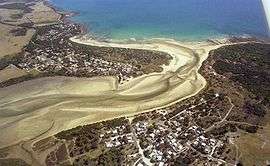 Aerial photo of Bellingham (right) and Weymouth (left) | |
 Bellingham | |
| Coordinates | 41°01′S 147°10′E / 41.017°S 147.167°ECoordinates: 41°01′S 147°10′E / 41.017°S 147.167°E |
| Population | 264 (2006 census)[1] |
| Postcode(s) | 7254 |
| Location |
|
| LGA(s) | George Town Council |
| State electorate(s) | Bass |
| Federal Division(s) | Bass |
Bellingham is a tiny coastal hamlet in Northern Tasmania, situated on the mouth of the Pipers River directly opposite the town of Weymouth. The town is located 62 kilometres (39 mi) from Launceston, 20 kilometres (12 mi) from Bridport and 40 kilometres (25 mi) from George Town. At the 2006 census, Bellingham and the surrounding area had a population of 264.[1]
Description & History
The township is largely made up of shacks used during the summer time. The permanent residence is about 25 people. In recent years the George Town Council has completed upgrade projects on many of the township's roads, including sealing works on the main Bellingham Road as well as base graveling on Gees Marsh Road, allowing better access to the central township and surrounding areas.

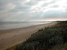
There is a camping ground, tennis court and small boat ramp within the central township, The Marine and Safety Board of Tasmania (MAST) recently announcing funding for a much-needed upgrade for the ramp. the nearby shoreline of the Pipers River can easily be accessed from the town, as well as large coastal beaches adjacent to Bass Strait.
Miller's Beach can be accessed by Four-wheel drive from Gees Marsh Road and marks the beginning of a designated 4wd route that traverses the beaches and sand dunes of Noland Bay and St. Albans Bay, before arriving at Briport.
Originally called Pipers Heads, Bellingham was first used as a watch for sailing vessels that went up the Pipers River to Weymouth. The wharf at Weymouth was burnt down at the turn of the century, leaving a number burnt pilons in the river sand that remain to this day.
Controversies
Recently, the Tasmanian Government altered Crown Land arrangements in the nearby Gees Marsh hamlet, just east of the main township, so that certain shack owners were allowed to buy the previously public-hold land on which their shacks were located. Unfortunately, some shacks were declared unsafe and were forcibly demolished, creating anger amongst local shack owners, many of whom had used these shacks for generations. Shacks such as "Ghost Shack", a landmark that was brought to her present location in 1939 on a sledge at lower Gees Marsh road, as well as "Butterworths Shack", which was originally built in the 1920s before being extended and later abandoned, falling to vandalism and disrepair in recent years, were amongst those that were removed.
Decisions made by the George Town Council to demolish local community halls and other public facilities in the township, due to disrepair and unsustainable insurance costs, have also created controversy. Local and transient-summer residents have actively campaigned against the decisions and have requested that the Council maintain funding and upgrade the facilities to an acceptable level. Suggestions include the construction of new toilet facilities and disabled access ramps.
Fordington
Further East from the main township, alongside the Little Pipers River, there was a town surveyed as Fordington that was, up until 20 years ago, a boom area. As the town's population decreased, the State Lands Department created controversy in ordering many off their land in the area, designating most of it either as uninhabitable crown land or privately owned property. On Christmas Day in 2001, a large tidal surge swept up the Little Pipers, the evidence of which can still be observed in large-scale vegetation and riverbank damage in the low-lying areas adjacent to the coast. Although no warning to the deserted river area now, there were at least two witnesses to the surge who were either present at the time of the surge or passed by the area on that day whilst headed along the beach.
References
- 1 2 Australian Bureau of Statistics (25 October 2007). "Bellingham (State Suburb)". 2006 Census QuickStats. Retrieved 2007-08-18.