Belezma Range
| Belezma Range بلزمة | |
|---|---|
|
Landscape of the Belezma Range | |
| Highest point | |
| Peak | Djebel Refâa |
| Elevation | 2178 |
| Coordinates | 35°40′0″N 5°54′0″E / 35.66667°N 5.90000°ECoordinates: 35°40′0″N 5°54′0″E / 35.66667°N 5.90000°E |
| Dimensions | |
| Length | 80 km (50 mi) ENE/WSW |
| Width | 30 km (19 mi) NNW/SSE |
| Geography | |
 Belezma Range بلزمة | |
| Country | Algeria |
| State/Province | Batna |
| Parent range | Aurès Mountains |
| Geology | |
| Orogeny | Alpine orogeny |

The Belezma Range, also transliterated as Belzma (Arabic: بلزمة), is a prolongation of the Aurès Mountains, at the confluence of the Tell Atlas and the Saharan Atlas in northeastern Algeria. It is separated from the main Aurès Range by the Batna-El Kantara basin.
Geography and vegetation
The ridge is roughly aligned in an E-W direction. It is located at the western end of the Aurès Range, with the Hodna Mountains to the west. The highest peak, at 2,178 meters, is the Djebel Refâa. Other important peaks are 2,136 m high Djebel Tichaou and 2,090 m Djebel Touggourt (meaning 'Cedar Peak').
The Belezma Range has one of the most important natural Atlas Cedar forests of Algeria. It is qualified as a 'dry facies' pure forest owing to its location and the influence of the large deserts nearby, being located only 40 km north of the El Kantara gorges, and there has been a high mortality of the trees in recent times.[1]
The Belezma mountains have been traditionally inhabited by the Houaras Chaoui people. There is very low population density in the area and villages are few.
Belezma Plain
The Belezma Plain (French: Plaine de Belezma) is an elevated intermontane basin located to the Northwest between the area of the National Park and Mount Mestaoua. Its main town is Merouana at 1012 m over sea level. The plain is one of the most fertile areas in the region and has traditionally been a granary for the local population. Mount Mestaoua, a veritable natural fortress, is a historical oppidum.
History
The Ksar of Belezma (35°40′35″N 5°54′09″E / 35.676402°N 5.902405°E) to the north of the range is the site of an ancient Byzantine fortress. The now ruined structure was once used as an observation outpost by the Muslim and Arab dynasties that followed the Byzantine domination.
This massif was the last refuge of Abu Yazid before his death.[2]
Protected areas
The Belezma National Park is a protected area on the slopes of the range. It is one of the most important national parks of Algeria.[3]
Features
 View of the range with snow and the ruins of the Belezma ksar in the forefront. |
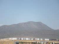 View of one of the mountains of the range. |
 Hills of the Belezma range near Merouana and a view of the fertile plain in the distance. |
See also
References
- ↑ Briki Athmane, Mortalité du cèdre de l'Atlas dans la région des Aurès
- ↑ Conant, Jonathan (2012). Staying Roman : conquest and identity in Africa and the Mediterranean, 439-700. Cambridge New York: Cambridge University Press. p. 280 -281. ISBN 0521196973.
- ↑ Belezma National Park - Travel to Algeria
External links
 Media related to Aurès Mountains at Wikimedia Commons
| Tell Atlas |
|
|---|---|
| Saharan Atlas |
|
| Saharan massifs | |
| Peaks |
|