Beersel
| Beersel | |||
|---|---|---|---|
| Municipality | |||
|
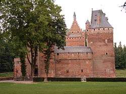
Beersel Castle | |||
| |||
 Beersel Location in Belgium | |||
|
Beersel in the Province of Flemish Brabant  | |||
| Coordinates: 50°46′N 04°18′E / 50.767°N 4.300°ECoordinates: 50°46′N 04°18′E / 50.767°N 4.300°E | |||
| Country | Belgium | ||
| Community | Flemish Community | ||
| Region | Flemish Region | ||
| Province | Flemish Brabant | ||
| Arrondissement | Halle-Vilvoorde | ||
| Government | |||
| • Mayor | Hugo Vandaele (CD&V) | ||
| • Governing party/ies | CD&V/N-VA, SP.A/Groen! | ||
| Area | |||
| • Total | 30.01 km2 (11.59 sq mi) | ||
| Population (1 January 2016)[1] | |||
| • Total | 24,745 | ||
| • Density | 820/km2 (2,100/sq mi) | ||
| Postal codes | 1650, 1651, 1652, 1653, 1654 | ||
| Area codes | 02 | ||
| Website | www.beersel.be | ||


Beersel (Dutch pronunciation: [ˈbeːrsəl]) is a municipality located in the Belgian province of Flemish Brabant. The municipality comprises the towns of Alsemberg, Beersel proper, Dworp, Huizingen and Lot. On 1 January 2006 Beersel had a total population of 23,433. The total area is 30.01 km² which gives a population density of 781 inhabitants per km². It is close to Brussels; Beersel is approximately 12 km southwest of the center of the city.
Beersel is perhaps best known for the "Kasteel van Beersel" (Beersel Castle), built between 1300 and 1310 by Jan II, the Duke of Brabant, as a defense for Brussels. Guillaume Dufay (1397–1474), the most famous European composer of the 15th century, was most likely born in Beersel.
Beersel is known for its boterham met plattekaas en radijzen (sandwich with white cheese and radishes), usually served with a geuze beer, and for its mandjeskaas (literally 'basket cheese'), which is a white cheese stored in little baskets. Beersel also has two traditional, authentic geuze breweries, Oud Beersel and 3 Fonteinen.
Famous people
- Eugène Prévinaire (1805-1877, Huizingen), second governor of the National Bank of Belgium (NBB) from 1870 until 1877
- Herman Teirlinck (1879-1967), writer
- Stéphane Demol (1966), current assistant manager of the Belgian national football squad
- Morten Olsen (1949), current manager of the Danish national football squad
- Karel Van Miert (1942-2009), former European Commissioner
- Guillaume Dufay (1397? – 1474), Burgundian composer
- Maarten Devillé (1986 - ), famous bass player
References
- ↑ Population per municipality as of 1 January 2016 (XLS; 397 KB)
External links
 Media related to Beersel at Wikimedia Commons
- Official website - Only available in Dutch
- Gazetteer Entry
 |
Sint-Pieters-Leeuw | Drogenbos | Linkebeek | |
| |
Sint-Genesius-Rode | |||
| ||||
| | ||||
| Halle | |
Braine-l'Alleud (WBR) |