Beacon Hill, Seattle
Beacon Hill is a hill and neighborhood in southeast Seattle, Washington. The municipal government subdivides it into North Beacon Hill, Mid-Beacon Hill, Holly Park, and South Beacon Hill,[1] though most people who live there simply call it "Beacon Hill." Former home to the world headquarters of Amazon.com and present home to the Seattle Division of the Department of Veterans Affairs' Puget Sound Health Care System, the hill offers views of downtown, the Industrial District, Elliott Bay, First Hill, Rainier Valley, and, when the weather is good, Mount Rainier and the Olympic Mountains. It is roughly bounded on the west by Interstate 5, on the north by Interstate 90, on the east by Rainier Avenue South, Cheasty Boulevard South, and Martin Luther King Junior Way South, and on the south by the Seattle city boundary. Homes on the northern part of the hill were mostly built in the early 1900s; thus, North Beacon Hill contains many excellent examples of Craftsman bungalows and Seattle box houses, a local variant of the Foursquare style.
The American Planning Association (APA), an organization of "planners, citizens and elected officials - committed to making great communities happen", named Beacon Hill as one of the 30 Great Places in America. The features of Beacon Hill that constitute an APA Great Place include urban design and aesthetics, multi-modal transportation, a variety of uses within the neighborhood, sustainability, community participation and involvement, and memorable character. Beacon Hill was also recognized for having the largest Olmsted-planned green space in Seattle, known as Jefferson Park. The neighborhood is highly treasured by its businesses and residents, and the neighborhood is highly involved in local planning affairs such as open space, public safety, and transportation.
The Beacon Hill neighborhood prides itself on many fine foods and restaurants, a highly rated hair salon, the best live music venue, and a place for kids activities, all voted for as some of the "Best of 2012" by Seattle Magazine (online version not currently available). The City of Seattle, in partnership with Beacon BIKES, created the Beacon Hill Family Bicycle and Pedestrian Circulation Plan, a ten-year plan to increase pedestrian bicycle networks serving highly used greenways, intersections, and cycle tracts within the neighborhood as a measure to increase safety for all users. The plan was awarded the 2012 VISION 2040 Award from the Puget Sound Regional Council.
Beacon Hill is home to the "Beacon Rocks!" performance series, beginning its 5th season in 2014 on the last Sunday of June, July and August. This event featuring a variety of types of performances is held on the Roberto Maestas Festival Street[2] and produced by Beacon Hill's neighborhood community arts group "ROCKiT Community Arts".[3]
Beacon Hill has recently become known for their Food Forest, a new project that has created neighborhood urban farming west of Jefferson Park. The Beacon Food Forest has gained national attention in the news, receiving recognition from the Associated Press, CBS, Gawker, and HLN, to name a few. A 2012 article in Seattle Weekly stated that Beacon Hill was soon to "boast the biggest public food forest in the country" with seven lush acres containing a community park and an edible landscape, including such plantings as walnuts, chestnuts, berry shrubs and vegetables. The idea started with a community-led group that secured $22,000 in Neighborhood Matching Funds from the Department of Neighborhoods.
History and demographics
The Duwamish called the hill "Greenish-Yellow Spine" (Lushootseed: qWátSéécH), probably referring to the color of the deciduous trees that once grew thickly on the hill.[4] Early settlers named it Holgate and Hanford Hill after two early settlers, John Holgate and Edward Hanford, who settled in the area in the 1850s[5] and are commemorated to this day by South Holgate and Hanford Streets on North Beacon Hill. A later arrival, M. Harwood Young, named the hill after the Beacon Hill in his hometown, Boston, Massachusetts.
Beacon Hill was nicknamed "Boeing Hill" in the 1950s and 60s due to the number of residents who worked in the nearby [Boeing] airplane factory. The term fell out of use when many Boeing employees joined the general exodus to the suburbs, and Asian immigrants took their place. Today the neighborhood is majority Asian, as can be seen by the many Chinese, Vietnamese, and Filipino businesses along Beacon Avenue South. However, the area remains racially diverse, as shown by the United States 2000 Census: 51% Asian, 20% white, 13% black, 9% Hispanic/Latino and 7% other.[6] The census also showed the total Beacon Hill population to be 22,300. Neighboring Rainier Valley also shows a similar diversity.
Landmarks and institutions
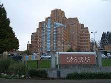
- Pacific Medical Center (PacMed) located at the northern tip of Beacon Hill. Formerly a marine hospital, the building served as headquarters to Amazon.com for ten years.
- Jefferson Park: Golf, lawn bowling, skate park, Beacon Mountain Playground, tennis courts, open space and more. Golf professional Fred Couples was raised in the neighborhood and Jefferson Park was his home course as a teen.
- Beacon Food Forest is one of the nation's largest food forest projects in the United States and will be breaking ground in 2012, adjacent to the west side of Jefferson Park.
- Comet Lodge Cemetery (1895)
- Dr. Jose Rizal Park: views to the west overlooking downtown, Elliott Bay and Olympic Mountains; start of bike path to I-90 bridge, Lake Washington, Mercer Island, Eastgate[7]
- El Centro de la Raza, a civil rights and community service organization, in the former Beacon Hill School built in 1904[8]
- Beacon Hill First Baptist Church:[9] a designated historic landmark Tudor Revival building built in 1910, designed by notable architect Ellsworth Storey
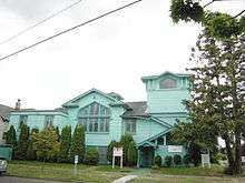 Beacon Hill First Baptist Church
 - The Frank D. Black property:[10] designated landmark river rock structures built in 1914
- Cheasty Greenbelt/Cheasty Boulevard Trail
- Beacon Hill Station of Sound Transit Light Rail, located at Beacon Avenue South and South Lander Street
- Beacon Hill branch of the Seattle Public Library, reopened in a new building and location in 2005
- Beacon Hill International Elementary School, a K-5 school that offers bilingual and diverse programs
Nearby neighborhoods
- Columbia City
- Downtown Seattle
- First Hill
- Georgetown
- Industrial District (see also SoDo)
- International District/Chinatown
- Judkins Park
- Mount Baker
- Rainier Valley
- Rainier Beach
- SoDo
Notes
- ↑ "Beacon Hill". Seattle City Clerk's Neighborhood Map Atlas. City Clerk's Office, City of Seattle. Retrieved 2005-09-03.
- ↑ "Roberto Maestas to be honored during Beacon Rocks!".
- ↑ "ROCKiT Community Arts". Archived from the original on 2013-09-05.
- ↑ Thrush, Coll (2007). Native Seattle: Histories from the Crossing-Over Place. University of Washington Press. p. 230. ISBN 0-295-98700-6.
- ↑ George Lange (November 10, 2000). "John Holgate explores the Duwamish River by canoe but does not stake King County land claim during the summer of 1850". Essay 1749. HistoryLink.org. Retrieved 2005-09-03.
- ↑ "2000 Census Data: Beacon Hill". Retrieved 2005-09-03.
- ↑ David Wilma (April 5, 2001). "Rizal Park". Essay 3168, Online Encyclopedia of Washington State History. HistoryLink.org. Retrieved 2005-09-03.
- ↑ David Wilma (August 2, 2000). "Chicano activists occupy abandoned school that becomes El Centro on October 11, 1972". Essay 2588, Online Encyclopedia of Washington State History. HistoryLink.org. Archived from the original on 19 August 2005. Retrieved 2005-09-03.
- ↑ David Wilma (April 17, 2002). "Seattle Landmarks: Beacon Hill First Baptist Church (1910)". Essay 3216, Online Encyclopedia of Washington State History. HistoryLink.org. Archived from the original on 4 September 2005. Retrieved 2005-09-03.
- ↑ David Wilma (April 23, 2001). "Seattle Landmarks: Frank D. Black Property (1914)". Essay 3226, Online Encyclopedia of Washington State History. HistoryLink.org. Archived from the original on 16 August 2005. Retrieved 2005-09-03.
References
- Merrell, Frederica and Mira Latoszek (2004). Seattle's Beacon Hill (Images of America). Charleston: Arcadia Publishing. ISBN 0-7385-2861-7.
External links
| Wikimedia Commons has media related to Beacon Hill, Seattle, Washington. |
- North Beacon Hill Neighborhood Council
- Beacon Hill Merchants Association
- Northwest Beacon Hill / Beacon Alliance of Neighbors website
- Seattle City Neighborhood Map of Beacon Hill
- Seattle Post-Intelligencer Beacon Hill Webtown
- South Beacon Hill Neighborhood Council
- * [http://beaconhill.seattle.wa.us/]
Coordinates: 47°34′48″N 122°18′54″W / 47.580°N 122.315°W