Bayn al-Qasrayn
Bayn al-Qasrayn is the district and plaza between two palaces constructed by the Fatimid dynasty in mediaeval Islamic Cairo, within present day Cairo, Egypt. It is an element in the Fatimid Caliphate founding of the new city of Cairo.
Fatimid founding
The Fatimid dynasty established itself in Egypt in 969 C.E. Upon their arrival the Fatimid caliphs began to build a new state north of the old capital city of Fustat. Gawhar al-Siqilli, a Fatimid general, founded the new city Cairo. He was in charge of planning, building and constructing the new city of Cairo. He organized the town in such a way that the caliphal palace was at the center.
Fifty years after the construction of the first palace, another smaller palace was erected to the west of the first. The area and plaza between these two palaces received the name of “Bayn al-Qasrayn”.[1]
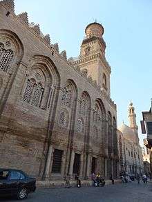
Ayyubid development
As the centuries progressed, Cairo developed into a full-scale urban center. Beginning with the Ayyubids and continuing thought the Bahri Mamluk rule, the higher powers of the city wanted to rid the area of its past Fatimid history, starting with the center palace structures. The palaces and the area surrounding them were reconstructed. Thus, the area became the central location in the immense city.
Ibn Batutah, who visited in 1326, reinforced this concept and commented that the space of Bayn al-Qasrayn was, “beyond one’s ability to describe.” [2] The additional buildings include hospitals, tombs, educational centers and commercial shops, making the area of Bayn al-Qasrayn a busy street. The Egyptian historian Al-Maqrizi counted 12,000 shops on Qasabah Street alone.[3]
Qasabah Street
Qasabah Street became the main commercial street stemming from the Bayn al-Qasrayn in Fatimid Cairo, where book dealers, spice and nut suppliers, saddle makers, and cloth merchants sold their goods to the people of Cairo.[4] The Bayn al-Qasrayn became totally integrated as Qasabah Street during the Bahri Mamluk era.
From the original Bayn al-Qasrayn layout the Qasabah expanded into a mile-long street which extended from the northern to the southern gates of the city.[5]
Notes
- ↑ Çelik, Zeynep, Diane G. Favro, and Richard Ingersoll, eds. Streets: Critical Perspectives on Public Space. Berkeley: University of California Press, 1994, p. 72
- ↑ M. ibn Batutah, The Travels of Ibn Batutah (1326), H.A.R Gibb, trans., volI (Cambridge, 1958), 4.
- ↑ Max Rodenbeck, Cairo: The City Victorious. Alfred Knopf; New York, 1999. p82
- ↑ G. Wiett, Cairo: City of Art and Commerce (Norman, 1964), 99
- ↑ Çelik, Zeynep, Diane G. Favro, and Richard Ingersoll, eds. Streets: Critical Perspectives on Public Space. Berkeley: University of California Press, 1994, p. 77