Sevastopol Bay
| Sevastopol Bay | |
|---|---|
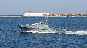 Ukrainian Navy artillery boat U170 in the Bay of Sevastopol | |
| Coordinates | 44°37′10″N 33°32′24″E / 44.61931°N 33.53988°ECoordinates: 44°37′10″N 33°32′24″E / 44.61931°N 33.53988°E |
| Type | bay |
| Primary inflows | Chorna River |
| Primary outflows | Black Sea |
| Basin countries |
|
Sevastopol Bay (Ukrainian: Севастопольська бухта; Russian: Севастопольская бухта) is a city harbor that includes a series of smaller bays carved out its shores. The bay of Sevastopol splits the city of Sevastopol into the Southern side and the Northern side. It serves as an extension of the Chorna River and stretches for 7.5 km (4.7 mi) which is the longest of them all.
The bays form a unique attraction of Sevastopol. The city stands like an elevated amphitheater on their shores, and the bays give it an extraordinary charm. The bay of Sevastopol stretches from the open sea eastward to the Inkerman Monastery at the end, narrowing down and finishing at the mouth of the Chorna river. The bay forms the seaward approach to the city. Covering a large expanse of water, the harbor serves as a comfortable anchorage for a fleet. From the beginning of the 20th century it housed cruisers and ironclads. The number of piers along the shores of the harbor far exceeds the number of bays.
See also
References
External links
- Description of Sevastopol Harbor
- Description of all bays around Sevastopol
- More information (aerial photo)