Batura Muztagh
"Batura" redirects here. For the Indian bread, see Bhatoora.
| Batura Muztagh | |
|---|---|
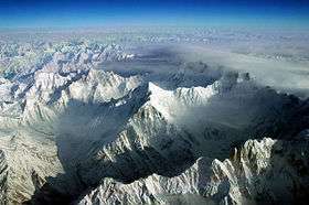 Aerial view of part of the Batura Muztagh from the southeast | |
| Highest point | |
| Peak | Batura Sar |
| Elevation | 7,795 m (25,574 ft) |
| Coordinates | 36°30′36″N 74°31′37″E / 36.51000°N 74.52694°ECoordinates: 36°30′36″N 74°31′37″E / 36.51000°N 74.52694°E |
| Geography | |
| Country | Pakistan |
| State/Province | Gilgit District |
| Parent range | Karakoram |
The Batura Muztagh mountains are a sub-range of the Karakoram mountain range. They are located west of the Hunza Valley in the Gilgit District of the Gilgit-Baltistan province in northern Pakistan.
They are the westernmost sub-range of the Karakoram, running from Chalt village in Bar Valley in the east to Kampir Dior in the Kurumbar Valley in the west, and they separate the Pamir and Hindu Kush ranges from the Karakoram range.
Selected peaks in the Batura Muztagh
| Mountain | Height (m) | Height (ft) | Coordinates | Prominence (m) | Parent mountain | First ascent | Ascents (attempts) |
|---|---|---|---|---|---|---|---|
| Batura Sar | 7,795 | 25,574 | 36°30′36″N 74°31′27″E / 36.51000°N 74.52417°E | 3,118 | Distaghil Sar | 1976 | 4 (6) |
| Shispare | 7,611 | 24,970 | 36°26′26″N 74°40′51″E / 36.44056°N 74.68083°E | 1,240 | Batura Sar | 1974 | 3 (1) |
| Pasu Sar | 7,476 | 24,528 | 36°29′16″N 74°35′16″E / 36.48778°N 74.58778°E | 645 | Batura Sar | 1994 | 1(0) |
| Ultar Sar | 7,388 | 24,239 | 36°23′54″N 74°42′32″E / 36.39833°N 74.70889°E | 700 | Shispare | 1996 | 2 (5) |
| Sangemarmar Sar | 7,000 | 22,966 | 36°25′31″N 74°33′38″E / 36.42528°N 74.56056°E | 1,100 | Pasu Sar | 1984 | 1 (3) |
| Bublimotin (Ladyfinger Peak) | 6,000 | 19,685 | 36°22′12″N 74°39′00″E / 36.37000°N 74.65000°E | <200 | Hunza Peak | 1982 | 2 (5) |
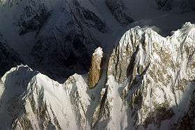
Bublimotin and Hunza Peak, southeastern Batura Muztagh
Books, pamphlets, and maps about Batura Muztagh
- High Asia: An Illustrated History of the 7000 Metre Peaks by Jill Neate, ISBN 0-89886-238-8
- Batura Mustagh (sketch map and pamphlet) by Jerzy Wala, 1988.
- Orographical Sketch Map of the Karakoram by Jerzy Wala, 1990. Published by the Swiss Foundation for Alpine Research.
See also
Notes
- ^ This data is from the Himalayan Index and is not always correct. In particular it is not clear if Batura Sar has really had four ascents or only three.
- ^ Sometimes called Batura I.
- ^ Sometimes called Ultar II or Bojohagur Duanasir II.
- ^ Also known as Sang-e-Marmar (or Sangemarmar), and sometimes referred to by locals as Marble Peak.
- ^ The heights given for this peak vary between 6949m and 7050m.
- ^ This elevation is approximate.
External links
| Wikimedia Commons has media related to Batura Muztagh. |
- Himalayan Index
- A clickable map of the Batura Muztagh
- DEM files for the Himalaya (Corrected versions of SRTM data; look for the "Batura Sar" tile)
This article is issued from Wikipedia - version of the 2/4/2016. The text is available under the Creative Commons Attribution/Share Alike but additional terms may apply for the media files.