Battle of Simancas
| Battle of Simancas | |||||||
|---|---|---|---|---|---|---|---|
| Part of the Reconquista | |||||||
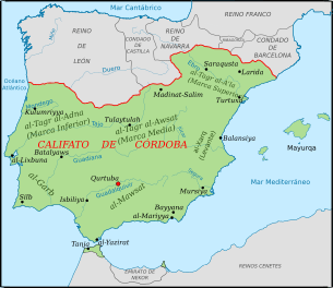 Map of the Caliphate of Cordoba circa 1000. | |||||||
| |||||||
| Belligerents | |||||||
|
|
| ||||||
| Commanders and leaders | |||||||
|
Fernán González of Castile García Sánchez I of Pamplona | Abd-ar-Rahman III | ||||||
Part of a series on the |
|---|
| History of Spain |
.svg.png) |
| Timeline |
|
|
The Battle of Simancas (also called Alhandega or al-Khandaq) was a military battle that started on July 19, 939, in the Iberian Peninsula between the troops of the king of León Ramiro II and Cordovan caliph Abd al-Rahman III near the walls of the city of Simancas. The battle decided the control of the lands of the Duero.
The battle unfolded after the army of Abd al-Rahman III launched toward the northern Christian territories in 934. Abd al-Rahman III had gathered a large army of caliphal fighters, with the help of the Andalusian governor of Zaragoza, Abu Yahya. The Leonese king Ramiro II led the counterattack with an army constituted of his own troops, those of Castile under Count Fernan Gonzalez and the Navarrese under García Sánchez I.
Arab witnesses chronicle a spectacular eclipse of the sun that took place on the first day of the battle:
- As the army arrived near Simancas, there was an awful eclipse of the sun that covered the earth of a dark yellow amid the day and it filled us and the infidels with terror as neither had seen in their life such a thing as this. Two days passed without either side making any movement.[1]
The battle lasted some days, with the allied Christian troops emerging victorious and routing the Cordovan forces. Furtun ibn Muhammad, wali of Huesca, withheld his troops from the battle. He was hunted down near Calatayud by Salama ibn Ahmad ibn Salama, taken to Córdoba and crucified in front of its Al-Qasr.[2]
This eclipse corresponds with the following eclipse from NASA:
http://eclipse.gsfc.nasa.gov/SEsearch/SEsearchmap.php?Ecl=09390719
Corresponding to a totality of 96.8 percent.
References
- ↑ Martínez Diez 2005, p. 356, vol. I.
- ↑ de la Granja, p. 528
Bibliography
- de la Granja, Fernando (1967). La Marca Superior en la Obra de al-'Udrí, Estudios de la Edad Media de la Corona de Aragón (in Spanish). vol. 8 (1967), pp. 457–545.
- Martínez Díez, Gonzalo (2005). El Condado de Castilla (711-1038): la historia frente a la leyenda (in Spanish). 2 volumes. Valladolid. ISBN 84-9718-275-8.
Coordinates: 41°36′00″N 4°49′01″W / 41.600°N 4.817°W