Battle of Grahovac
| Battle of Grahovac | |||||||
|---|---|---|---|---|---|---|---|
 | |||||||
| Belligerents | |||||||
|
|
| ||||||
| Commanders and leaders | |||||||
| Mirko Petrović-Njegoš |
Hussein Pasha Ferik Pasha † Kadri Pasha † | ||||||
| Strength | |||||||
| 4.000 [1] | 7.000-13.000 [1][2] | ||||||
| Casualties and losses | |||||||
| 200 dead, 300 wounded [3] | 5.000 [3] | ||||||
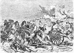
The Battle of Grahovac took place in the eponymous village from 28 April to 1 May 1858, when the Grand Duke Mirko Petrović-Njegoš, elder brother of Prince Danilo, led an army of Montenegrins and won a crucial battle against the Ottomans (army of between 7.000 and 13.000). The battle lasted for four days, and resulted in a decisive victory of Montenegro, after which the demarkation of the border between Montenegro and the Ottoman Bosnia Eyalet was finalised.[3] A considerable arsenal of war trophies was captured by Montenegrins following the retreat of the Ottoman army.
Background
On 28 April 1858, Ottoman commander, Hussein Pasha, captured the villages of Vilusi and Grahovo and continued his advance towards Grahovac, a small village located on a plateau elevated slightly above the captured area. The core of Montenegrin resistance was in Grahovac, which was the main bastion of defence of Montenegro according to military plans. This battle was a prelude to the war of 1862 where Montenegro and the Principality of Serbia would briefly fight the Ottoman Empire.
Battle
The fighting itself started on 29 April, early in the morning. The Ottomans attacked Grahovac while Montenegrins were stubbornly defending, determined not to retreat at any cost. Most of 3,000 Ottoman and 1,000 Montengrin casualties were made on that day. On 30 April, Hussein Pasha offered a truce to Montenegrin commander-in-chief Grand Duke Mirko Petrović-Njegoš refused it, although he did allow the Ottomans time to bury their dead. He also refused to send men to disrupt the Ottomans supply of water. Although this would have given him a tactical advantage he considered it a dishonorable move.
On 1 May, the fighting started again as the Ottomans got military support from Bosnia. But this time, Montenegrins took charge and attacked the Ottomans, forcing them into a successive retreat. The biggest problem for Montenegrins was a well-armed Ottoman artillery, which was constantly bombarding their positions with cannons. Eventually, Montenegrins decided to charge across the battlefield and take over the cannons. After they saw two of the commanders, Serdar (Count) Đuro Kusovac and priest Luka Jovović, being killed while charging, the rest of the Montenegrin troops, including the guardsmen, began a rapid advance with a shout: "Forward, to avenge our commanders". The offensive was successful, and by capturing Ottoman cannons, Montenegrins had officially won the battle.
Aftermath

This major victory had had even more diplomatic significance. The glory of Montenegrin weapons was soon immortalised in the songs and literature of all the South Slavs, in particular the Serbs in Vojvodina, then part of Austria-Hungary. This Montenegrin victory forced the Great Powers to officially demarcate the borders between Montenegro and Ottoman Empire, de facto recognizing Montenegro's centuries-long independence. Montenegro gained Grahovo, Rudine, Nikšić Župa, more than half of Drobnjaci, Tušina, Uskoci, Lipovo, Upper Vasojevići, and part of Kuči and Dodoši.
Prince Danilo granted all of the battle survivors the "Grahovo medal", and Vojvoda (Duke) Mirko Petrović-Njegoš was proclaimed "Grand Duke of Grahovo". In 1864 King Nicholas I built the Church of the Ascension on the site of Hussein Pasha's headquarters,[2] and in 2008, the Montenegrin government revealed an obelisk which honours the battle and its participants. Both on the church and the obelisk read the same inscription: "The monument to your bravery is Montenegro and its freedom."
References
Sources
- Pavićević, Branko (1990). Danilo I Petrović Njegoš, knjaz crnogorski i brdski, 1851-1860 [Danilo I Petrović-Njegoš, the prince of Montenegro and the Highlands]. Književne novine.
- Pavićević, Branko (2007). Sazdanje crnogorske nacionalne države: 1796-1878 [The Creation of Montenegrin nation state: 1796-1878]. CID.
- Batrićević, Đuro (2010). Obavještajna služba u Grahovačkoj bic [Intelligence in the Battle of Grahovac]. Montenegrina.
See also
Coordinates: 42°41′16″N 18°36′41″E / 42.6878°N 18.6114°E