Batman River
| Batman River | |
|---|---|
 Batman River Dam | |
 | |
| Country | Turkey |
| Basin | |
| River mouth | Tigris (Dicle) |
| Physical characteristics | |
| Length | 115 km (71 mi)[1] |
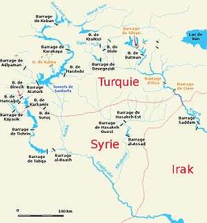
The Batman River is a major tributary of the Tigris, joining it near the source of Tigris called Dicle River in southeast Turkey. It originates in the Anti-Taurus Mountains (at the Sason and Genç mountains)[2] and flows approximately from north to south, passing near the city of Batman and forming a natural border between the Batman Province and Diyarbakır Province. The historic Malabadi Bridge (built in 1146–1147) crosses the river near the town of Silvan.[3] The region along the Batman River is known for its oil fields. The Batman Dam (Turkish: Batman Baraji, B. de Batman on the map) was built in 1999 in the upstream (38°09′36″N 41°12′06″E / 38.160088°N 41.201574°E), together with the associated reservoir and hydroelectric power plant.[4][5]
The river is widest at about 100 metres (330 ft) right after exiting the dam, but then narrows to about 50 metres (160 ft) and forms numerous splits along its way to the Tigris. Its riverbed is irregular in many places, promoting flooding. A tributary of Batman, the Iluh River, originates in the Raman Mountain on the south of the Batman city and flows north-west through the city into the Batman River. Despite being a small river, absent on most maps, Iluh plays an important role for the province because its spring floods affect the provincial capital. The floods of Iluh and Batman rivers occur between March and May and sometimes in October or November. Major floods occurred in 1969 (April, 60 buildings damaged), 1972 (April and May, 210 buildings damaged), 1991 (November, 500 buildings flooded), 1995 (March, nearly 1000 buildings submerged and 450 damaged) and 2006 (October, 11 people died and 20 injured).[2]
In Antiquity, the Batman River was known as Kalat. This name meant "bride" to the Syriac people who populated the area; it was thus translated into Greek as Nymphios (Νυμφίος, Latinized Nymphius) and Nymphaios (Νυμφαῖος, Latinized Nymphaeus).[6] Among Arabs it was known as Satidama, meaning "the bloody" reflecting the battles fought near it.[7] The river served as a natural border between the Byzantine Empire and Sassanid Persia and saw major battles in 583 and 591 AD. The main citadel on the river was Martyropolis, modern Silvan.[8][9]
In international literature, the name Batman came into use since the 19th century,[10] whereas in the 18th century and before it was mostly referred to as Nymphius, among other names.[11][12][13] The origin of the name "Batman" is unclear: it might be a shortening of the name of the 1,228-metre (4,029 ft) tall Bati Raman mountain located nearby[14] or refer to the unit of weight used in the Ottoman Empire.
References
| Wikimedia Commons has media related to Batman River. |
- ↑ Batman Genel Bilgileri Archived May 20, 2011, at the Wayback Machine. (Batman General Information), batman.gov.tr, 29.08.2008 (in Turkish)
- 1 2 Balaban, Meltem Şenol Risk society and planning: the case of flood disaster management in turkish cities. PhD Thesis. Graduate School of Natural and Applied sciences, Middle East Technical University 2009, pp. 147–149, 157
- ↑ Batman. Coğrafya, kultur.gov.tr, 21 February 2007 (in Turkish)
- ↑ Batman Dam. structurae.de
- ↑ Batman Dam Archived July 2, 2014, at the Wayback Machine.. General Directorate of State Hydraulic Works, Turkey
- ↑ Two essays on the geography of ancient Asia: intended partly to illustrate the campaigns of Alexander, and the Anabasis of Xenophon. J. Murray. 1829. pp. 277–.
- ↑ Walter Emil Kaegi (2003). Heraclius: emperor of Byzantium. Cambridge University Press. pp. 131–. ISBN 978-0-521-81459-1.
- ↑ Gordon Douglas Young; American Oriental Society. Middle West Branch; Society of Biblical Literature. Mid-West Region (1992). Mari in retrospect: fifty years of Mari and Mari studies. Eisenbrauns. pp. 10–. ISBN 978-0-931464-28-7.
- ↑ Nymphius (Batman)
- ↑ Two essays on the geography of ancient Asia: intended partly to illustrate the campaigns of Alexander, and the Anabasis of Xenophon. J. Murray. 1829. pp. 262–.
- ↑ Alexander MacBean; Samuel Johnson (1773). A dictionary of ancient geography: explaining the local appellations in sacred, Grecian, and Roman history; exhibiting the extent of kingdoms, and situations of cities, &c. And illustrating the allusions and epithets in the Greek and Roman poets. The whole established by proper authorities, and designed for the use of schools. G. Robinson. pp. 387–.
- ↑ George Sale; George Psalmanazar; Archibald Bower; George Shelvocke; John Campbell; John Swinton (1748). An Universal history, from the earliest account of time. Printed for T. Osborne. pp. 618–.
- ↑ Christoph Cellarius (1706). Notitia orbis antiqui, sive Geographia plenior, ab ortu rerumpublicarum ad Constantinorum tempora. pp. 453–.
- ↑ Ankara Üniversitesi. Tarih Araştırmaları Enstitüsü (1982). Tarih araştırmaları dergisi. Ankara Üniversitesi Basımevi. p. 415. Retrieved 11 February 2011.
Coordinates: 37°47′N 41°01′E / 37.783°N 41.017°E
| Countries | 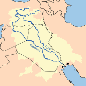 | |
|---|---|---|
| Cities | ||
| Tributaries |
| |
| Dams | ||