Batignolles

Batignolles is a neighborhood of Paris, a part of the 17th arrondissement of the city. The neighborhood is bounded on the south by the Boulevard des Batignolles, on the east by the Avenue de Clichy, on the north by the Rue Cardinet, and on the west by the Rue de Rome.
History
Batignolles was an independent village outside Paris until 1860, when the emperor, Napoleon III, annexed it to the capital.
During the 19th century, Batignolles had an active cultural life, and it served as a base for the painter, Édouard Manet, and his friends, who became known as the "groupe des Batignolles". They painted many scenes of its café life.
Batignolles today
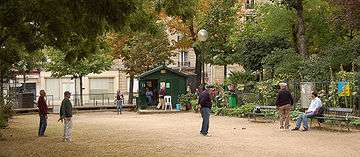
Batignolles is outside the center of Paris most visited by tourists, but attractions include the Batignolles Cemetery and the Square des Batignolles, a small park created in 1862.
Batignolles was supposed to be the Olympic village for the Paris Olympic Games in 2012, but Paris lost its bid to London. In its place, ancient SNCF rail fallows are redeveloped into a new 4.3-hectare district[1] centered on new Martin Luther King garden. By 2015, is it foreseen that 3,400 apartments, 30,000 square meters of shops, 140,000 square meters of office buildings and many public facilities (school, nursery...). will be completed. Moreover the Palais de Justice court, along with the Police judiciaire (Quai des Orfèvres), currently located in the Île de la Cité in central Paris, will move to the new Cité judiciaire de Paris in a new building north of the garden.
This neighbourhood has also given its name to Batignolles Cemetery, which is located in the nearby Épinettes district.
Metro stations
Batignolles is:
| Located near the Métro stations: La Fourche, Rome and Brochant. |
It is served by lines 2 and 13.
![]()
![]()
Education
The Szkoła Narodowa Polska w Paryżu (Polish school in Paris) is in the Batignolles area.
Notes
- ↑ Archived January 27, 2012, at the Wayback Machine.
Coordinates: 48°53′15″N 2°19′15″E / 48.88750°N 2.32083°E