Batesville, Mississippi
| Batesville, Mississippi | |
|---|---|
| City | |
|
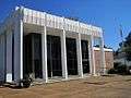
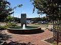
Panola County Courthouse in Batesville | |
 Location of Batesville, Mississippi | |
 Batesville, Mississippi Location in the United States | |
| Coordinates: 34°19′4″N 89°56′33″W / 34.31778°N 89.94250°WCoordinates: 34°19′4″N 89°56′33″W / 34.31778°N 89.94250°W | |
| Country | United States |
| State | Mississippi |
| County | Panola |
| Government | |
| • Type | Mayor-Counsel |
| • Mayor | Jerry Autrey (Democratic Party) |
| • Alderman-at-Large/Vice Mayor | Teddy Morrow |
| • Ward 1 Alderman | Bill Duggar |
| • Ward 2 Alderman | Ted Stewart |
| • Ward 3 Alderman | Stan Harrison |
| Area | |
| • Total | 11.1 sq mi (28.9 km2) |
| • Land | 11.1 sq mi (28.9 km2) |
| • Water | 0.0 sq mi (0.0 km2) |
| Elevation | 233 ft (71 m) |
| Population (2010)[1] | |
| • Total | 7,463 |
| • Density | 670/sq mi (260/km2) |
| Time zone | Central (CST) (UTC-6) |
| • Summer (DST) | CDT (UTC-5) |
| ZIP code | 38606 |
| Area code(s) | 662 |
| FIPS code | 28-03620 |
| GNIS feature ID | 0666568 |
| Website | City website |
Batesville is a city in Panola County, Mississippi. The population was 7,463 at the 2010 census.
Batesville is one of two county seats which the legislature established for Panola County, related to a longstanding rivalry between towns on either side of the Tallahatchie River; the other is Sardis, located north of the river.
Batesville was founded in the 1850s following the construction of the Mississippi and Tennessee Railroad.[2]
Geography
According to the United States Census Bureau, the city has a total area of 11.1 square miles (29 km2), all land.
Demographics
| Historical population | |||
|---|---|---|---|
| Census | Pop. | %± | |
| 1870 | 227 | — | |
| 1880 | 442 | 94.7% | |
| 1890 | 705 | 59.5% | |
| 1900 | 556 | −21.1% | |
| 1910 | 774 | 39.2% | |
| 1920 | 1,050 | 35.7% | |
| 1930 | 1,062 | 1.1% | |
| 1940 | 1,815 | 70.9% | |
| 1950 | 2,463 | 35.7% | |
| 1960 | 3,284 | 33.3% | |
| 1970 | 3,796 | 15.6% | |
| 1980 | 5,162 | 36.0% | |
| 1990 | 6,403 | 24.0% | |
| 2000 | 7,113 | 11.1% | |
| 2010 | 7,463 | 4.9% | |
| Est. 2015 | 7,385 | [3] | −1.0% |

As of the census[5] of 2000, there were 7,113 people, 2,577 households, and 1,821 families residing in the city. The population density was 638.2 people per square mile (246.3/km²). There were 2,791 housing units at an average density of 250.4 per square mile (96.6/km²). The racial makeup of the city was 56.43% White, 41.88% African American, 0.06% Native American, 0.38% Asian, 0.04% Pacific Islander, 0.82% from other races, and 0.39% from two or more races. Hispanic or Latino of any race were 1.60% of the population.
There were 2,577 households out of which 35.7% had children under the age of 18 living with them, 44.7% were married couples living together, 21.5% had a female householder with no husband present, and 29.3% were non-families. 26.2% of all households were made up of individuals and 12.6% had someone living alone who was 65 years of age or older. The average household size was 2.59 and the average family size was 3.14.
In the city the population was spread out with 28.9% under the age of 18, 11.6% from 18 to 24, 26.4% from 25 to 44, 18.6% from 45 to 64, and 14.4% who were 65 years of age or older. The median age was 33 years. For every 100 females there were 85.9 males. For every 100 females age 18 and over, there were 78.4 males. The median income for a household in the city was $29,875, and the median income for a family was $38,849. Males had a median income of $30,998 versus $22,029 for females. The per capita income for the city was $15,814. About 21.9% of families and 28.7% of the population were below the poverty line, including 36.1% of those under age 18 and 27.0% of those age 65 or over.
Government and infrastructure
The United States Postal Service operates the Batesville Post Office.[6]
Transportation
Rail service is provided by Grenada Railway (formerly Illinois Central Railroad).
Amtrak's City of New Orleans used to provide passenger service, but the train was rerouted to the Delta region in 1995.
The short-lived Batesville Southwestern Railroad was established in Batesville.
Education
South Panola School District (SPSD) operates schools in Batesville and has its headquarters in Batesville.[7] Batesville Elementary School,[8] Batesville Intermediate School,[9] Batesville Middle School,[10] Batesville Junior High School,[11] and South Panola High School serve Batesville.[12]
A private academy founded in 1987, North Delta School, also serves Panola County and the surrounding area.[13]
Notable people
- Al Baker – former Major League Baseball player.
- Cliff Finch – governor of Mississippi from 1976 to 1980
- Joe Gardner – Mississippi state legislator
- Peria Jerry – University of Mississippi and Atlanta Falcons defensive tackle
- Ronnie Musgrove – governor of Mississippi from 2000 to 2004, was born in Tocowa in 1956 and reared in Batesville.
- Dwayne Rudd – former NFL player for the Minnesota Vikings, Tampa Bay Buccaneers, Oakland Raiders, and Cleveland Browns.
- Deshea Townsend – Pittsburgh Steelers defensive back
- Wesley Walls – former NFL for the San Francisco 49ers, New Orleans Saints, Carolina Panthers
- Sammy Vick – former Major League Baseball player
- Soulja Boy - hip hop musician & producer, businessman.
References
| Wikimedia Commons has media related to Batesville, Mississippi. |
- ↑ "2010 City Population and Housing Occupancy Status". U.S. Census Bureau. Archived from the original on July 21, 2011. Retrieved May 14, 2012.
- ↑ Kyle, John W. (1913). Reconstruction in Panola County. Publications of the Mississippi Historical Society. XIII. Mississippi Historical Society. p. 13.
- ↑ "Annual Estimates of the Resident Population for Incorporated Places: April 1, 2010 to July 1, 2015". Retrieved July 2, 2016.
- ↑ "Census of Population and Housing". Census.gov. Archived from the original on May 11, 2015. Retrieved June 4, 2015.
- ↑ "American FactFinder". United States Census Bureau. Archived from the original on 2013-09-11. Retrieved 2008-01-31.
- ↑ "Post Office Location – BATESVILLE." United States Postal Service. Retrieved on October 21, 2010.
- ↑ "SPSD Contact Information Archived July 23, 2011, at the Wayback Machine.." South Panola School District. Retrieved on October 21, 2010.
- ↑ "Batesville Elementary School Archived July 1, 2010, at the Wayback Machine.." South Panola School District. Retrieved on October 21, 2010.
- ↑ "Batesville Intermediate School Archived July 22, 2010, at the Wayback Machine.." South Panola School District. Retrieved on October 21, 2010.
- ↑ "Welcome to Batesville Middle School! Archived July 23, 2011, at the Wayback Machine.." South Panola School District. Retrieved on October 21, 2010.
- ↑ "Welcome to Batesville Jr. High! Archived August 29, 2010, at the Wayback Machine." South Panola School District. Retrieved on October 21, 2010.
- ↑ "South Panola High School." South Panola School District. Retrieved on October 21, 2010.
- ↑ North Delta School Archived December 2, 2011, at the Wayback Machine., official website
External links
Gallery


Municipalities and communities of Panola County, Mississippi, United States | ||
|---|---|---|
| City | 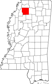 | |
| Towns | ||
| Village | ||
| Unincorporated communities | ||
| Ghost town | ||
| Footnotes | ‡This populated place also has portions in an adjacent county or counties | |