Batangan Peninsula
The Ba Làng An Peninsula (Vietnamese: mũi Ba Làng An, literally "land nose of Three Villages called An") is a peninsula in Vietnam. Ba Làng An is located in Quảng Ngãi Province, northeast of Quảng Ngãi and 32 km south of Chu Lai. The name was often mispronounced as "Ba Tang An" and known as Batangan during the Vietnam War, although Far Eastern Economic Review and other sources continued to refer to the "Ba Lang An peninsula."[1]
History
The "Three Villages called An" which give the name to the peninsula are Vân An, An Chuẩn, and An Hải. The term "ba làng" is native Vietnamese language for "three villages," while the three villages themselves have the usual Sino-Vietnamese names used by Confucian tax-collectors. The Sino-Vietnamese character "An" 安 means "peace," so the villages are sometimes called "Three Villages of Peace".[2]
French Indochina
During the colonial period the waters off the peninsular were recognised as rich fishing grounds. In Nos richesses coloniales 1900-1905 (1906) the cape was called Cap Batangan in French.[3] A French agricultural review (1935) commented that the land of the peninsula was relatively fertile.[4]
The Vietnam War
Since 1963 the Vietcong converted the Peninsula into a fortified stronghold. Following the conclusion of Operation Starlite, on 24 August 1965, Marine intelligence concluded that the 1st VC Regiment had withdrawn into the Peninsula. Reconnaissance photos of the Peninsula showed a V of older field fortifications pointing inland with the open end to the sea and a new second V further inland under construction.[5]
Operation Piranha
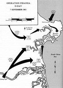
The Marines, Army of the Republic of Vietnam and Vietnamese Marines conducted Operation Piranha on the peninsula from 7–10 September 1965. The operation resulted in 178 Vietcong killed and 360 enemy and suspected enemy had been captured. Allied losses were two Marines and five South Vietnamese killed.[5]:84–8
The Peninsula later became part of the Tactical Area of Responsibility of the Korean 2nd Marine Brigade in 1966 and then the Americal Division, however despite periodic operations the area remained a Vietcong stronghold.
Operations Bold Mariner and Russell Beach
The Marines conducted Operation Bold Mariner on the peninsula from 13 January to 7 February 1969. The Marine assault linked up with Operation Russell Beach conducted by the Americal Division’s Task Force Cooksey, composed of elements of the 46th Infantry Regiment and 1st Cavalry Regiment and the ARVN 2nd Division to seal off the southern boundary. The Marines evacuated numerous civilians for screening, eventually totaling some 11,900 people.[6] Following the conclusion of the assault phase, Operation Russell Beach continued with Marine combined action teams, the 46th Infantry Regiment and the ARVN 6th Regiment operating to cleanse the peninsula of VC/NVA. The population was largely removed from the peninsula during the assault phase and a clear and search operation was followed by the construction of new roads and hamlets. The population was allowed to return in April 1969 together with South Vietnamese government institutions[6]:125
In March 1970, a patrol from the 1st Battalion, 6th Infantry Regiment walked into a minefield on the Peninsula. The battalion commander, LT COL Norman Schwarzkopf, Jr. flew there in his command helicopter and walked into the minefield to rescue a wounded soldier.[7]
Allegations
North Vietnamese sources (1969) made allegations of American use of gas against civilians during mopping up operations.[8] These were discussed in the French Senate in 1969. The village of My Lai, scene of the My Lai Massacre is situated to the southwest of the Peninsula.
Agriculture and Tourism
The Ba Làng An Peninsula is a rich and productive agricultural region encompassing approximately 48 square km of flat, fertile farmland and rolling hills. Today the beaches of the cape are a centre for tourism and diving.[9]
References
- ↑ Far Eastern Economic Review 1971 "Allegedly, during March 1969 US military units systematically annihilated more than 1,200 civilians from Ba Lang An peninsula, Quang Ngai province. American and Vietnamese troops had swept Ba Lang An from January 13 to February 19, "
- ↑ Earl S. Martin - Reaching the Other Side: The Journal of an American Who ... 1978 - Page 131 "Batangan was the French and American variation of the Vietnamese name Ba Lang An, or the Three Villages of Peace. It was a misnomer of "
- ↑ Nos richesses coloniales 1900-1905 Collection des ouvrages: Louis Laurent, G. Darboux, Edouard Heckel - 1906 p283 "Entre le cap Bantam et le cap Batangan, s'ouvrent quelques baies assez mal protégées, et au large émerge la grande île de Culao-Baj, battue par les houles et les vents, « sentinelle avancée de l'Annam central ». Au sud du cap Batangan, ..."
- ↑ Revue générale des sciences pures et appliquées -1935 v 45 p4 "... le secteur Nord, du cap Lay au cap Tourane est pauvre; la culture du riz y est précaire en raison de la surface considérable qu'occupent les lagunes et les dunes anciennes; le second secteur, du cap de Tourane au cap Batangan est un peu plus fertile que le.
- 1 2 Johnson, Charles (1978). U.S. Marines in Vietnam: The Landing and the Buildup, 1965 (Marine Corps Vietnam Operational Historical Series). Marine Corps Association. p. 84. ISBN 978-0-89839-259-3.
- 1 2 Smith, Charles (1988). U.S. Marines in Vietnam High Mobility and Standdown 1969. History and Museums Division, Headquarters, U.S. Marine Corps. pp. 300–304.
- ↑ "Booknotes It Doesn't Take A Hero". C-Span.
- ↑ Vietnamese Studies - Page 127 1971 "During their mopping-up operations in Ba Lang An peninsula in January and February 1969, US and puppet troops used gas grenades, gas insufflators and sprayers against civilian shelters. During a sweep in Thang Binh district, Quang Nam "
- ↑ haiduongnews Cape lures divers for hidden treasure December 25, 2012 “I had a collection of nearly 3,000 items including dishes, bowls and jars, but it is not an outstanding number as I know many divers who own even more significant treasures.”
![]() This article incorporates public domain material from websites or documents of the United States Marine Corps.
This article incorporates public domain material from websites or documents of the United States Marine Corps.
Coordinates: 15°13′10.6″N 108°54′47″E / 15.219611°N 108.91306°E