Bata Airport
| Bata Airport | |||||||||||||||
|---|---|---|---|---|---|---|---|---|---|---|---|---|---|---|---|
.jpg) | |||||||||||||||
| IATA: BSG – ICAO: FGBT | |||||||||||||||
| Summary | |||||||||||||||
| Airport type | Public | ||||||||||||||
| Operator | Aeropuertos De Guinea Ecuatorial (ADGE) | ||||||||||||||
| Location | Bata, Equatorial Guinea | ||||||||||||||
| Elevation AMSL | 13 ft / 4 m | ||||||||||||||
| Coordinates | 1°54′15″N 9°48′15″E / 1.90417°N 9.80417°ECoordinates: 1°54′15″N 9°48′15″E / 1.90417°N 9.80417°E | ||||||||||||||
| Map | |||||||||||||||
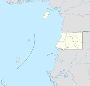 BSG Location of airport in Equatorial Guinea | |||||||||||||||
| Runways | |||||||||||||||
| |||||||||||||||
Bata Airport (IATA: BSG, ICAO: FGBT) is an airport serving Bata in Litoral Province, Equatorial Guinea. It is the second largest airport in Equatorial Guinea, after Malabo Airport.
Overview

The airport is 4 kilometres (2.5 mi) north of Bata and 3.8 kilometres (2.4 mi) south of Utonde. It has a 2440 metre runway that operates only during the daytime and in good light. The state carrier and four other private companies make up the majority of Bata's industry, transporting passengers from Bioko's Malabo International Airport or the airports at Annobón or Mongomo. The airport is large enough to accommodate a Boeing 737. Bata served 15,000 passengers in 2001.
The Bata VOR-DME (ident: BTA) and the Bata non-directional beacon (ident: BT) are located on the field.[3]
In July 2002, all staff at the airport were arrested for allowing the leader of the Popular Union, an opposition party, to board a flight to Gabon.
Airlines and destinations
| Airlines | Destinations |
|---|---|
| CEIBA Intercontinental | Annobón, Douala, Libreville, Malabo |
| Cronos Airlines | Cotonou, Douala, Malabo |
| Guinea Ecuatorial Airlines | Malabo |
See also
 Aviation portal
 Africa portal
- List of airports in Equatorial Guinea
- Transport in Equatorial Guinea
References
- ↑ Airport information for BSG at Great Circle Mapper.
- ↑ Google Maps - Bata
- ↑ SkyVector Aeronautical Charts - Bata