Bastanès
| Bastanès | |
|---|---|
|
The main street | |
 Bastanès | |
|
Location within Nouvelle-Aquitaine region  Bastanès | |
| Coordinates: 43°20′55″N 0°46′09″W / 43.3486°N 0.7692°WCoordinates: 43°20′55″N 0°46′09″W / 43.3486°N 0.7692°W | |
| Country | France |
| Region | Nouvelle-Aquitaine |
| Department | Pyrénées-Atlantiques |
| Arrondissement | Oloron-Sainte-Marie |
| Canton | Navarrenx |
| Intercommunality | Canton de Navarrenx |
| Government | |
| • Mayor (2014–2020) | Thierry Gère |
| Area1 | 5.26 km2 (2.03 sq mi) |
| Population (2010)2 | 102 |
| • Density | 19/km2 (50/sq mi) |
| Time zone | CET (UTC+1) |
| • Summer (DST) | CEST (UTC+2) |
| INSEE/Postal code | 64099 / 64190 |
| Elevation |
99–265 m (325–869 ft) (avg. 135 m or 443 ft) |
|
1 French Land Register data, which excludes lakes, ponds, glaciers > 1 km² (0.386 sq mi or 247 acres) and river estuaries. 2 Population without double counting: residents of multiple communes (e.g., students and military personnel) only counted once. | |

Bastanès is a French commune in the Pyrénées-Atlantiques department in the Nouvelle-Aquitaine region of south-western France.[1]
Geography
Bastanès is in the former province of Béarn some 12 km east by south-east of Sauveterre-de-Béarn and some 13 km south of Orthez. Access to the commune is by the D947 road from Loubieng in the north which passes south-east through the western part of the commune and the village and continues south-east to Navarrenx. The D27 branches off the D947 near the village and goes north-west to Bugnein. The commune is mainly farmland in the south-west with the rest mixed forest and farmland.[2][3]
The Gave d'Oloron forms the south-western border of the commune as it flows north-west to join the Gave de Pau at Peyrehorade. The Saleys river forms the north-eastern border of the commune as it flows north-west to eventually join the Gave d'Oloron east of Saint-Pé-de-Léren. The Barthes stream rises just east of the village and flows north-west to join the Gave d'Oloron at Audaux. The Hérre river rises in the east of the commune and flows north-west to join the Saleys east of Castetbon.[2][3]
Places and hamlets[3]
- Aresteron
- Banche
- Les Barthes
- Bernadou (ruins)
- Boussaque
- Briscain
- Les Camous
- Caulongue
- Les Coustères
- La Hittau
- Hourquet
- Laberdesque
- Labrenabe
- Lacoste
- Lanusse
- Laplacette
- Lassègue
- Lompré-de-Haut
- Manibelle
- Le Moulin
- La Plaine
- Puyounè
- Ribeton
Mapping
A list of online mapping systems can be displayed by clicking on the coordinates (latitude and longitude) in the top right hand corner of this article.
Neighbouring communes and villages
 |
Bugnein | Sauvelade | | |
| Viellenave-de-Navarrenx | |
Vielleségure | ||
| ||||
| | ||||
| Castetnau-Camblong | Méritein | Ogenne-Camptort |
Toponymy

The commune name in Gascon Occitan is also Bastanès. According to Michel Grosclaude the name comes from the gascon basta meaning "gorse" with an obscure suffix, probably giving "moorish terrain".[4]
The following table details the origins of the commune name and other names in the commune.
| Name | Spelling | Date | Source | Page | Origin | Description |
|---|---|---|---|---|---|---|
| Bastanès | Bastanès | 11th century | Raymond | Marca | Village | |
| Bastenes | 1375 | Raymond | Luntz | |||
| Bastanees | 1385 | Raymond | Notaries | |||
| Bastannes | 1540 | Raymond | Reformation | |||
| Sanctus Laurentius de Bastanès | 1608 | Raymond | Insinuations | |||
| Baftanés | 1750 | Cassini | ||||
| Ba?tanés | 1790 | Cassini1 | ||||
| Bastanez | 1801 | Ldh/EHESS/Cassini | Bulletin des Lois | |||
Sources:
- Raymond: Topographic Dictionary of the Department of Basses-Pyrenees, 1863, on the page numbers indicated in the table. (French)[5]
- Grosclaude: Toponymic Dictionary of communes, Béarn, 2006 (French)[4]
- Cassini: 1750 Cassini Map[6]
- Cassini1: 1790 Cassini Map[7]
- Ldh/EHESS/Cassini: Ldh/EHESS/Cassini database (French)
Origins:
- Marca: Pierre de Marca, History of Béarn.[8]
- Luntz: Contracts retained by Luntz[9]
- Notaries: Notaries of Navarrenx[10]
- Reformation: Reformation of Béarn[11]
- Insinuations: Insinuations of the Diocese of Oloron[12]
History
Paul Raymond noted on page 23 of his 1863 dictionary that in 1385 Bastanès had 28 fires and depended on the bailiwick of Navarrenx.[5]
Administration
| From | To | Name | Party | Position |
|---|---|---|---|---|
| 1995 | 2014 | Jacques Langla | ||
| 2014 | 2020 | Thierry Gère |
(Not all data is known)
Intercommunality
The commune is part of five inter-communal structures:
- the community of communes of the Canton of Navarrenx;
- the AEP association of Navarrenx;
- the energy association of Pyrénées-Atlantiques;
- the tax collection association of Navarrenx;
- the inter-communal association of the gaves and the Saleys.
Demography
In 2010 the commune had 102 inhabitants. The evolution of the number of inhabitants is known from the population censuses conducted in the commune since 1793. From the 21st century, a census of communes with fewer than 10,000 inhabitants is held every five years, unlike larger communes that have a sample survey every year.[Note 1]
| 1793 | 1800 | 1806 | 1821 | 1831 | 1836 | 1841 | 1846 | 1851 |
|---|---|---|---|---|---|---|---|---|
| 203 | 200 | - | 250 | 243 | 287 | 288 | 289 | 275 |
| 1856 | 1861 | 1866 | 1872 | 1876 | 1881 | 1886 | 1891 | 1896 |
|---|---|---|---|---|---|---|---|---|
| 271 | 243 | 230 | 227 | 231 | 231 | 226 | 250 | 243 |
| 1901 | 1906 | 1911 | 1921 | 1926 | 1931 | 1936 | 1946 | 1954 |
|---|---|---|---|---|---|---|---|---|
| 234 | 227 | 211 | 169 | 152 | 147 | 140 | 122 | 129 |
| 1962 | 1968 | 1975 | 1982 | 1990 | 1999 | 2006 | 2010 | - |
|---|---|---|---|---|---|---|---|---|
| 136 | 143 | 132 | 143 | 105 | 97 | 99 | 102 | - |
Sources : Ldh/EHESS/Cassini until 1962, INSEE database from 1968 (population without double counting and municipal population from 2006)

Economy
Economic activity is mainly agricultural - livestock, pastures, and corn. The commuen is included in the Appellation d'origine contrôlée (AOC) of Ossau-iraty
Culture and heritage
Religious heritage
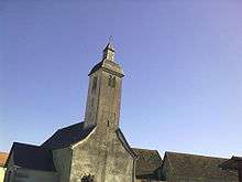
The Parish Church of Saint-Laurent (1860)![]() is registered as an historical monument.[14]
is registered as an historical monument.[14]
Sports
The commune was on the route of the 16th stage of the Tour de France in 2007 on the 25 July. The stage was 218 km from Orthez to the Col d'Aubisque at Gourette.
See also
Notes and references
Notes
- ↑ At the beginning of the 21st century, the methods of identification have been modified by Law No. 2002-276 of 27 February 2002, the so-called "law of local democracy" and in particular Title V "census operations" allows, after a transitional period running from 2004 to 2008, the annual publication of the legal population of the different French administrative districts. For communes with a population greater than 10,000 inhabitants, a sample survey is conducted annually and the entire territory of these communes is taken into account at the end of the period of five years. The first "legal population" after 1999 under this new law came into force on 1 January 2009 and was based on the census of 2006.
References
- ↑ Bastanès on Lion1906
- 1 2 3 Bastanès on Google Maps
- 1 2 3 Bastanès on the Géoportail from National Geographic Institute (IGN) website (French)
- 1 2 Michel Grosclaude, Toponymic Dictionary of communes, Béarn, Edicions reclams & Édition Cairn - 2006, 416 pages, ISBN 2-35068-005-3(French)
- 1 2 Topographic Dictionary of the Department of Basses-Pyrenees, Paul Raymond, Imprimerie nationale, 1863, Digitised from Lyon Public Library 15 June 2011 (French)
- ↑ Baftanés on the 1750 Cassini Map
- ↑ Ba?tanés on the 1790 Cassini Map
- ↑ Pierre de Marca, Histoire de Bearn, La Veuve Jean Camusat, 1640, 850 pages (French)
- ↑ Contracts retained by Luntz, Notary of Béarn, in the Departmental Archives of Pyrénées-Atlantiques (French)
- ↑ Manuscript from the 16th to 18th centuries - Departmental Archives of Pyrénées-Atlantiques (French)
- ↑ Manuscripts from the 17th century in the Departmental Archives of Pyrénées-Atlantiques (French)
- ↑ List of Mayors of France (French)
- ↑ Ministry of Culture, Mérimée IA64000570 Church of Saint-Laurent (French)
| Wikimedia Commons has media related to Bastanès. |