Basque Mountains
| Basque Mountains | |
|---|---|
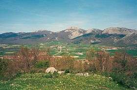
 Alluitz, typical limestone mountain of the Basque range. | |
| Highest point | |
| Peak | Aizkorri |
| Elevation | 1,551 m (5,089 ft) |
| Coordinates | 42°57′N 02°19′W / 42.950°N 2.317°WCoordinates: 42°57′N 02°19′W / 42.950°N 2.317°W |
| Geography | |
| Country | Spain |
| Communities | Basque Country and Navarre |
| Parent range | Cantabrian Range |
| Borders on | Pyrenees |
| Geology | |
| Type of rock | limestone |
The Basque Mountains (Spanish: Montes vascos; Basque: Euskal Herriko arkua, "Basque arc")[1] are a mountain range situated in the northern Iberian Peninsula. Geographically it is considered as the eastern section of the larger Cantabrian Range. The range runs through the Basque Autonomous Community and western Navarre.[2]
Geography
The Basque Mountains are a transitional range between two major ones, the Cantabrian range to the west and the Pyrenees to the east. Geologists call the area "The Basque threshold" and some consider that the Cantabrian Mountains and the Pyrenees are a single greater range and the Basque Mountains are just part of both .
There are two parallel sub-ranges running from west to east, the inner one and the coastal one. In between them there is a 500 m high plateau called "Llanada Alavesa" (Alava Plains) where Vitoria-Gasteiz is located. East of the Llanada a narrow valley called Burunda and its follow-up Barranca (or Sakana in Basque) separate the two ranges, with Urbasa-Andia located to the south and Aralar to the north. The valley harbours major infrastructures linking Vitoria-Gasteiz and Pamplona.
Climate
The Basque coastal range forms the water divide of the Mediterranean and Atlantic basins, the climate north of the range is milder and oceanic, typical of the so-called green Spain, while to the south of the coastal range and in the inner range winters are cold and snowy and summers drier and hotter than in the northern range, in general the climate in the Basque municipalities south of this range is more Mediterranean with some Continental traits, showing less precipitation and much colder winters than those coastal municipalities north of the range.
The snow cover is very irregular during the winter season. From November to April snow cover can be found in the Basque Mountains above 700 m AMSL, but the ever changing weather conditions of the Bay of Biscay can bring great accumulations of snow and a sudden rise of temperatures can melt it in a few days due to the Foehn wind effect. This sudden melting can cause flooding problems, specially in the plains of northern Alava.
Massifs

It is a range of moderate height; Aitxuri (1,551 m) in the Aizkorri massif is the highest peak.
- In the inner range the main massifs from west to east are:
- In the coastal range its main massifs from west to east are:
Nature
The range is almost entirely limestone, but other materials can be found. The slopes are generally gentle, but there are many limestone peaks and cliffs in which vultures dwell. There is abundant oceanic climate vegetation, like beeches, oaks, birches and other like the Cantabrian Holm Oaks and the Pinus radiata, the last one artificially introduced for plantation.
See also
References
- ↑ Eusko Jaurlaritzako Nekazaritza, Arrantza eta Elikadura sailburuaren Agindua, 2007ko abenduaren 12koa, "Euskal Okela" edo "Carne de Vacuno del País Vasco" adierazpen geografiko babestuaren baldintza agiria aldatzeko eskabidearen aldeko ebazpena ematekoa Archived January 13, 2012, at the Wayback Machine.. Official Gazette of the Basque Autonomous Community, no. 76, 2008-04-22.
- ↑ El relieve del Pais Vasco - INGEBA, Instituto Geografico Vasco
External links
| Wikimedia Commons has media related to Mountains of the Basque Country. |