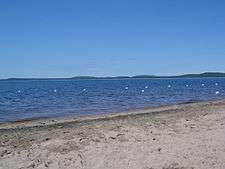
Baskatong Reservoir
| Baskatong Reservoir | |
|---|---|
 Highway 117 is visible in the lower left corner | |
 Location in Quebec | |
| Location | Antoine-Labelle Regional County Municipality / La Vallée-de-la-Gatineau Regional County Municipality, Quebec |
| Coordinates | 46°48′N 75°48′W / 46.800°N 75.800°WCoordinates: 46°48′N 75°48′W / 46.800°N 75.800°W |
| Type | Artificial |
| Primary inflows | Gatineau River |
| Primary outflows | Gatineau River |
| Basin countries | Canada |
| Max. length | 30 km (19 mi) |
| Max. width | 25 km (16 mi) |
| Surface area | 413 km2 (159 sq mi) |
| Max. depth | 96 m (315 ft) |
| Shore length1 | 2,800 km (1,700 mi) |
| Surface elevation | 207 m (679 ft) - 223 m (732 ft)[1] |
| Islands | over 160 |
| Settlements | Grand-Remous |
| References | [1] |
| 1 Shore length is not a well-defined measure. | |
The Baskatong Reservoir (French: Réservoir Baskatong) is a man-made lake in western Quebec, Canada. It was formed following the construction of the Mercier Dam in 1927[2] and has an area of 413 km2.[3] Since 2007, a 55 MW generating station is in operation at the site of the dam, the reservoir also being used to control the flow of the Gatineau River for several hydroelectric generating stations downstream.
Its primary source is the Gatineau River. Other significant sources are:
- Gens de Terre River
- Notawassi River
- Rivière d'Argent
Baskatong Reservoir is accessible by several short forest roads off Route 117, about 200 km (124 mi) north of Ottawa, and about 290 km (180 mi) north-west from Montreal.
Fish species
Baskatong Reservoir is a popular location for fishing and has over 20 outfitters established on its shores. Fish species present are walleye, northern pike, lake trout, whitefish, and landlocked salmon.[4]
See also
References
- 1 2 Ottawa River Regulation Planning Board - Principal Reservoirs Current Water Levels and System Constraints
- ↑ Baskatong Reservoir - Communal Fauna Area Archived February 22, 2007, at the Wayback Machine.
- ↑ Hydro-Québec - Baskatong Reservoir Archived September 27, 2007, at the Wayback Machine.
- ↑ Baskatong outfitters association Archived April 26, 2007, at the Wayback Machine.
External links
| Provinces |
|
|---|---|
| Territories | |
| |