Barun Valley
| Barun valley (Chukchuwa Upatyaka) | |
| Valley | |
 A place called Nghe within Barun Valley. Nghe in local Sherpa language means a 'Sacred place'. | |
| Country | Nepal |
|---|---|
| Region | Koshi Zone |
| District | Sankhuwasabha |
| Length | 46 km (29 mi) |
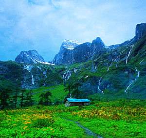
Barun Valley (बरुण उपत्यका) is a Himalayan valley situated at the base of Mt. Makalu in the Sankhuwasabha district Nepal. This valley lies entirely inside the Makalu Barun National Park.
Barun Valley provides stunning contrasts, where high waterfalls cascade into deep gorges, craggy rocks rise from lush green forests, and colorful flowers bloom beneath white snow peaks. This unique landscape shelters some of the last pristine mountain ecosystems on earth. Rare species of animals and plants flourish in diverse climates and habitats, relatively undisturbed by human kind.
History
The valley was created by the Barun River which becomes a glacier in winter. The river is known as Chukchuwa in the local indigenous Kirat language. Study has shown that this place was originally inhabited by Mewahang, Yamfu and Kulung Kirat-Rais centuries ago.[1]
Beyul
In the ancient religious Buddhist books, seven Beyul ( Nghe-Beyul Khimpalung) situated in the Himalayan region are described as mystical and spectacularly beautiful evergreen places where no one gets old. It is told that, in case of great cataclysm, life will remain only in these seven areas of the world. In those books one of the Beyul is mentioned to be situated somewhere at this Makalu-Barun region.[1]
Places

All the area of this valley is uninhabited. It is mostly covered by grassland (Kharka). In the summer, some temporary camps are made. Listed below are the names of these camping regions.
Flora and fauna
Barun Valley climbs from Eastern Himalayan broadleaf forests at low elevations through Eastern Himalayan subalpine conifer forests and into Eastern Himalayan alpine shrub and meadows.
Recognized for its tremendous diversity of plants, animals and people, the area contains over 3,000 species of flowering plants, including 25 species of rhododendron, 47 types of orchids, and 56 rare plants. 440 species of birds, and 75 species of mammals, including the endangered clouded leopard (Snow leopard), red panda, musk deer, wild boar, have been recorded.
This remarkable biodiversity is considered to be of global significance, and provides a living laboratory for international scientific research. The Barun Valley is part of a huge international protected area under an agreement between Nepal and China.
Plants like Swertia Barunensis (4200m) and Potentilla Makaluensis (4000 m) nomenclatured under the name of river Barun and Mt. Makalu are found only in this area in the entire world. 87 himalayan medical herbs including Yarsa Gumba and Panch Aule are found here. Panch Aule is a fingered root plant (five fingers max) where fingers indicate the age of the plant in year.
The trek
This valley lies along the trekking route to Makalu Base Camp. This somewhat difficult yet extremely rewarding trek offers a true wilderness experience in the rugged uninhabited terrain of Makalu-Barun National Park. Because there are no lodges above Tashigaon one needs to take camping gear and enough food and fuel for at least two weeks. The use of a local guide is strongly recommended, as the trails are hard to follow.
Other Attractions
Shiva Dhara (शिव धारा)
This domelike cave, about 500 feet high, has a large waterfall coming out of its stone roof. The waterfall is considered one of the most sacred tape of Lord Shiva. To get to this place one has to climb an extremely dangerous cliff with the help of locals, which will take about three to four hours.
Tadasho
This is a large stone cliff which has a hole in its face, and through which a waterfall cascades. Local legend has it that a dark lake lay atop the cliff, which mysteriously caused the deaths of many Tibetan refugees after nightfall. A Buddhist monk by the name of Rinpoche broke the cliff with his Tadasho, in order to destroy the lake and save the lives of the Tibetan refugees.
See also
References
External links
- Makalu Barun National Park and Conservation Area (Government of Nepal)
- Down to Barun Valley - Travel log
- makalu base camp trek
Coordinates: 27°46′N 87°09′E / 27.767°N 87.150°E