Barton, Australian Capital Territory
| Barton Canberra, Australian Capital Territory | |||||||||||||
|---|---|---|---|---|---|---|---|---|---|---|---|---|---|
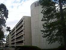
.jpg) Hotel Kurrajong | |||||||||||||
 | |||||||||||||
| Coordinates | 35°18′28″S 149°08′04″E / 35.30778°S 149.13444°ECoordinates: 35°18′28″S 149°08′04″E / 35.30778°S 149.13444°E | ||||||||||||
| Population | 1,183 (2011 census)[1] | ||||||||||||
| • Density | 425/km2 (1,100/sq mi) | ||||||||||||
| Established | 1922 | ||||||||||||
| Gazetted | 20 September 1928 | ||||||||||||
| Postcode(s) | 2600 | ||||||||||||
| Area | 2.21 km2 (0.9 sq mi) | ||||||||||||
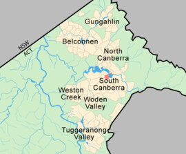
| District | South Canberra | ||||||||||||
| Territory electorate(s) | Kurrajong | ||||||||||||
| Federal Division(s) | Canberra | ||||||||||||
| |||||||||||||
Barton (postcode: 2600) is a suburb of Canberra, Australian Capital Territory, Australia. On Census night 2011, Barton had a population of 1,183 people.[1] Barton is the most Socio-Economic advantaged location in Australia.[2]
Barton is adjacent to Capital Hill. It contains the Department of Prime Minister and Cabinet, Attorney-General's Department, Department of Foreign Affairs and Trade and several other Commonwealth government departments.
On Kings Avenue is the controversial Edmund Barton Building, which was made a heritage listed building in 2005, but its modernist design has often been criticised.
The boundary of Barton runs along Telopea Park East in the south east. On the east side it surrounds the East Basin of Lake Burley Griffin. In the north east the boundary is Morshead Drive. The boundary continues along Kings Avenue all the way to State Circle. State Circle forms the boundary with Capital Hill to the west. The boundary then extends along the centre of Sydney Avenue, and finally along New South Wales Crescent back to Telopea Park.
History


Settlement of Barton began in 1922. The first stage of the heritage-listed Barton Housing Precinct began in 1926 and 1927. It was named after Sir Edmund Barton, Australia's first Prime Minister in 1928. Streets in Barton are named after Governors.[3]
The following areas are heritage listed:
- The Barton Housing Precinct, bounded by Macquarie and Darling streets and Telopea Park, Batman and Currong streets, excluding Brassey Hotel (separately listed), which was built part of John Sulman’s "initial city" at Kingston prior to the construction of the current city centre. The first houses were constructed between 1926 and 1927 to meet the urgent need for housing for public servants for the opening of the new Parliament House in Canberra in 1927. The precinct also contains privately built houses designed by early local architects Mitchell, Sproule and Oliphant.[4]
- The Brassey Hotel, which was completed in 1927 by the Federal Capital Commission in an American Colonial Revival style. The Heritage Council states that "with its garden setting and axial placement at the end of Belmore Gardens," it makes a "major contribution to the urban environment" of the area.[5]
- The Hotel Kurrajong, which was designed by John Smith Murdoch in the garden pavilion style. It often provided housed politicians, especially from the ALP, for half a century and is particularly noted for being the place of Ben Chifley's death.[6]
- Telopea Park School, which was designed by John Smith Murdoch in 1922 and opened on 11 September 1923 and has had many subsequent extensions and modifications.[7]
- Telopea Park, which was first planted by Thomas Weston in 1923.[8]
The former Patent Office and the Edmund Barton building are outside the jurisdiction of the ACT Heritage Council but are recognised and protected in the Commonwealth Heritage List.[9][10]
Suburb amenities
Barton mainly contains government or national institutions and so has few commercial areas such as shops. Barton contains the ACT Hospice, named Clare Holland House and located at the east end of Lake Burley Griffin. On Blackall Street is St Mark's National Theological Centre, a partner in Charles Sturt University School of Theology.The Australian Centre for Christianity and Culture is located next to St Mark's. The Australian Federal Police College is on Brisbane Avenue. Telopea Park School is on New South Wales Crescent.
Brassey Hotel was named after Sir Thomas Brassey, Governor of Victoria. It was originally a guest house for mid level government officials and for Members of Parliament.[5][11]
The Hotel Kurrajong, favoured by Ben Chifley and the location of his death in 1951, is also located in the suburb.[6][12] It is now occupied by the Australian International Hotel School.
Parks in Barton include Telopea Park, York Park, Bowen Park which is on the south shore of Lake Burley Griffin, and Grevillea Park on the north side of the lake.
Demographics

In the 2011 Census, the population of Barton was 1,183, including 5 (0.4%) Indigenous persons and 753 (63.4%) Australian-born persons. Only 12.5% of dwellings were separate houses (compared to the Australian average of 75.6%) and 4.3% were semi-detached, row or terrace houses (Australian average: 9.9%), while 83.1% were flats, units or apartments (Australian average: 13.6%). 45.2% of the population were professionals, compared to the Australian average of 21.3%. Notably 30.1% worked in government administration, compared to the Australian average of 1.3% and the Canberra-wide average of 20.1%. The median weekly personal income for people aged 15 years was $1,473, compared to the median Australian income of $577. Barton is favoured by young adults with 26.5% of its population in the 25- to 34-year-old age group (compared to the Australian average of 13.8%). The suburb has few children under 15: 8.0%, compared to 19.3% Australia-wide. 38.8% of the dwellings are occupied by single person households, compared to the Australian average of 24.3%. 32.3% of the population had no religion, while 19.4% were Catholic and 13.4% were Anglican.[1]
Politics
| |||||||||||||||||||||||||||||||||
Barton is located within the federal electorate of Canberra, which is currently (2016) represented by Gai Brodtmann in the House of Representatives. In the ACT Legislative Assembly, Barton is part of the electorate of Kurrajong, which elects five members on the basis of proportional representation, currently two Labor, two Liberal and one Greens.[15] Polling place statistics are shown to the right for the Barton polling place at Telopea Park School in the 2016 federal[13] and 2016 ACT[14] elections.
Geology
A patch of Ordovician Pittman Formation greywacke outcrops in the south along Canberra Avenue. Silurian Canberra Formation, calcareous Shale is under most of the suburb. Tertiary river gravels are found in the Blackall Street area.[16]
Education
Barton residents get preference for:[17]
- Forrest Primary
- Telopea Park School (for high school)
- Narrabundah College
References
| Wikimedia Commons has media related to Barton, Australian Capital Territory. |
- 1 2 3 Australian Bureau of Statistics (31 October 2012). "Barton (State Suburb)". 2011 Census QuickStats. Retrieved 3 February 2014.
- ↑ 2033.0.55.001 - Census of Population and Housing: Socio-Economic Indexes for Areas (SEIFA), Australia - Data only, 2006 Archived 24 May 2011 at the Wayback Machine.
- ↑ "Place Names". Australian Capital Territory Planning and Land Authority. Retrieved 3 February 2014.
- ↑ "20012. Barton Housing Precinct (Entry to the ACT Heritage Register)" (PDF). ACT Heritage Council. Retrieved 15 March 2014.
- 1 2 "20029. The Brassey Hotel (Entry to the ACT Heritage Register)" (PDF). ACT Heritage Council. Retrieved 15 March 2014.
- 1 2 "20113. Hotel Kurrajong (Entry to the ACT Heritage Register)" (PDF). ACT Heritage Council. 23 February 2005. Retrieved 15 March 2014.
- ↑ "Heritage (Decision about Registration for Telopea Park School, Barton) Notice 2011" (PDF). ACT Heritage Council. 10 March 2011. Retrieved 15 March 2014.
- ↑ "Heritage (Decision about Registration for Telopea Park, Barton) Notice 2012" (PDF). ACT Heritage Council. 23 February 2012. Retrieved 15 March 2014.
- ↑ "Heritage (Decision about Provisional Registration of the Former Patent Office Building, Barton) Notice 2013" (PDF). ACT Heritage Council. 25 July 2013. Retrieved 15 March 2014.
- ↑ "Heritage (Decision about Provisional Registration of the Edmund Barton Building, Barton) Notice 2013" (PDF). ACT Heritage Council. 14 April 2013. Retrieved 15 March 2014.
- ↑ "History". Brassey Hotel. Retrieved 22 January 2007.
- ↑ Minney, Karleen (7 February 2014). "A weekend in your suburb: 36 hours in Barton". The Canberra Times. Fairfax Media. Archived from the original on 7 February 2014.
- 1 2 "Federal Election 2016 - Polling Place Barton". Australian Electoral Commission. 26 July 2016. Retrieved 13 November 2016.
- 1 2 "2016 Results for Kurrajong Candidates at Barton Polling Place". ACT Electoral Commission. 13 November 2016. Retrieved 13 November 2016.
- ↑ "Current members". ACT Legislative Assembly. Retrieved 13 November 2016.
- ↑ Henderson G A M and Matveev G, Geology of Canberra, Queanbeyan and Environs 1:50000 1980.
- ↑ "Priority Enrolment Areas 2015 by Suburb" (Archive). Education Directorate, Australian Capital Territory. Retrieved on February 8, 2016.