Barrett, Texas
| Barrett, Texas | |
|---|---|
| Census-designated place | |
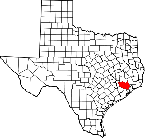
 Location of Barrett, Texas | |
| Coordinates: 29°52′19″N 95°3′43″W / 29.87194°N 95.06194°WCoordinates: 29°52′19″N 95°3′43″W / 29.87194°N 95.06194°W | |
| Country | United States |
| State | Texas |
| County | Harris |
| Area | |
| • Total | 6.5 sq mi (16.9 km2) |
| • Land | 6.5 sq mi (16.8 km2) |
| • Water | 0.1 sq mi (0.2 km2) |
| Elevation | 43 ft (13 m) |
| Population (2010) | |
| • Total | 3,199 |
| • Density | 490/sq mi (190/km2) |
| Time zone | Central (CST) (UTC-6) |
| • Summer (DST) | CDT (UTC-5) |
| ZIP code | 77532 |
| Area code(s) | 281 |
| FIPS code | 48-05696[1] |
| GNIS feature ID | 1372401[2] |
Barrett, also named Barrett Station, is a census-designated place (CDP) in Harris County, Texas, United States. The population was 3,199 at the 2010 census.[3] It was founded in 1889 by Harrison Barrett, a former slave.
Geography
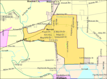
Barrett is located at 29°52′19″N 95°3′43″W / 29.87194°N 95.06194°W (29.871849, -95.062065).[4]
According to the United States Census Bureau, the CDP has a total area of 6.5 square miles (17 km2), of which 6.5 square miles (17 km2) is land and 0.1 square miles (0.26 km2), or 0.92%, is water.
Demographics
As of the census[1] of 2000, there were 2,872 people, 946 households, and 741 families residing in the CDP. The population density was 442.8 people per square mile (170.9/km²). There were 1,034 housing units at an average density of 159.4 per square mile (61.5/km²). The racial makeup of the CDP was 86.56% African American, 8.64% White, 2.89% from other races, and 1.57% from two or more races, 0.35% Native American. Hispanic or Latino of any race were 6.16% of the population.
There were 946 households out of which 35.1% had children under the age of 18 living with them, 47.1% were married couples living together, 25.5% had a female householder with no husband present, and 21.6% were non-families. 18.7% of all households were made up of individuals and 7.1% had someone living alone who was 65 years of age or older. The average household size was 3.03 and the average family size was 3.46.
In the CDP the population was spread out with 29.8% under the age of 18, 8.7% from 18 to 24, 27.6% from 25 to 44, 23.0% from 45 to 64, and 10.9% who were 65 years of age or older. The median age was 34 years. For every 100 females there were 94.2 males. For every 100 females age 18 and over, there were 88.6 males.
The median income for a household in the CDP was $31,343, and the median income for a family was $35,074. Males had a median income of $32,250 versus $20,781 for females. The per capita income for the CDP was $12,333. About 23.1% of families and 23.7% of the population were below the poverty line, including 17.4% of those under age 18 and 33.6% of those age 65 or over.
Education
Barrett residents are zoned to the Crosby Independent School District.
References
- 1 2 "American FactFinder". United States Census Bureau. Archived from the original on 2013-09-11. Retrieved 2008-01-31.
- ↑ "US Board on Geographic Names". United States Geological Survey. 2007-10-25. Retrieved 2008-01-31.
- ↑ "Profile of General Population and Housing Characteristics: 2010 Demographic Profile Data (DP-1): Barrett CDP, Texas". U.S. Census Bureau, American Factfinder. Archived from the original on September 11, 2013. Retrieved June 27, 2012.
- ↑ "US Gazetteer files: 2010, 2000, and 1990". United States Census Bureau. 2011-02-12. Retrieved 2011-04-23.