Barra Mansa
| Barra Mansa, Rio de Janeiro | |||
|---|---|---|---|
| Municipality | |||
 | |||
| |||
 Barra Mansa, Rio de Janeiro | |||
| Coordinates: 22°32′38″S 44°10′15″W / 22.54389°S 44.17083°W | |||
| Country |
| ||
| Region | Southeast | ||
| State | Rio de Janeiro | ||
| Founded | 1832 | ||
| Area | |||
| • Total | 547.23 km2 (211.29 sq mi) | ||
| Elevation | 389 m (1,276 ft) | ||
| Population (2009) | |||
| • Total | 176,889 | ||
| • Density | 320/km2 (840/sq mi) | ||
| Time zone | UTC-3 (UTC-3) | ||
| • Summer (DST) | UTC-2 (UTC-2) | ||
| Postal Code | 27355 | ||
| Area code(s) | +55 24 | ||


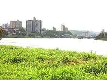
Barra Mansa (Portuguese pronunciation: [ˈbaʁɐ ˈmɐ̃sɐ]) (translation: Gentle [river] Bar) is a municipality located in the Brazilian state of Rio de Janeiro. Its population was 175,328 (2005) and its area is 547 km².[1]
References
- ↑ IBGE - "Archived copy". Archived from the original on 2007-01-09. Retrieved 2014-08-03.
Capital: Rio de Janeiro | |||||||||||||||||||
| Mesoregion Baixadas |
|  | |||||||||||||||||
| Mesoregion Centro Fluminense |
| ||||||||||||||||||
| Mesoregion Metropolitana do Rio de Janeiro |
| ||||||||||||||||||
| Mesoregion Noroeste Fluminense |
| ||||||||||||||||||
| Mesoregion Norte Fluminense |
| ||||||||||||||||||
| Mesoregion Sul Fluminense |
| ||||||||||||||||||
Site Guia de Comercio e Serviços em Barra Mansa - RJ
This article is issued from Wikipedia - version of the 10/27/2016. The text is available under the Creative Commons Attribution/Share Alike but additional terms may apply for the media files.