Barr Trail
| Barr Trail | |
|---|---|
|
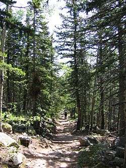
Barr Trail, a couple miles below Barr Camp, downward view, July 2007 | |
| Established | 1918 |
| Length | 13 miles (21 km)[1] |
| Location | Colorado, United States |
| Trailheads |
Manitou Springs, Colorado 38°51′21″N 104°56′02″W / 38.8557°N 104.9339°W Pikes Peak summit 38°50′24″N 105°02′36″W / 38.8400°N 105.0432°WCoordinates: 38°50′24″N 105°02′36″W / 38.8400°N 105.0432°W |
| Use | Hiking |
| Elevation | |
| Elevation gain/loss | 7,390 feet (2,250 m) gain |
| Highest point | 14,115 feet (4,302 m) |
| Hiking details | |
| Website | U.S. Forest Service: Barr Trail |
Barr Trail is a 13-mile (21 km) trail in the Pike National Forest that begins in Manitou Springs, Colorado and ends at the Pikes Peak summit.[1] The high elevation trail with a long sustained grade is rated more difficult by the U.S. Forest Service.[1] With a 7,800 feet (2,400 m) elevation gain to reach the summit, the Colorado Springs Convention & Visitors Bureau states that it is an advanced trail and is the most difficult trail in the Pikes Peak region.[2]
It is used for the Pikes Peak Marathon and the Barr Trail Mountain Race. The 12.6 course for the Barr Trail Mountain Race course starts at the trailhead to Barr Camp and back to the trailhead.[3]
History
A trail was first created by a prospector in the mid-1800s, but the trail did not allow for travel by burro from Mount Manitou to the summit of Pikes Peak. Beginning in 1914, Fred Barr built the burro trail, with a maximum 12% grade to the top of the peak for his burro train business.[1][4] Aside from his work on the major portion of the trail, he supervised a crew of ten men for the U.S. Forest Service in 1917 who built the portion of the trail from the top of the Manitou Incline down to Manitou Springs.[lower-alpha 1] He hiked the entire trail and made it to the top of Pikes Peak on Christmas Eve, 1918.[6]
Barr Camp was built by Barr between 1922 and 1924.[5][6] It was used by Barr and his burro train customers for an overnight stay between Manitou Incline and the summit. Staffed by year-round caretakers, the camp continued to provide overnight accommodations for Barr Trail hikers.[6]
In 1948, the U.S. Forest Service rebuilt the trail, following the original route.[6] Burro trains were used to transport people along the trail until the 1960s.[6]
The 13-mile trail was designated a National Recreation Trail in 1979.[7] It is one of the most frequently used trails in Colorado.[6]
Trail
Points along the trail include:
| Mile | Description | Elevation |
|---|---|---|
| 0 | Trailhead on Ruxton Avenue near the Manitou and Pike's Peak Railway depot, Manitou Springs[1] | 6,707 feet (2,044 m) |
| 6.3[lower-alpha 2] | Barr Camp,[3] 2 acres (8,100 m2) with picnic tables, restrooms[9] cabin, bunkhouse, camping, and meals[10][11] | 10,186 feet (3,105 m)[8] |
| 9 | Open shelter, where campfires may be built[1] | 12,098 feet (3,687 m) |
| 13 | Pikes Peak Summit | 14,118 feet (4,303 m) |
On average, it can take six to ten hours to reach the summit from the trailhead. Many people schedule their hikes and/or overnight stays so that they are on the summit by noon in the summer, with the return trip down the mountain shortly after to avoid the threat of lightning.[2][lower-alpha 3] Other considerations are managing altitude, temperature, and weather changes. For instance, regardless of the season it may be 40 degrees colder on the summit than at the trail head. Another factor is carrying sufficient potable water for the 13 mile hike.[2]
Dogs are allowed on the trails, but bikes are not.[2]
Notes
- ↑ The History for Barr Camp states that Civilian Conservation Corps (CCC) workers completed the lower three miles from the trailhead to the top of Mount Manitou in the 1920s for the Forest Service.[5]
- ↑ The Barr Camp site says that the camp is about 6.5 miles from the trailhead.[8]
- ↑ In 2008, Backpacker magazine said that Barr Trail is one of the countries top 10 most dangerous hikes because of the danger of lightning strikes. They advise that hikers begin to descend from the summit by noon to get below the timberline before there is a threat of a lightning strike.[12]
References
- 1 2 3 4 5 6 "Barr Trail (#620)". U.S. Forest Service. Retrieved January 16, 2015.
- 1 2 3 4 "Barr Trail (Pikes Peak)". Colorado Springs Convention & Visitors Bureau. Retrieved January 16, 2015.
- 1 2 "Home". Barr Trail Mountain Race. Retrieved January 16, 2015.
- ↑ Dr. F.E. Johnson (November 1922). "The Barr Trail" (Google books). Trail and Timberline (50): 7. Retrieved January 16, 2015.
- 1 2 "History". Barr Camp. Retrieved January 16, 2015.
- 1 2 3 4 5 6 "Fred Barr: The Life of the 'Trailmaster of the Rockies'". The Gazette. October 6, 1913. Retrieved January 16, 2015.
- ↑ "Barr Trail". American Trails. Retrieved January 16, 2015.
- 1 2 "Home". Barr Camp. Retrieved January 16, 2015.
- ↑ "Day Use". Barr Camp. Retrieved January 16, 2015.
- ↑ "Overnight". Barr Camp. Retrieved January 16, 2015.
- ↑ "Accommodations". Barr Camp. Retrieved January 16, 2015.
- ↑ Kelly Bastone (October 2008). "America's 10 Most Dangerous Hikes: Barr Trail, Pikes Peak, CO". Backpacker. Retrieved January 16, 2015.
External links
- The Hike, Barr Camp
- The Barr Trail