Barntrup
| Barntrup | ||
|---|---|---|
 | ||
| ||
 Barntrup | ||
Location of Barntrup within Lippe district 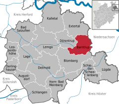
 | ||
| Coordinates: 51°58′59″N 09°07′00″E / 51.98306°N 9.11667°ECoordinates: 51°58′59″N 09°07′00″E / 51.98306°N 9.11667°E | ||
| Country | Germany | |
| State | North Rhine-Westphalia | |
| Admin. region | Detmold | |
| District | Lippe | |
| Government | ||
| • Mayor | Jürgen Schell (non-party) | |
| Area | ||
| • Total | 59.46 km2 (22.96 sq mi) | |
| Population (2015-12-31)[1] | ||
| • Total | 8,846 | |
| • Density | 150/km2 (390/sq mi) | |
| Time zone | CET/CEST (UTC+1/+2) | |
| Postal codes | 32683 | |
| Dialling codes | 05263, 05262 (Alverdissen) | |
| Vehicle registration | LIP | |
| Website |
www | |

Barntrup is a town in the Lippe district of North Rhine-Westphalia, Germany. It has an area of 59.46 km² and 8,824 inhabitants (2013). It lies 40 km east from Bielefeld and 9 km west from Bad Pyrmont at the east border of NRW to Lower Saxony.
Town division
- Alverdissen
- Barntrup
- Selbeck
- Sommersell
- Sonneborn
History
Barntrup and Alverdissen were founded by the Earl of Sternberg in the year 1220. Originally Barntrup was called Barendorf and was a village at the Schratweg. Between 1317 and 1359 Barntrup was built on the highest point of the "Thornesberg" which is 189 m high above sea level. This is the central point of Barntrup.
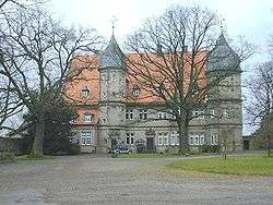
Kerssenbrock Castle (also called Schloss Kerssenbrock or Barntrup Castle, see picture) was constructed from 1584-1588 by Anna von Kerssenbrock (maiden name Anna von Canstein). Her husband, Franz von Kerssenbrock, had been a mercenary in the French Wars of Religion, where he had made much money. The Kerssenbrock family was one of the main noble families in the region.
Education
- Primary school "von-Haxthausen Grundschule" has at this time 420 pupils and 21 teachers.
- High school "Städtisches Gymnasium Barntrup" has about 920 pupils and 50 teachers.
- Junior high school "Hauptschule des Schulverbandes Barntrup-Dörentrup" has about 350 pupils.
Sons and daughters of the town
- Hermann von Kerssenbroch (1519-1585), longtime rector of the High School Paulinum in Münster (Westfalen)
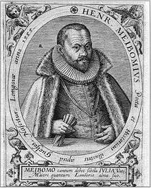
- Heinrich Meibom (1555-1625), poet and historian
- Ludwig Winter (1894, † unknown), politician (NSDAP)
- Ulrich Born (born 1950), lawyer and politician (CDU)
Literature
- Böttcher, Martin und Erika, ed. (1976) (in German), 600 Jahre Barntrup 1376–1976, Barntrup: Lippischer Heimatbund
- Dedo von Kerßenbrock-Krosigk (2009) (in German), Schloss Barntrup (Lippische Kulturlandschaften, Heft 12), Detmold, ISBN 978-3-941726-09-3
- Knese, Louis (1977) (in German), Zauberwahn und Hexenprozesse in Barntrup, Detmold: Lippischer Heimatbund (u. a.)
- Hartwig Walberg; Michael Tönsing (1988), Heinz Stoob; Wilfried Ehbrecht, eds. (in German), Westfälischer Städteatlas, Band: III, 1. Teilband, Altenbeken: GSV-Städteatlas-Verlag, ISBN 3-89115-121-7
References
- ↑ "Amtliche Bevölkerungszahlen". Landesbetrieb Information und Technik NRW (in German). 18 July 2016.
External links
| Wikimedia Commons has media related to Barntrup. |
- Official website (in German)
Towns and municipalities in Lippe | ||
|---|---|---|