Barnsole
| Barnsole | |
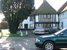 The Black Pig pub, Barnsole |
|
 Barnsole |
|
| OS grid reference | TR2656 |
|---|---|
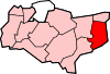
| District | Dover |
| Shire county | Kent |
| Region | South East |
| Country | England |
| Sovereign state | United Kingdom |
| Post town | Canterbury |
| Postcode district | CT3 |
| Police | Kent |
| Fire | Kent |
| Ambulance | South East Coast |
| EU Parliament | South East England |
Coordinates: 51°15′36″N 1°15′54″E / 51.26°N 1.265°E
Barnsole is a village in East Kent, England, between Canterbury and Deal.[1][2] The population of the village is included in the civil parish of Wingham.
It once had a Baptist chapel, linked to the Eythorne Baptist Church "group".
References
- ↑ Ordnance Survey: Landranger map sheet 179 Canterbury & East Kent (Dover & Margate) (Map). Ordnance Survey. 2013. ISBN 9780319228784.
- ↑ "Ordnance Survey: 1:50,000 Scale Gazetteer" (csv (download)). www.ordnancesurvey.co.uk. Ordnance Survey. 1 January 2016. Retrieved 30 January 2016.
External links
![]() Media related to Barnsole at Wikimedia Commons
Media related to Barnsole at Wikimedia Commons
This article is issued from Wikipedia - version of the 9/12/2016. The text is available under the Creative Commons Attribution/Share Alike but additional terms may apply for the media files.