Barlow, Oregon
| Barlow, Oregon | |
|---|---|
| City | |
|
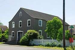
Church in Barlow | |
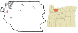 Location in Oregon | |
| Coordinates: 45°15′8″N 122°43′17″W / 45.25222°N 122.72139°WCoordinates: 45°15′8″N 122°43′17″W / 45.25222°N 122.72139°W | |
| Country | United States |
| State | Oregon |
| County | Clackamas |
| Incorporated | 1903 |
| Government | |
| • Mayor | Mike Lundsten |
| Area[1] | |
| • Total | 0.05 sq mi (0.13 km2) |
| • Land | 0.05 sq mi (0.13 km2) |
| • Water | 0 sq mi (0 km2) |
| Elevation | 101 ft (31 m) |
| Population (2010)[2] | |
| • Total | 135 |
| • Estimate (2012[3]) | 137 |
| • Density | 2,700.0/sq mi (1,042.5/km2) |
| Time zone | Pacific (UTC-8) |
| • Summer (DST) | Pacific (UTC-7) |
| ZIP code | 97013 |
| Area code(s) | 503 |
| FIPS code | 41-04000[2] |
| GNIS feature ID | 1166611[4] |
Barlow is a city in Clackamas County, Oregon, United States. The population was 135 at the 2010 census.
History

Barlow is named for William Barlow, the son of Samuel K. Barlow (developer of the Barlow Road). Samuel bought the donation land claim in which Barlow is located from Thomas McKay on September 17, 1850. He later sold the land to William.[5]
In 1870, the railroad was built through Barlow. The station was originally named Barlows (for William, not Samuel). As of 2003, the main line of the Union Pacific Railroad still ran through Barlow.[5]
The post office at Barlow was opened on February 7, 1871. It closed on January 3, 1975.[5]
Geography
According to the United States Census Bureau, the city has a total area of 0.05 square miles (0.13 km2), all of it land.[1]
Demographics
| Historical population | |||
|---|---|---|---|
| Census | Pop. | %± | |
| 1910 | 69 | — | |
| 1920 | 42 | −39.1% | |
| 1930 | 40 | −4.8% | |
| 1940 | 52 | 30.0% | |
| 1950 | 75 | 44.2% | |
| 1960 | 85 | 13.3% | |
| 1970 | 105 | 23.5% | |
| 1980 | 105 | 0.0% | |
| 1990 | 118 | 12.4% | |
| 2000 | 140 | 18.6% | |
| 2010 | 135 | −3.6% | |
| Est. 2015 | 139 | [6] | 3.0% |
2010 census
As of the census of 2010, there were 135 people, 44 households, and 35 families residing in the city. The population density was 2,700.0 inhabitants per square mile (1,042.5/km2). There were 45 housing units at an average density of 900.0 per square mile (347.5/km2). The racial makeup of the city was 80.7% White, 0.7% African American, 0.7% Native American, 14.1% from other races, and 3.7% from two or more races. Hispanic or Latino of any race were 14.8% of the population.[2]
There were 44 households of which 36.4% had children under the age of 18 living with them, 61.4% were married couples living together, 11.4% had a female householder with no husband present, 6.8% had a male householder with no wife present, and 20.5% were non-families. 20.5% of all households were made up of individuals and 11.4% had someone living alone who was 65 years of age or older. The average household size was 3.07 and the average family size was 3.43.[2]
The median age in the city was 38.4 years. 29.6% of residents were under the age of 18; 8.1% were between the ages of 18 and 24; 23% were from 25 to 44; 26.7% were from 45 to 64; and 12.6% were 65 years of age or older. The gender makeup of the city was 48.9% male and 51.1% female.[2]
2000 census
As of the census of 2000, there were 140 people, 40 households, and 33 families residing in the city. The population density was 2,275.8 people per square mile (900.9/km²). There were 41 housing units at an average density of 666.5 per square mile (263.8/km²). The racial makeup of the city was 90.71% White, 0.71% Asian, 3.57% from other races, and 5.00% from two or more races. Hispanic or Latino of any race were 9.29% of the population.[2]
There were 40 households out of which 47.5% had children under the age of 18 living with them, 77.5% were married couples living together, 5.0% had a female householder with no husband present, and 17.5% were non-families. 12.5% of all households were made up of individuals and 7.5% had someone living alone who was 65 years of age or older. The average household size was 3.50 and the average family size was 3.79.[2]
In the city the population was spread out with 32.9% under the age of 18, 8.6% from 18 to 24, 28.6% from 25 to 44, 19.3% from 45 to 64, and 10.7% who were 65 years of age or older. The median age was 34 years. For every 100 females there were 97.2 males. For every 100 females age 18 and over, there were 104.3 males.[2]
The median income for a household in the city was $41,250, and the median income for a family was $46,250. Males had a median income of $35,156 versus $37,917 for females. The per capita income for the city was $14,431. There were 5.4% of families and 3.5% of the population living below the poverty line, including 7.9% of under eighteens and none of those over 64.[2]
See also
References
- 1 2 "US Gazetteer files 2010". United States Census Bureau. Archived from the original on January 24, 2012. Retrieved 2012-12-21.
- 1 2 3 4 5 6 7 8 9 "American FactFinder". United States Census Bureau. Retrieved 2012-12-21.
- ↑ "Population Estimates". United States Census Bureau. Archived from the original on June 17, 2013. Retrieved 2013-06-02.
- ↑ "US Board on Geographic Names". United States Geological Survey. 2007-10-25. Retrieved 2008-01-31.
- 1 2 3 McArthur, Lewis A.; Lewis L. McArthur (2003) [1928]. Oregon Geographic Names (Seventh ed.). Portland, Oregon: Oregon Historical Society Press. pp. 52–53. ISBN 0-87595-277-1.
- ↑ "Annual Estimates of the Resident Population for Incorporated Places: April 1, 2010 to July 1, 2015". Retrieved July 2, 2016.
- ↑ "Census of Population and Housing". Census.gov. Archived from the original on January 1, 1970. Retrieved June 4, 2015.
External links
- Entry for Barlow in the Oregon Blue Book
Municipalities and communities of Clackamas County, Oregon, United States | ||
|---|---|---|
| Cities | 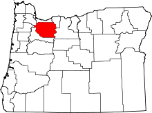 | |
| Hamlets | ||
| CDPs | ||
| Other unincorporated communities |
| |
| Footnotes | ‡This populated place also has portions in an adjacent county or counties | |