| Name | Shape | Elevation | Last eruption (VEI) | Geolocation |
| Weh | stratovolcano | 7002617000000000000♠617 metres (2,024 ft) | -999997412000-01-01-0000Pleistocene | 5°49′N 95°17′E / 5.82°N 95.28°E / 5.82; 95.28 |
| Seulawah Agam | stratovolcano | 7003181000000000000♠1,810 metres (5,940 ft) | 000000001839-01-01-00001839 (2) | 5°26′53″N 95°39′29″E / 5.448°N 95.658°E / 5.448; 95.658 |
| Peuet Sague | complex volcano | 7003280100000000000♠2,801 metres (9,190 ft) | 000000002000-12-25-000025 December 2000 (2) | 4°54′50″N 96°19′44″E / 4.914°N 96.329°E / 4.914; 96.329 |
| Geureudong | stratovolcano | 7003288500000000000♠2,885 metres (9,465 ft) | 000000001937-01-01-00001937 | 4°48′47″N 96°49′12″E / 4.813°N 96.82°E / 4.813; 96.82 |
| Kembar | shield volcano | 7003224500000000000♠2,245 metres (7,365 ft) | -999997412000-01-01-0000Pleistocene | 3°51′00″N 97°39′50″E / 3.850°N 97.664°E / 3.850; 97.664 |
| Sibayak | stratovolcano | 7003221200000000000♠2,212 metres (7,257 ft) | 000000001881-01-01-00001881 | 3°14′N 98°31′E / 3.23°N 98.52°E / 3.23; 98.52 |
| Sinabung | stratovolcano | 7003246000000000000♠2,460 metres (8,070 ft) | 000000002010-09-07-00007 September 2010 | 3°10′12″N 98°23′31″E / 3.17°N 98.392°E / 3.17; 98.392 |
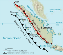
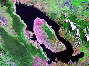
| Toba | supervolcano | 7003215700000000000♠2,157 metres (7,077 ft) | cca 75.000 years ago | 2°35′N 98°50′E / 2.58°N 98.83°E / 2.58; 98.83 |
| Helatoba-Tarutung | fumarole field | 7003110000000000000♠1,100 metres (3,600 ft) | -999997412000-01-01-0000Pleistocene | 2°02′N 98°56′E / 2.03°N 98.93°E / 2.03; 98.93 |
| Imun | unknown | 7003150500000000000♠1,505 metres (4,938 ft) | unknown | 2°09′29″N 98°55′48″E / 2.158°N 98.93°E / 2.158; 98.93 |
| Sibualbuali | stratovolcano | 7003181900000000000♠1,819 metres (5,968 ft) | unknown | 1°33′22″N 99°15′18″E / 1.556°N 99.255°E / 1.556; 99.255 |
| Lubukraya | stratovolcano | 7003186200000000000♠1,862 metres (6,109 ft) | unknown | 1°28′41″N 99°12′32″E / 1.478°N 99.209°E / 1.478; 99.209 |
| Sorikmarapi | stratovolcano | 7003214500000000000♠2,145 metres (7,037 ft) | 000000001986-01-01-00001986 (1) | 0°41′10″N 99°32′20″E / 0.686°N 99.539°E / 0.686; 99.539 |
| Talakmau | complex volcano | 7003291900000000000♠2,919 metres (9,577 ft) | unknown | 0°04′44″N 99°58′48″E / 0.079°N 99.98°E / 0.079; 99.98 |
| Sarik-Gajah | volcanic cone | unknown | unknown | 0°00′29″N 100°12′00″E / 0.008°N 100.20°E / 0.008; 100.20 |
| Marapi | complex volcano | 7003289100000000000♠2,891 metres (9,485 ft) | 000000002004-08-05-00005 August 2004 (2) | 0°22′52″S 100°28′23″E / 0.381°S 100.473°E / -0.381; 100.473 |
| Tandikat | stratovolcano | 7003243800000000000♠2,438 metres (7,999 ft) | 000000001924-01-01-00001924 (1) | 0°25′59″S 100°19′01″E / 0.433°S 100.317°E / -0.433; 100.317 |
| Talang | stratovolcano | 7003259700000000000♠2,597 metres (8,520 ft) | 000000002005-04-12-000012 April 2005 (2) | 0°58′41″S 100°40′44″E / 0.978°S 100.679°E / -0.978; 100.679 |
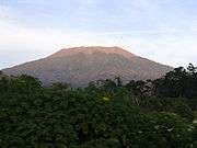
| Kerinci | stratovolcano | 7003380000000000000♠3,800 metres (12,500 ft) | 000000002004-06-22-000022 June 2004 (2) | 1°41′49″S 101°15′50″E / 1.697°S 101.264°E / -1.697; 101.264 |
| Hutapanjang | stratovolcano | 7003202100000000000♠2,021 metres (6,631 ft) | unknown | 2°20′S 101°36′E / 2.33°S 101.60°E / -2.33; 101.60 |
| Sumbing | stratovolcano | 7003250700000000000♠2,507 metres (8,225 ft) | 000000001921-05-23-000023 May 1921 (2) | 2°24′50″S 101°43′41″E / 2.414°S 101.728°E / -2.414; 101.728 |
| Kunyit | stratovolcano | 7003215100000000000♠2,151 metres (7,057 ft) | unknown | 2°35′31″S 101°37′48″E / 2.592°S 101.63°E / -2.592; 101.63 |
| Pendan | unknown | unknown | unknown | 2°49′S 102°01′E / 2.82°S 102.02°E / -2.82; 102.02 |
| Belirang-Beriti | compound | 7003195800000000000♠1,958 metres (6,424 ft) | unknown | 2°49′S 102°11′E / 2.82°S 102.18°E / -2.82; 102.18 |
| Bukit Daun | stratovolcano | 7003246700000000000♠2,467 metres (8,094 ft) | unknown | 3°23′S 102°22′E / 3.38°S 102.37°E / -3.38; 102.37 |
| Kaba | stratovolcano | 7003195200000000000♠1,952 metres (6,404 ft) | 000000002000-08-22-000022 August 2000 (1) | 3°31′S 102°37′E / 3.52°S 102.62°E / -3.52; 102.62 |
| Dempo | stratovolcano | 7003317300000000000♠3,173 metres (10,410 ft) | 000000001994-10-01-0000October 1994 (1) | 4°02′S 103°08′E / 4.03°S 103.13°E / -4.03; 103.13 |
| Patah | unknown | 7003281700000000000♠2,817 metres (9,242 ft) | unknown | 4°16′S 103°18′E / 4.27°S 103.30°E / -4.27; 103.30 |
| Bukit Lumut Balai | stratovolcano | 7003205500000000000♠2,055 metres (6,742 ft) | unknown | 4°14′S 103°37′E / 4.23°S 103.62°E / -4.23; 103.62 |
| Besar | stratovolcano | 7003189900000000000♠1,899 metres (6,230 ft) | 000000001940-04-01-0000April 1940 (1) | 4°26′S 103°40′E / 4.43°S 103.67°E / -4.43; 103.67 |
| Ranau | caldera | 7003188100000000000♠1,881 metres (6,171 ft) | unknown | 4°50′S 103°55′E / 4.83°S 103.92°E / -4.83; 103.92 |
| Sekincau Belirang | caldera | 7003171900000000000♠1,719 metres (5,640 ft) | unknown | 5°07′S 104°19′E / 5.12°S 104.32°E / -5.12; 104.32 |
| Suoh | caldera | 7003100000000000000♠1,000 metres (3,300 ft) | 000000001933-07-10-000010 July 1933 (4) | 5°15′S 104°16′E / 5.25°S 104.27°E / -5.25; 104.27 |
| Hulubelu | caldera | 7003104000000000000♠1,040 metres (3,410 ft) | 000000001836-01-01-00001836 | 5°21′S 104°36′E / 5.35°S 104.60°E / -5.35; 104.60 |
| Rajabasa | stratovolcano | 7003128100000000000♠1,281 metres (4,203 ft) | 000000001798-01-01-00001798 | 5°46′48″S 105°37′30″E / 5.78°S 105.625°E / -5.78; 105.625 |