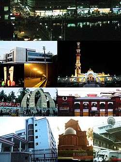
Barisal
| Barisal City বরিশাল বাকলা (Bakla) চন্দ্রদ্বীপ (Chandradeep), | |
|---|---|
| Metropolis | |
| Barisal | |
 | |
| Nickname(s): Venice of the East | |
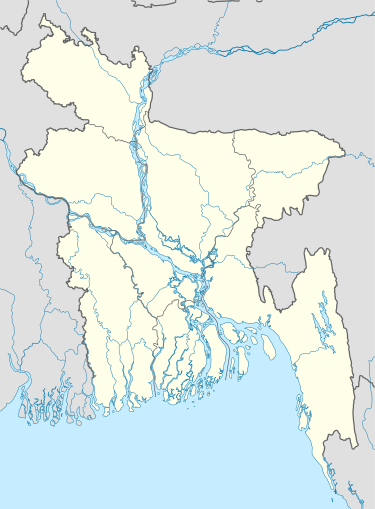 Barisal City Location of Barisal in Bangladesh | |
| Coordinates: 22°48′0″N 90°30′0″E / 22.80000°N 90.50000°E | |
| Country |
|
| Division | Barisal Division |
| District | Barisal District |
| Municipality Eshtablished | 1876 |
| City Corporation | 2002 |
| Granted city status | 19 April 2001 [1] |
| Government | |
| • Type | Mayor–Council |
| • Body | Barisal City Corporation |
| • City Mayor | Ahsan Habib Kamal |
| Area[2] | |
| • Urban | 58 km2 (22 sq mi) |
| Elevation | 1 m (4 ft) |
| Population (2011)[3] | |
| • Metropolis | 328,278 |
| • Density | 10,524/km2 (27,260/sq mi) |
| • Metro | 385,093 |
| Time zone | BST (UTC+6) |
| Postal code | 8200 |
| Calling code | 0431 |
| Website | Official Web Portal |
Barisal (Bengali: বরিশাল Bariśāl; historically Bakla-Chandradwip; also Gird-e-Bandar) is a major city that lies on the bank of Kirtankhola river in south-central Bangladesh. It is the largest city and the administrative headquarter of both Barisal district and Barisal Division. It is one of the oldest municipalities and river ports of the country. Barisal municipality was established in the year 1876 during the British Raj and upgraded to City Corporation on 25 July 2002.[4] The city consists of 30 wards and 50 mahallas with a population of 328,278 according to the 2011 national census. The area of the city is 58 km².[5]
History

Barisal was a semi-independent area in the Mughal period because of heavy fighting between them and Hindu chiefs. In course of time, it fell under the Bengal Nawabs, the last being Raja Nakuleswar Bose and then colonial British India, later passed to East Pakistan at independence and finally Bangladesh.
The central city of this region is the city of Barisal. It is one of the biggest river ports in Bangladesh. It is a city with nearly 0.38 million people and a divisional headquarters, medical college, cadet college, some pharmaceutical industries, textile industries and the Bangladesh Inland Water Transport Authority's head office. Barisal is fast growing city of the country stands on the Kirtankhola River. Country's first short landing and take off airport has been completed in Barisal and a private Airlines named Air Bengal has begun its regular air flight between Dhaka Tejgaon Airport and Barisal.
The city is sometimes called the "Venice of the East" or the "Venice of Bengal".[6]
Geography
Barisal city occupies an area of 58 km2.
Barisal District, with an area of 2790.51 km2, is bounded by Madaripur, Shariatpur, Chandpur and Lakshmipur districts on the north, Patuakhali, Barguna and Jhalokati districts on the south, Bhola and Lakshmipur districts on the east, Jhalokati, Pirojpur and Gopalganj districts on the west. Several rivers flow across Barisal including the Kirtankhola, Arial Khan, Khoyrabad, Kalijira and Sandha.
Climate
Barisal has a tropical wet and dry climate.
| Climate data for Barisal | |||||||||||||
|---|---|---|---|---|---|---|---|---|---|---|---|---|---|
| Month | Jan | Feb | Mar | Apr | May | Jun | Jul | Aug | Sep | Oct | Nov | Dec | Year |
| Average high °C (°F) | 25.6 (78.1) |
28.2 (82.8) |
32.2 (90) |
33.3 (91.9) |
33.0 (91.4) |
31.7 (89.1) |
30.9 (87.6) |
30.9 (87.6) |
31.5 (88.7) |
31.5 (88.7) |
29.6 (85.3) |
26.5 (79.7) |
30.4 (86.7) |
| Average low °C (°F) | 11.9 (53.4) |
14.9 (58.8) |
20.2 (68.4) |
23.6 (74.5) |
24.7 (76.5) |
25.6 (78.1) |
25.5 (77.9) |
25.5 (77.9) |
25.3 (77.5) |
23.6 (74.5) |
18.8 (65.8) |
13.3 (55.9) |
21.1 (70) |
| Average precipitation mm (inches) | 8 (0.31) |
27 (1.06) |
56 (2.2) |
128 (5.04) |
230 (9.06) |
409 (16.1) |
408 (16.06) |
370 (14.57) |
258 (10.16) |
162 (6.38) |
53 (2.09) |
15 (0.59) |
2,124 (83.62) |
| Average precipitation days (≥ 0.1 mm) | 1 | 3 | 3 | 7 | 11 | 18 | 23 | 22 | 16 | 8 | 2 | 0 | 114 |
| Source: WMO[7] | |||||||||||||
Population
Demographics

According to provisional results of the 2011 national census, the population of Barisal (areas under the jurisdiction of the Barisal city corporation) stands at 328,278.[3] By gender, the population was 51.63 male and 48.37 percent female.[5]
The literacy rate among the urban people of Barisal is 75.3%.[8] which is significantly higher than the national average of 56.5%.
Most of the people in Barisal are the Bengali people, as is the case in most of Bangladesh. The long-standing inhabitants of the city are known as Barisaliya and they have a distinctive dialect. Apart from them.The city population is composed of people from neighboring Upazilas and districts (Patuakhali, Bhola, Pirojpur, Jhalakati, Barguna, Madaripur).
Languages
There are four major languages spoken in Barisal
- Standard Bengali, which is the administrative language and thus mainly used in academia and offices.
- Barisali dialect, which is commonly spoken by almost all the native peoples of Greater Barisal region (Barisal Division), is considered as a dialect of Bengali which does not have a written form.
- English, which is held in high esteem and is used by the educated elite.
- Marginalised Bengali, a cocktail language of Northern Bengali dialects spoken by migrant workers such as service holders, domestic servants, rickshaw peddlers and other menial labourers from different parts of Bangladesh living and working in Barisal.
Religion
The majority of Barisal's people are Muslims (89.30%), mainly Sunni Islam Hanafi. Other religious groups include Hindus (9.7%), and very few numbers of other religions, mainly Christians (.98%) and Buddhists (0.01%).[9]
Since end 2015, the Catholic minority has its own Roman Catholic Diocese of Barisal.
Economy
Barisal is a rice producing center of Bangladesh. Balam (a kind of basmati) is the most popular rice in Barisal. It is also famous for Betel Leaf, a typical south Asian chewing item. As Barisal is surrounded by river so fish is plenty in there. A Bengali saying states, "Dhan, nadi, khal ai tine Barisal" which translates to "paddy, river and canal are these three things that make Barisal".
Coconut is a common fruit as the city is located near the coast. Barisal is also known for its hog plum.
Exports: Agricultural products, Hilsha fish, Medicine, Empty Gelatine Capsules, Anchor Cement etc.
Culture
Media
Barisal is a center for the newspaper, periodical and book publishers. Some locally published newspapers and periodicals are:
Newspapers
- Daily Ajker Barta
- Daily Dakkhinanchal
- Daily Shahnama
- Daily Bhorer Alo
- Daily Banglar Bone
- Daily Ajker poribartan
- Daily Barisal Protidin
- Daily Motobad
- Daily Satya Songbad
- Daily Barisal Barta
- Daily Bhorer Angikar
- Daily Biplobi Bangladesh
- Daily Barisal er Ajkal
- Daily Ajker barisal
Source:[10]
Periodicals
- Bakerganj Parikrama
- Chirantan Bangla
- Upakul
- Gournadi Parikrama
- Khadem
Points of interest
-

Durga Sagar in Madhabpasha
-

Shohel Chattar, Bibir Pukur Par
-

Padma Pukur, Barisal
-

Bell's Park aka Bangabandhu Udyan
-

30 Godown Freedom Fighters Monument

Durgasagar: with an area of about 2,500 hectare, is the largest pond or dighi of southern Bangladesh. It is located at Madhabpasa village of babuganj upazila, about 11 km away from Barisal town. Locally it is known as Madhabpasha Dighi. According to a desire of Rani Durgavati, mother of Raja Joynarayan, the dighi was dug in 1780 (1187 BS). There are coconut trees around the dighi which together with the dighi are bounded by brick-walls. In the middle of the dighi, there is an island with bushes. Migratory birds usually come here during winter. The surrounding areas of the dighi has now been turned into a picnic spot. Madhabpasha was a capital of the kingdom of Chandradvipa.
- Durga Sagar
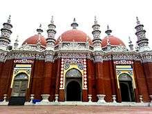
- Baitul Aman Jame Masjid Complex
- Oxford Mission Church
- Bell's Park aka Bangubandhu Udyan
- 30 Godown
- Planet World
- Muktijoddha Park
- Narikel Bagan & Horticulture (Agriculture Training Institute)
- Lakhutia Zamindar Bari
- Korapur Miah Bari Masjid
- Shankar Math
- Town Hall
- Sher-e-Bangla Museum
- Bir Sreshtho Captain Mohiuddin Jahangir Library and Museum
- Jibanananda Das Museum
- Dapdapia Bridge
- Bibir Pukur
- Padma Pukur (Pond of Lotus)
- Kali Mandir founded by the Poet Mukunda Das
- BadhyaBhumi Monument (বধ্যভূমি স্মৃতিসৌধ)
- Bangladesh Rice Research Institute Regional Centre (Coconut Garden)
Architecture
Barisal's buildings are too diverse to be characterised by any particular architectural style, and have been built over a long period of time.
Some well known heritage buildings are:
- Guthia Baitul Aman Jame Mashjid Complex
- Rammohan Samadhi Mandir
- Sujabad Kella
- Sangram Kella
- Sharkal Fort
- Girja Mahalla
- Bangabondhu Uddyan
- Ebadullah Mosque
- Kasai Mosque
- Oxford Mission Church
- Shankar Math
- Kali Bari of Mukunda Das
- Joint Mosque at Bhatikhana
- Aswini kumar town hall
- Charkella
- Durgasagar Dighi
- One domed Mosque (Kasba)
- Fakir Bari jamee Mosjid
- Housing Estate Jame Mosjid
Sports
Cricket and football are the two most popular sports in Barisal while tennis and kabaddi are also popular. There is a national stadium in the city known as Barisal Divisional Stadium (also known as Abdur Rab Serniabad Stadium). It is a multi-purpose stadium and has a capacity of 15,000 spectators. It is currently used mostly for cricket matches. It is also used for football and other sports. Besides different organization share to stage a show there occasionally. Notable players from Barisal who have played for the national team include Sohag Gazi, Shahriar Nafees and Iftekhar Nayem.
There is a regional sports training center under Bangladesh Krira Shiksha Pratisthan (BKSP) situated at Rahamatpur in Barisal[11] Barisal is also home to the Bangladesh Premier League franchise Barisal Bulls.
Transport
Air
Barisal airport is a local airport. Bangladesh Biman and US-Bangla Airlines use that port. Active route is Barisal-Dhaka-Barisal.
River port
Barisal River Port is the second largest river port of Bangladesh. It's the most popular way of communication for the people of Barisal to Dhaka, the capital city. It is also a popular transport system with other districts like Bhola, Barguna, Lakshimipur.
Buses
There are two bus terminals in Barisal, Nathullabad Central Bus terminal and Rupatali Bus Terminal. Many Bus company connect Barisal to other districts.
Education

Barisal is home to many educational institutions. Govt. Brojomohan College is the oldest institution of higher education in the city, founded in 1889. There is a government medical college Sher e Bangla Medical College (SBMC), a public university University of Barisal and a textile engineering college Shaheed Abdur Rab Serniabat Textile Engineering College. There are also educational institutions like Barisal Cadet College, Govt. Syed Hatem Ali College, Government Women's College, Govt. Barisal College, Amrita Lal Dey College, Barisal Zilla School, Barisal Govt. Girls School, Barisal Model School and College and Barisal Asmat Ali Khan Institution (A.K. School). Besides these there are three teacher training colleges, a Government Polytechnic institute, two technical institutes, a homeopathic college and a social welfare training centre. Barisal is under the Board of Intermediate and Secondary Education, Barisal. This board varies the SSC and HSC standard.
Major institutions include:
- University of Barisal
- Sher e Bangla Medical College
- Brojomohun College
- Government Syed Hatem Ali College
- Barisal Government Women's College
- Amrita Lal Dey College
- Barisal Cadet College
- Shaheed Abdur Rab Serniabat Textile Engineering College
- Barisal Engineering College
- Barisal Govt. Polytechnic Institute
- Barisal Zilla School
Notable people
- A. K. Fazlul Huq, Bengali nationalist, politician, Prime Minister of Bengal and Governor of East Pakistan
- Abdul Gaffar Choudhury, Bangladeshi author, newspaper columnist and lyricist of Amar Bhaier Rokte Rangano
- Altaf Mahmud Bengali film song composer and one of the martyred intelligentsia in 1971
- Major M. A. Jalil, commander of Sector 9 during Bangladesh War of Liberation in 1971
- Mohiuddin Jahangir (Bir Shreshto) Bangladesh Army Captain during the 1971 Liberation War
- Abala Bose, social reformer and wife of Jagadish Chandra Bose
- Kusumkumari Das, poet
- Jibanananda Das, Bengali poet
- Abu Zafar Obaidullah, poet, former agricultural minister of Bangladesh
- Sufia Kamal, poet
- Hem Chandra Raychaudhuri, historian, known for his studies on ancient India.
- Ashwini Kumar Dutta, social reformer and philanthropist
- Aroj Ali Matubbar, astronomer and philosopher
- Abdur Rahman Biswas, former President of Bangladesh
- Amal Kumar Raychaudhuri, physicist
- Anil Biswas, Hindi and Bengali film song composer
- Kamini Roy, poet and first woman graduate with honours in the subcontinent.
- Ahsan Habib, poet and literary figure in Bengali culture
- Narayan Gangopadhyay, poet, academic, writer
- Kadambini Ganguly, first female graduate and first female physician in the entire British empire
- Aruna Asaf Ali, first elected mayor of Delhi
- Hanif Sanket, TV presenter, entertainer, writer and producer
- Dhirendra Nath Ganguly, one of the earliest film directors
- Nachiketa Chakraborty, an Indian Bengali singer-songwriter and composer
- Ghulam Murshid, author, scholar and journalist, based on London
- Buddhadeb Guha, author
- Jewel Aich, Bangladeshi magician
- Mosharraf Karim, actor
- Manabendra Mukherjee,Singer and composer
- Mithun Chakraborty, actor
- Pannalal Ghosh, musician and flutist
- Partha Dasgupta, economist
- Parul Ghosh, Hindi and Bengali film singer
- Priya Ranjan Dasmunsi, ex-Minister of parliamentary affairs and information, India
- Sohag Gazi, cricketer
- Tapan Raychaudhuri, historian
- Tofazzal Hossain Manik Miah, founding editor of The Daily Ittefaq
- Utpal Dutt (29 March 1929 – 19 August 1993), actor, director and writer-playwright
- Jyotirmoy Guhathakurta, educator, humanist and a martyred intellectual in the Bangladesh Liberation War
- Swami Machhindranath, popularly known as Minanatha, an inhabitant of either Chandradwip (Barisal) or sandwip in Bengal
- Arundhati Devi, actress
- Swadesh Bose, Bangladeshi economist and organiser of the Liberation War
- M Sakhawat Hossain, Former Election Commissioner of Bangladesh (2007-2012) & Brigadier General (retd) in Bangladesh Army


Sister cities
Barisal is Sister cities with:
-
 Bukhara
 -
 Rochdale, Greater Manchester, United Kingdom
 -
 Yangon
 -
 Ludhiana
See also
References
- ↑ "Barisal City Master Plan - Urban Development Directorate". Urban Development Directorate - Government of Bangladesh. Archived from the original on 14 April 2015. Retrieved 14 April 2015.
- ↑ "Barisal City Corporation, Bangladesh" (PDF). ICLEI. Retrieved 12 April 2015.
- 1 2 "Population & Housing Census-2011" (PDF). Bangladesh Bureau of Statistics. p. 38. Retrieved 15 December 2015.
- ↑ Tapan Palit (2012). "Barisal City Corporation". In Sirajul Islam and Ahmed A. Jamal. Banglapedia: National Encyclopedia of Bangladesh (Second ed.). Asiatic Society of Bangladesh.
- 1 2 "Barisal City Corporation". Barisal City Corporation. Archived from the original on 2015-02-03. Retrieved 2014-09-19.
- ↑ Thedailystar.net Archived October 26, 2012, at the Wayback Machine.
- ↑ "Climatological Information". WMO. Retrieved 29 January 2016.
- ↑ "Bangladesh Bureau of Statistics Region Census 2011 page 30" (PDF). Bangladesh Bureau of Statistics. Retrieved 2014-09-20.
- 1 2 "..:: Bangladesh Bureau of Statistics ::.. Region Census 2011 page 28" (PDF). Bangladesh Bureau of Statistics. Retrieved 2014-09-20.
- ↑ "পত্র-পত্রিকা-বরিশাল জেলা = 12 July 2014".
- ↑ "BKSP-Banglapedia". Retrieved 10 July 2014.
External links
| Wikimedia Commons has media related to Barisal. |
| Wikisource has the text of the 1911 Encyclopædia Britannica article Barisal. |
Coordinates: 22°42′N 90°22′E / 22.700°N 90.367°E