Bardarash
Coordinates: 36°30′12.2″N 43°35′14″E / 36.503389°N 43.58722°E
| Bardarash Berdereş | |
|---|---|
|
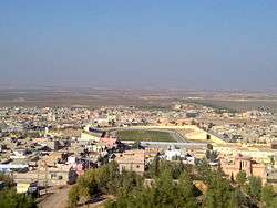
View of town from Bardarash | |
 Bardarash | |
| Coordinates: 36°30′12.2″N 43°35′14.0″E / 36.503389°N 43.587222°E | |
| Country |
|
| Province | Nineveh Governorate |
Bardarash (Barda Rash; Kurdish: Berdereş) is a township (district) located in Nineveh Governorate, 70 km north of Irbil, the capital of Iraqi Kurdistan Region, and 32 km north east of Mosul. All its people are Kurds and Sunni Muslims and the majority of them speak in Gorani accent (not language), Goran is also the name of the tribe that comprises the majority of the people in Bardarash district. That is why the accent they are speaking is called Gorani as well.
History
At the era of Ottoman Empire, Bardarash was recognized as a district (Nahiya) in 1879. At the time of Ottoman Empire and until the 1970s, it was known as ‘Ashair Al Sab’aa, the meaning of which is "Seven Tribes" in English, because it is said that there are seven major tribes which lived and still live in Bardarash; they are - Rashgary 55%, Gezh 23%, Bot 11%, Shekh-Bzeni 2%, Khidiry 1%, Zangana 1% and others 7%. All of them are called Gorani. But also other tribes live in this area and some of them migrated in the four last decades of 20th century, such as Surchi, Zebar, Sharafan etc.[1]
Bardarash was formerly joined to Akre, and they were joined to Ninewa province until the Uprising of 1991, after which both towns were liberated from the Ba’ath regime and they were joined to Duhok province until now. In 2008 the KRG decided to create a new district (Qaza) centred on Bardarash.

Etymology
Bardarash means "black stone"; this is because its soil in general is black or, there is a destination south of the Bardarash is called (Shaxe-Rash, Black-Rocks) and it’s said that people are used to live there before they transfer to current place.
Geography and population
Bardarash district is located between two rivers which they are (Upper- Zab, Zey Badinan) and (Xazir) in the east the west, and in north has a border with Akre and south with Mosul and Hawler. According to an (UN-WFP) census in 1997 the population of Bardarash district was 51,713 people.[1] But now according to Bardarash Mayoralty, Bardarash now consists of three subjoined districts, which are Daratoo, Roviya, and Kalak, and 88 villages. The population of Bardarash now is more than 115,000 people. Sub-districts joined to Bardarash are 1- Daratoo 2- Rovia 3- Kalak [2]

Economy
The area of Bardarash district according to some sources is 983 Square Kilometres. In general Bardarash is an agricultural area and until now most of the people depend on crop yields like wheat and barely. They used to have more sheep and cows than nowadays.
Bardarash is a rich area for oil resources and several foreign companies are now working on searching and producing oil. One of the companies has recently said that Bardarash is the second Kirkuk of Kurdistan for oil.
Social components
In Bardarash district the Goran tribe is dominant and they are subdivided into several smaller tribes. Tribal mentality has its biggest effect on the people of Bardarash and as a result of this mentality, there are some problems. As mentioned before there are several other tribes live in Bardarash, most of them came in 1975 when they migrated because of the Ba’ath toppled regime from Zumar, Atrush, Shexan, Rabee’a and Mreba and they were forced to settle in (Kanilan) village. After that Bardarash people took them and they divided to villages and many of them still live in Bardarash.[1]
Becoming a district
The ceremonies of turning Bardarash sub district into a district were performed in presence of Tamar Remezan, Duhok governor, the head of KDP branch (9), and a number of administrative and party officials and the dignitaries of the area. The mayor of Bardarash first gave a brief history of the sub district and the importance that KRG attached to the area after 1991, and he made it clear how important the decision to make Bardarash a district is. In his speech, the governor congratulated the people of the area and said that it is for the good of people that this decision was taken in order to give more attention to the area and promised to help improve the work of the administrative departments there. Mazin M. Saeed, the mayor, promised to do his best to provide services to the people. It is worth mentioning that Bardarash became a sub district in 1890 and more than 75000 people live in. It has two sub district (Kalak and Rovia), and another subdistrict is expected (Darato).[3]
Bardarash Uprising
On 12 March 1991 at 9 o’clock in the morning, Bardarash people like other Kurdish people in other parts of Kurdistan, started the uprising against Ba’ath regime and became the Gate of Uprising in Badinan, after that Akre and Duhok and Zaxo upraised against the regime and liberated. As we said before 1991 Bardarash and Akre were joined to Mosul province but after the uprising, Bardarash and Akre were only two towns that upraised against Ba’ath Regime in Ninewa province and after that they joined to Duhok province and still managed by the KRG.
Bardarash and The Battle of Gaugamela
During a workshop conducted by Salahadin University hosting an archeologist and a historian from the Greek Cyprus University, instructors and students of archeology department discussed for several hours the circumstances surrounding the battle. This resulted in pinpointing exactly where Gaugamela took place.
Muhamad Abdullah Kakasoor, Dean of the College of Arts at University of Salahadin stated that the battle was previously thought to have occurred near the city of Erbil. A team from the Greek Cyprus University visited Erbil recently to discover the real location of the battle. After a more thorough local investigation, they came to the conclusion that the battlefield was situated in the triangle of Maqloob Mountain ? Tel Gomer Village and Bardarash. Mr. Kakasoor said, after the delegation?s visit to the site, intensive excavations will be carried out. ?The importance of this topic is that Gaugamela or sometimes called Erbela is an international historical occurrence, whoever reads the history of Alexander will come across the name Erbela which undoubtedly refers to the current city of Erbil (or Hawler). He said that the Greek archeologists revealed that the real location of the battle is in Bardarash District rather than the place mentioned in Greek and Iranian historical sources. ?The Greek delegation has reached a conclusion, depending on their study and ancient and contemporary Greek sources that the battle occurred in Bardarash District which is a wide area suitable to be used as a battlefield. So now the actual location of the battle is settled? he argued. The battle is believed to be the first after which the West could dominate the East powers. According to the historical sources, Darius's army consisted of 100-200 thousand soldiers, but the technique Alexander used in the battle enabled him to win with fewer numbers of soldiers. The Head of Archeology at Salahadin University stated during the workshop that he visited the site in Bardarash himself. And according to the scripts and documents that Greek Cyprus University professors revealed, the site of the battle is located 90 km far away from the city of Erbil. In addition, they say that Persian sources mention the mountain that?s now known as Maqloob which both armies passed by ahead of their arrival to Gomel River, Upper Zap and Xazir River, and both armies reached Tel Gomel (a village in Bardarash District) where there?s a wide plain of 10 km long and 5–7 km wide. He added that the area is very wide, so excavating and searching for military equipment of both armies can be challenging. However, modern detecting equipments can facilitate searching and finding some pieces of weapons such as spears, bows and arrows or whatever made of iron and used in the fight. He also stated that excavations haven?t started yet. According to archeologists who took part in the workshop, the outcome of this workshop will be presented to Salahadin University and KRG Council of Ministers so that the location could be surveyed and excavated thoroughly and extensively, and finally turned into a very interesting archeological site in Kurdistan Region.[4]
References
- 1 2 3 Yaseen Hasan Goran, Xazir Magazine, Issue 2 - 15
- ↑ Hangaw Organization For Cultural Development Archived August 5, 2012, at the Wayback Machine.
- ↑ Bardarash becomes a district, from(Duhok governorate official website).
- ↑ The Location of the Battle of Gaugamela Discovered Archived April 13, 2014, at the Wayback Machine.