Bara Bandai
Bara Bandai (Pashto: بره بانډۍ )
| Bara Bandai | |
|---|---|
| Union Council & village | |
| Bara Bandai | |
| Country |
|
| Province | Khyber Pakhtunkhwa |
| District | Swat |
| Government | |
| • District Councler & Tehsil councler | Falak Naz & Riaz Ahmed |
| Area | |
| • Total | 6 km2 (2 sq mi) |
| Population (2012) | |
| • Total | about 12,000 |
| Time zone | PST (UTC+5) |
| Website | www.facebook.com/Bara Bandai |
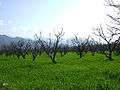
It is known for its natural beauty and lying in an area crossed by Alexander The Great during his invasion. The people of village Bara Bandai belong to subsection Naikpikhel of Yusufzai the biggest and largest tribe of Pashtun or Pakhtun tribes. It is one of the Provincially Administered Tribal Areas (PATA) of Pakistan. The village contains a small series of mountains and a jungle, residential area starting from meadows of mountains to the fields, a village market, vast land for crops, number of springs and canals, and a part of the Swat river. Famous mountains of village are Usmani Sar, Kafar Ghat and Najia Top.
Etymology
The village was named by Yusufzai Pakhtuns after they defeated and expelled the Swati tribe from Swat Valley. The name Bara means "Upper" and Bandai means "Meadow", hence was named Bara Bandai due to its locality. On the West side of Bara Bandai is the neighbouring village Kuza Bandai which means The Lower Meadow. The names were basically given by their greenery, comparing the distances of both villages from Mingora the main city of Swat Valley, and by comparing their distances from the upper mountainous areas of Swat such as Kalam and Bahrain. The ancient names of these villages are not known as they are just mentioned by locations in old times books and scripts.
Location
Bara Bandai is about 8 Kilometers away from Mingawara or Mingoara, the main city of Swat Valley and 10 Kilometers from Saidu Sharif the Capital of the Yousufzai State of Swat (Princely State). Situated on the left bank (North side) of Suvastu or The River Swat and is important and one of the large village of Nikpikhel. Nikpikhel is a sub tribe of Yousufzai and their area stretches in North to Godamanai bordering direcly with Dir district, Ningolai is on the East, Dadahara and Shamozai on the West. On the South side of Nikpikhel is The River Swat ([Suvastu]). Bara Bandai is about 80 Kilometers from Kalam, the famous tourist spot of North Pakistan. Bara Bandai comes under the PK-83 constituency of Khyber Pakhtunkhwa Provincial Assembly and NA-29 constituency of National Assembly of Pakistan.
POSTAL CODE
19201
Division
The village residential areas are divided into many sub units called as Chams (Pashto: چم) or Mohallah. Some of the major sub units are.
- Morragai (Miangano Cham)
- Hafiz Baba ( Khwajgan)
- Kotkay
- Sarkhana
- Awdal Khel
- Nasar Khel
- Bazar
- Chapolo (related to chapolo masjid which names after the tribe lived there called as "chapolo miagan")
- Saidu Bibi (named after the aunt of Wali Swat lived there. She was from Saidu Sharif and belongs to Wali Swat family).
- Matra.
- Zarpour Cham
- Sarhad Colony.
- Warsaky.
Photos
-
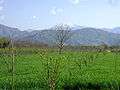
Peach Trees, Bara Bandai
-
Peach Trees, Bara Bandai
-

Greenery, Bara Bandai
Population
Total population of village Bara Bandai is 34626 (projected population 2009), 18006 males and 16220 females having registered voters above 5 thousands, which makes it one of the largest villages in the Swat valley. There are number of sub-tribes (clans) of Yusufzais living in the village. Some names of the tribes are Awdal Khel, Nasar Khel, khwajgan, Shado Khel, Adam khel, Saidu khel, Bucha Khel, Ajo Khel, Mandan, Bara Khan Khel, etc.
Education
The village consist of 1 high, 3 govt boys primary schools and 1 middle govt school for girls along with a number of schools in private sector.
Health
Bara Bandai has his own Basic Health Unit (BHU), many clinical laboratories and number of clinics in private sector which provide health facilities to the village people.
Climate
The weather of the village is very beautiful, very cold in the winter season and moderate during summer. Village have four seasons per year. Snowfall also occur here in winter which intensify its beauty.
Crops & Fruits
The village climate made it favorable for many crops and fruits. The village not only fulfill their own need but also supply its product to other areas . Among these onion & peach are major ones.