Bar'am
| Bar'am | |
|---|---|
 Bar'am | |
| Coordinates: 33°03′30″N 35°26′00″E / 33.05833°N 35.43333°ECoordinates: 33°03′30″N 35°26′00″E / 33.05833°N 35.43333°E | |
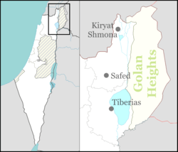
| District | Northern |
| Council | Upper Galilee |
| Affiliation | Kibbutz Movement |
| Founded | 16 June 1949 |
| Founded by | Demobilized Palmach soldiers |
| Population (2015)[1] | 590 |
| Website | www.baram.org.il |
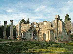

Bar'am (Hebrew: בַּרְעָם, lit. Son of the People) is a kibbutz in northern Israel. Located approximately 300 meters from Israel's border with Lebanon near the ruins of the ancient Jewish village of Kfar Bar'am.[2] Bar'am National Park is known for the remains of one of Israel's oldest synagogues.[3] The kibbutz falls under the jurisdiction of Upper Galilee Regional Council and had a population of 590 in 2015.
History
The site of Bar'am has been inhabited since ancient times; at an unknown point subsequent to the Arab conquest of the seventh century but before the thirteenth century, the Jewish population had left Kfar Bar'am, which became a mixed village made up of Christians and Muslims called Kafr Bir'im on the Lebanese border when the inhabitants were expelled by Israel Defense Forces in November 1948.[4] In 1949, with cross-border infiltration a frequent occurrence, the government of the new State of Israel decided not to allow Arab villagers to return to the border zone, which included Bir'im, for security reasons.[5]
Modern Bar'am was founded on 14 June 1949 to guard and hold the border with Lebanon by demobilized Palmach soldiers. The Muslim population was forcefully evicted and, despite a legal ruling in favour of the local Christian population, the village was bombed and destroyed by the Israeli Air Force. The kibbutz was established as a secular settlement of the Hashomer Hatzair movement.
Economy
Bar'am has orchards where apples, pears, nectarines, plums, and kiwi are grown, and a packing plant, where the fruit is sorted, packed and kept in cold storage until it is delivered to markets throughout Israel.[6] Other crops include corn, peanuts and sunflower seeds. In addition, the kibbutz has ponds for fish farming. The kibbutz also has land holdings cultivated with cotton in the Hula Valley, near Ne'ot Mordehai.
The kibbutz also has a factory that manufactures plastics for medical purposes.[7]
Culture
The kibbutz operates the Bar David Museum, which houses bi-annual exhibitions from the large permanent collection of paintings and Jewish ritual objects, plus temporary exhibitions of fine art, sculpture and photography, and a small Archeology Room that exhibits objects from the region, such as ceramic and glass artefacts and jewellery and statuettes.[8]
See also
References
- ↑ "List of localities, in Alphabetical order" (PDF). Israel Central Bureau of Statistics. Retrieved 16 October 2016.
- ↑ Jacob Neusner, Bertold Spuler & Hady R Idris (2001) Judaism in late antiquity, BRILL, p155
- ↑ Steven Fine (2005) Art and Judaism in the Greco-Roman world: toward a new Jewish archaeology, Cambridge University Press, pp13–14
- ↑ Benny Morris (2004) The Birth of the Palestinian Refugee Problem Revisited, ISBN 0-521-00967-7, pXXII
- ↑ Benny Morris (1997) Israel's border wars, 1949-1956: Arab infiltration, Israeli retaliation, and the countdown to the Suez War, 2nd Edition, Oxford University Press, p124
- ↑ Where volunteers are no anachronism, Jerusalem Post
- ↑ Where volunteers are no anachronism, Jerusalem Post
- ↑ Bar-David Museum of Jewish Art and Judaica Israel Museums
External links
- Official website (Hebrew)
- Kibbutzniks trade in socialism for stocks Atlanta Jewish Times, 4 November 2005
- Rockets fell on the new Tuscany The Economist, 17 August 2006
- the Fourth Annual Inuit-Israeli Tour Canada Awakening