Banten
| Banten | |||||||
|---|---|---|---|---|---|---|---|
| Province | |||||||
| Other transcription(s) | |||||||
| • Sundanese | ᮘᮔ᮪ᮒᮨᮔ᮪ | ||||||
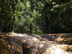
Clockwise, from top left : Soekarno-Hatta International Airport, Ujung Kulon National Park, Mount Karang, Carita Beach, Port of Merak | |||||||
| |||||||
|
Motto: Iman Taqwa (Faith and Piety) | |||||||
 Location of Banten in Indonesia | |||||||
| Coordinates: 6°30′S 106°15′E / 6.500°S 106.250°ECoordinates: 6°30′S 106°15′E / 6.500°S 106.250°E | |||||||
| Country |
| ||||||
| Capital |
| ||||||
| Government | |||||||
| • Governor | Rano Karno [1] | ||||||
| Area | |||||||
| • Total | 9,662.92 km2 (3,730.87 sq mi) | ||||||
| Population (2014) | |||||||
| • Total | 11,834,087 | ||||||
| • Density | 1,200/km2 (3,200/sq mi) | ||||||
| Demographics | |||||||
| • Ethnic groups | Bantenese (47%), Sundanese (23%), Javanese (12%), Betawi (10%), Chinese (5%)[2] | ||||||
| • Religion | Islam (91.64%), Christian (4.4%), Buddhism (1.2%), Confucianism (0.03%), Hindu (0.05%) | ||||||
| • Languages | Sundanese, Javanese, Indonesian, Hakka | ||||||
| Time zone | WIB (UTC+7) | ||||||
| Vehicle registration | A (Main), B (Partially) | ||||||
| HDI |
| ||||||
| HDI rank | 7th (2014) | ||||||
| Website | bantenprov.go.id | ||||||


Banten is the westernmost province on the island of Java, in Indonesia. The provincial capital city is Serang.
The population of Banten was officially estimated at 11,834,087 at the start of 2014, up from over 10.6 million during the 2010 census.[3] Formerly part of the province of West Java, Banten became a separate province in 2000. The province is a transit corridor to the neighbouring Indonesian island of Sumatra.
Historically, it has had a culture distinct from the rest of Java and that of the broader Indonesian archipelago. In recent years, the northern half, particularly those areas near Jakarta and the Java Sea coast, have experienced rapid rises in population and urbanization, while the southern half, particularly that facing the Indian Ocean, maintains more of its traditional character.
History
In the 5th century, Banten was part of the Kingdom of Tarumanagara. The Lebak relic inscriptions, found in lowland villages on the edge of Ci Danghiyang, Munjul, Pandeglang, Banten, were discovered in 1947 and contains 2 lines of poetry with Pallawa script and Sanskrit language. The inscriptions speak of the courage of king Purnawarman. After the collapse of the Tarumanagara kingdom, due to an attack by Srivijaya, power in the western Java fell to the Kingdom of Sunda. The Chinese source, Chu-fan-chi, written circa 1225, Chou Ju-kua mentioned that in the early 13th Century, Srivijaya still ruled Sumatra, the Malay peninsula, and western Java (Sunda). The source identifies the port of Sunda as strategic and thriving, pepper from Sunda being among the best in quality. The people worked in agriculture and their houses were built on wooden poles (rumah panggung). However, robbers and thieves plagued the country.[4] It was highly possible that the port of Sunda mentioned by Chou Ju-kua was probably refer to the port of Banten.
According to the Portuguese explorer, Tome Pires, in the early 16th century the port of Bantam (Banten) was an important port within the Kingdom of Sunda along with the ports of Pontang, Cheguide (Cigede), Tangaram (Tangerang), Calapa (Sunda Kelapa) and Chimanuk (estuarine of Cimanuk river).[5]
Sultanate of Banten
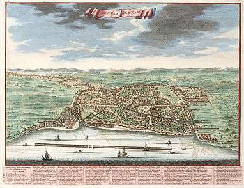
In 1527, just as the Portuguese fleet was arriving off the coast, newly converted Javanese Muslims under Sunan Gunungjati captured the port of Banten and the surrounding area from the Sundanese leaders and established the Sultanate of Banten. The center of this sultanate, according to J. de Barros, was Banten which was a major port in Southeast Asia rivaling Malacca and Makassar. The city of Banten was located in middle of the bay which is around three miles across. The city was 850 fathoms in length while the seaside town was 400 fathoms in length. Through the middle of town there was a clear river which ships and gale junks could sail into. There is a small tributary of the river extending to the edges of the town. Today, the river is not so large and only small boats can enter. There was a fortress very near to the town whose walls were made of brick and was seven palms wide. There were wooden defense buildings consisting of two levels and armed with good weapons. The middle of the town square was used for military activities and folk art, and as a market in the morning. The king's palace was located on the southern side of the square. Beside the building was an elevated and flat-roofed, called Srimanganti, which was used by the king when meeting the people. To the west of the square was a great mosque.
In the early 17th century, Banten was an important commercial center on international trade routes in Asia. At the time, the administration and governance of port were very supportive of economic growth. Its territory included the area which is now the province of Lampung in southern Sumatra.
When the Dutch arrived in Indonesia the Portuguese had long been in Banten. The English established a representative site in Banten, a "factory", and were followed by the Dutch. In addition, the French and Danes also came to trade in Banten. In the ensuring competition between the European traders, the Dutch emerged as the winners. The Portuguese fled Banten in (1601) after their fleet was destroyed by the Dutch fleet off the coast of Banten. While the coastal areas of Banten came under Dutch influence, the sultanate kept control over the inland region until 1813. In that year, the sultanate was abolished and transformed into a residency of the Dutch East Indies.[6]
Province of Banten
After Indonesia became independent, Banten was absorbed into the province of West Java. However, separatist sentiment ultimately led to the creation of the province of Banten in 2000.[6]
Geography
Banten lies between 5°7'50" and 7°1'11" south latitude and 105°1'11" and 106°7'12" east longitude.[7] The province has an area of 9,662.92 km².[8]
Banten is located near the Sunda Strait's strategic sea lanes that link Australia and New Zealand to Southeast Asia. Banten's ports accommodate the excess capacity of sea ports from Jakarta.
Topography
574,090 hectares or 65% of Banten is classified as flat, 186,320 hectares (21%) is classified as corrugated with slopes of between 2% and 15% steepness, while the remaining 118,471 hectares (13%) is classified as steep with slopes over 15%.
Administrative divisions
Banten Province is subdivided into four regencies (kabupaten) and four autonomous cities (kota), listed below with their populations at the 2000 and 2010 Censuses, together with the latest (2014) official estimates. The cities and regencies are additionally subdivided into 140 districts, 262 urban villages and 1,242 villages.
| Name | Capital | Area (km2) | Population Census 2000 | Population Census 2010 | Population 2014 Estimate[9] |
|---|---|---|---|---|---|
| Cilegon (city) | 175.51 | 294,936 | 374,559 | 416,901 | |
| Serang (city) | 266.71 | (a) | 577,785 | 643,101 | |
| Lebak Regency | Rangkasbitung | 3,426.56 | 1,030,040 | 1,204,095 | 1,340,213 |
| Pandeglang Regency | Pandeglang | 2,746.89 | 1,011,788 | 1,149,610 | 1,279,569 |
| Serang Regency | Ciruas | 1,734.28 | 1,652,763 | 1,402,818 | 1,561,401 |
| Western part Totals (outside Jabodetabek) | 8,349.95 | 3,989,527 | 4,708,867 | 5,241,185 | |
| South Tangerang (city) | 147.19 | (b) | 1,290,322 | 1,436,187 | |
| Tangerang (city) | 153.93 | 1,325,854 | 1,798,601 | 2,001,925 | |
| Tangerang Regency | Tigaraksa | 1,011.86 | 2,781,428 | 2,834,376 | 3,154,790 |
| Eastern part Totals (within Jabodetabek) | 1,312.98 | 4,107,282 | 5,923,299 | 6,592,902 | |
| Banten Totals | 9,662.93 | 8,096,809 | 10,632,166 | 11,834,087 | |
- (a) The 2000 Census population for Serang city is included in the figure for Serang Regency.
- (b) The 2000 Census population for South Tangerang city is included in the figure for Tangerang Regency.
Notes:
- Tangerang City was incorporated as an autonomous city on 27 February 1993 out of the Tangerang Regency, in which it previously served as administrative capital. It was subsequently replaced by Cipasera (see below).
- Cilegon City was incorporated as an autonomous city on 10 April 1999 out of the Serang Regency, in which it previously served as administrative capital. It was subsequently replaced by Serang (see below).
- Serang City was incorporated as an autonomous city in November 2007 out of the Serang Regency, in which it previously served as administrative capital. It was subsequently replaced by Ciruas.
- South Tangerang City (formerly Cipasera) was incorporated as an autonomous city on 29 October 2008 out of the Tangerang Regency. in which it previously served as administrative capital. It was subsequently replaced by Tigaraksa.
List of governors
At the time of the formation of Banten Province, Djamal Hakamudin was appointed as the first governor by the Indonesian central government. In 2002, the Banten provincial parliament (Dewan Perwakilan Rakyat Daerah or DPRD) chose Djoko Munandar and Ratu Atut Chosiyah as governor and deputy governor of Banten respectively. In early 2006, after Djoko Munandar was suspended during an investigation into alleged corruption, Ratu Atut Chosiyah was appointed as acting governor . Finally, on 6 December 2006, a provincial election was held which was won by Ratu Atut Choisiyah as governor and Mohammad Masduki as deputy governor; both served in the period 2007-2011.
| Name[10] | Position | Took office | Left office | Information |
|---|---|---|---|---|
| Hakamudin Djamal | Acting Governor | 2000 | 2002 | |
| Djoko Munandar | Governor | 2002 | 2005 | Removed on charges of corruption |
| Ratu Atut Chosiyah | Acting governor | 2005 | 2007 | |
| Ratu Atut Chosiyah | Governor | 2007 | 2012 | |
| Ratu Atut Chosiyah | Governor | 2012 | 2015 | Dismissed for bribery |
| Rano Karno | Acting Governor | 2014 | 2015 | |
| Rano Karno | Governor | 2015 | Incumbent | Starting on 12 August 2015 |
Transport
A major highway connecting Jakarta and Merak runs along the northern coast, divided into sections. It is composed of the Tangerang–Merak Toll Road and the Jakarta–Tangerang Toll Road, and forms part of the Trans-Java toll road.
Numerous train stations serve the province, operated by Indonesia's national rail operator, PT Kereta Api.
The province has the nation's busiest ferry terminals to Lampung on the island of Sumatra.
The only commercial airport in the province is the largest airport of the country, Soekarno–Hatta International Airport, which primarily serves the Greater Jakarta area, also known as Jabodetabek. The airport is located in the city of Tangerang. There are plans for introducing scheduled air services at Pondok Cabe Airport in South Tangerang.
References
- ↑ http://www.republika.co.id/berita/en/national-politics/15/08/12/nsyzxa317-rano-karno-officially-becomes-governor-of-banten
- ↑ Indonesia's Population: Ethnicity and Religion in a Changing Political Landscape. Institute of Southeast Asian Studies. 2003.
- ↑ "Archived copy". Archived from the original on 2013-07-27. Retrieved 2013-07-17.
- ↑ Soekmono, R. (1973). Pengantar Sejarah Kebudayaan Indonesia 2, 2nd ed. (5th reprint edition in 1988 ed.). Yogyakarta: Penerbit Kanisius. p. 60.
- ↑ Heuken, A. (1999). Sumber-sumber asli sejarah Jakarta, Jilid I: Dokumen-dokumen sejarah Jakarta sampai dengan akhir abad ke-16. Cipta Loka Caraka. p. 34.
- 1 2 Gorlinski, Virginia. "Banten". Encyclopædia Britannica.
- ↑ according to the Law of the Republic of Indonesia No. 23 year 2000
- ↑ Biro Pusat Statistik, Jakarta, 2014.
- ↑ Estimasi Penduduk Menurut Umur Tunggal Dan Jenis Kelamin Menurut Kabupaten/Kota Tahun 2014.
- ↑ Banten Governors. Statistics Banten Provincial Office, Banten. 2008.
External links
| Wikisource has the text of the 1911 Encyclopædia Britannica article Bantam. |
- Official website (Indonesian)
- Research and Development Agency (Indonesian)
Capital: Jakarta | ||
| Sumatra |  | |
| Java | ||
| Kalimantan | ||
| Lesser Sunda | ||
| Sulawesi | ||
| Maluku | ||
| Papua | ||
| Special Regions | ||
| Former Province | ||
Lists by
| ||