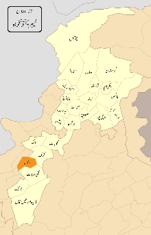
Bannu District
| District Bannu | |
|---|---|
| District | |
.svg.png) Khyber Pakhtunkhwa's location in the Pakistan | |
| Country | Pakistan |
| Province | Khyber Pakhtunkhwa |
| Headquarters | Bannu |
| Area | |
| • Total | 1,227 km2 (474 sq mi) |
| Population (2014) | |
| • Total | 1,073,000 |
| • Density | 552/km2 (1,430/sq mi) |
| Time zone | PST (UTC+5) |
Bannu District (Pashto: بنو, Urdu: ضلع بنوں, Avestan Varəna), as formed by the British in 1861,[1]: 3 is one of 26 districts that make up the Khyber Pakhtunkhwa province of Pakistan. It borders North Waziristan to the northwest, Karak to the northeast, Lakki Marwat to the southeast, and South Waziristan to the southwest. It is represented in the provincial assembly by four MPAs.[2] The district's main city is Bannu.[1]: 3–16
The major industries of Bannu are cloth weaving and the manufacturing of cotton fabrics, machinery, and equipment. It is famous for its weekly Jumma fair. The district forms a basin drained by the Kurram and Gambila (or Tochi) rivers, which originate in the hills of Waziristan. Although Bannu is surrounded by rugged and dry mountains, it is a very fertile place, and early English visitors had been known to refer to it as a "paradise" – see the beautiful description by Edwardes quoted by Thornton.[1]:6–7
Physical features
The district forms a basin drained by the Kurram River and Gambila River (or Tochi river)[3]:392 which originate in the hills of Waziristan. The Bannu Valley proper stretches to the foot of the frontier hills, forming an irregular oval, measuring 60 miles (100 km) from north to south and 40 miles (60 km) from east to west.[4]
The Kurram River, the larger of the two rivers, enters the district from the northwest, near the town of Bannu. From there, it runs first south-east, then south into Lakki Marwat. The Gambila River enters the district about 6 miles (9.7 km) south of the Kurram and flows in the same direction into Lakki Marwat, where the rivers eventually merge. Between these rivers and on the left bank of the Kurram in the upper portion of its course, lie the only tracts which are perennially irrigated. For the first 10 miles (16 km) of its passage through the district the Kurram runs between banks of stiff clay which rise abruptly to a height of 10 feet (3.0 m) to 30 feet (9.1 m), and its bed is full of stones and boulders; but downstream it spreads over long stretches of marshland. Its flow is rapid, but it is highly charged with a rich silt, which renders it valuable for irrigation[3] The famous and old village of Bannu is Sokari Karim Khan.
Location
Bannu District is approximately 192 km (119 mi) south of Peshawar and lies within a sedimentary basin. It is flanked on all sides by the hard and dried mountain ranges of Koh-e-Safed and Koh-e-Suleiman. The Kurram River and its tributaries make it a scenic part of the southern region, with meadows, crops and orchards. Every kind of crop and fruit can be grown here, but its banana, date, fig and rice crops are especially unique in taste, smell and shape.
The Bannu District is located in the heart of the southern region, bordering the districts of Karak in East-North and Lakki Marwat in East-South and the North and South Waziristan agencies.
History
The history of Bannu goes back to prehistoric times, due to its strategic location. Sheri Khan Tarakai is an ancient settlement site located in the Bannu District with ruins of the oldest known village settlement in the Bannu region, which was occupied from the late fifth until the early third millennium BC.[5]
The sacred texts of Zend Avesta and Vendidad mention that Varəna, the old name of Bannu, has one of the sixteen most beautiful and perfect lands created by Ahura Mazda, the God of Zoroastrianism, predating Islam.[6] Bannu is the homeland of FerΘraētaona/Frēdōn/Afrīḏūn;[7]:47–50 Bannu is noted by the Sanskrit grammarian Pāṇini as the "historical country of Varnu". It is also mentioned in the Mahāmāyūrī, and mentioned as Aornos in the 4th century passages of Alexander the Great.
In the 7th century AD the Chinese pilgrim, Xuanzang visited Bannu and Jaguda, while crossing the lands of O-po-kien (Afghans i.e. Pashtuns).
British era (1861–1947)
After the British annexation of Punjab, then including the North-West Frontier Province (NWFP), the valley was administered by Herbert Edwardes.[4] As a result of his administration, the region became a source of strong support, during the Indian Rebellion of 1857. Although the valley itself was peaceful, it was subject to incursions from the Waziri tribes of the Tochi Valley and the neighbouring hills. The primary export of the region was wheat. Salt and alum were also quarried at Kalabagh.[4]
The modern district of Bannu was originally a tehsil of the old Bannu district of British India, in the Derajat Division of the North-West Frontier Province. The capital Bannu in the north-western corner of the district was the British base for expeditions to the Tochi Valley and the Waziristan frontier. A military road led from Bannu town toward Dera Ismail Khan.
Upon the creation of the North-West Frontier Province in 1901, the district of Bannu (equivalent to the now defunct Bannu Division), contained an area of 1,680 sq mi (4,351 km2) lying north of the Indus; the cis-Indus portions of Bannu were ceded to the Mianwali District of the Punjab.
In 1901, the District's population was 231,485, of whom the majority was Muslim. The main frontier tribes on the border were the Wazir, comparatively recent immigrants from the hills, who are for the most part peaceable and good cultivators. Bettani, Banizi, a Pashtun people who have always been very independent and stubbornly resisted the Sikh predecessors of the British and Dawar.
As of 1911, the Indus had no bridges within the district, but was navigable for local boats throughout its course of 76 mi (122 km).[4]
In 1947, during the partition of India a majority of the Lehnda speaking urban dwellers of Bannu town and district left for India, as they were mostly Hindu and Sikh. The restriction of immigration of the refugees coming form the other side by the NWFP government at the time prompted the hill pashtuns who drive them out, to occupy the evacuated properties. The remaining minority urban Seraiki or Lehnda speaking Muslim inhabitants stayed behind.
After independence (1947–present)
In 1990, Prime Minister Nawaz Sharif announced that Bannu will be upgraded as a Divisional Headquarters. The Bannu District was divided in two, with the Lakki Marwat District separating and becoming its own district.
Administrative subdivisions
Bannu District is divided into thirty-six tehsils and union councils. They include:[8]
- Amandi Umar Khan
- Azim Killa
- Baka Khel
- Baloch
- Bharat
- Chagarmash Kheli Mu
- Shaamshi Khel
- Shahbaz Azmat Khel 1
- Shahbaz Azmat Khel 2
Demographics
The main tribes are the Bannuchi, Wazir, Bettani, Mehsud, Dawar, Marwat, Khattak and some Bangash and Sulaimankhel,[9] who speak local Pashto dialect Bannuchi and saraiki dialect of westren Punjabi. The district has a population of 677,346 spread over an area of 1,227 square kilometres (474 sq mi).
See also
References
- 1 2 3 S.S. Thorbourne (1883). Bannu; or our Afghan Frontier. London: Trűbner & Co. ISBN 1314135279.
- ↑ Constituencies and MPAs – Website of the Provincial Assembly of the NWFP
- 1 2 "Imperial Bannu District". Gazetteer of India. 6. Clarendon Press. 1908.
- 1 2 3 4
 One or more of the preceding sentences incorporates text from a publication now in the public domain: Chisholm, Hugh, ed. (1911). "Bannu". Encyclopædia Britannica. 3 (11th ed.). Cambridge University Press. p. 355.
 - ↑ Petrie, C.A., Thomas, K.D. & Morris, J.C. 2010. Chronology of Sheri Khan Tarakai, in Petrie, C.A. (ed.). Sheri Khan Tarakai and early village life in the borderlands of north-west Pakistan, Bannu Archaeological Project Monographs – Volume 1, Oxbow Books, Oxford: 343–352.
- ↑ Michael Witzel, "The Home of the Aryans" people.fas.harvard.edu.
- ↑ Gherardo Gnoli. Zoroaster’s Time and Homeland: a study on the origins of Mazdeism.Published by Istituto Universitario Orientale (1980), ASIN: B0018NEFO0.
- ↑ Provincial Disaster Management Authority, Government of Khyber Pakhtunkhwa (1 July 2009). "Pakistan: North West Frontier Province District, Tehsil and Union Code Reference Map" (PDF). United Nations Pakistan unportal.un.org.pk. Archived from the original (PDF) on 10 August 2013.
- ↑ "Tribes and Castes in Bannu Excerpts from Gazetteer of the Bannu District, 1887". Kyber Gateway. Khyber Watch, Pakhtun Forums. n.d. Retrieved 9 May 2016.
Coordinates: 33°03′38″N 70°33′08″E / 33.06048°N 70.552176°E
External links
- "History and Settlement of Bannu, Excerpts from Gazetteer of the Bannu District, 1887", Khyber.org
- Website about Bannu
