Bankura
| Bankura বাঁকুড়া | |
|---|---|
| City | |
|
Ekteshwar Shiva Temple | |
 Bankura Location in West Bengal, India | |
| Coordinates: 23°15′N 87°04′E / 23.25°N 87.07°ECoordinates: 23°15′N 87°04′E / 23.25°N 87.07°E | |
| Country |
|
| State | West Bengal |
| District | Bankura |
| Area | |
| • Total | 6,882 km2 (2,657 sq mi) |
| Elevation | 78 m (256 ft) |
| Population (2011) | |
| • Total | 3,596,292 |
| • Density | 523/km2 (1,350/sq mi) |
| Languages | |
| • Official | Bengali, English |
| Time zone | IST (UTC+5:30) |
| PIN | 722101, 722102 |
| Telephone code | 03242 |
| Lok Sabha constituency | Bankura |
| Vidhan Sabha constituency | Bankura |
| Website |
www |

Bankura (pron: bænˈkʊərə) is a city and a municipality in Bankura Sadar subdivision of Bankura district in the state of West Bengal, India. It is the headquarters of Bankura district.
Etymology
In the Mahabharata, Bankura was described as Suhmobhumi. The word Larh or Rarh (in Nagari: rāḍh) was introduced after 6th century A.D. It comes from the old Austric word ráŕhá or ráŕho which means “land of red soil”.[1] In ancient times "China called Ráŕh by the name of 'Láti'".[1] In Santali, lar means thread, rarh means tune and larh means snake. Perhaps the Jain and Greek scholars used this original Austric word Larh to indicate this dry forest region which was very difficult. The popularity of Manasa Puja, the worship of Snake-Goddess Manasa, shows this opinion might have some relevance. According to Nilkantha, a famous commentator of the Mahabharata, the words suhmo[bhumi] (Sanskrit: suhma-bhūmi) and Rarh are synonymous.
Scholars differs in their opinion about the etymology of the name Bankura. In the words of the Kol-Mundas, orah or rah means habitation. Many places of Rarh have an added rah at the end of their names. One of the most influential gods of the district Dharmathakur is called Bankura Roy. The name of the district may come from his name. Linguist Suniti Kumar Chatterjee thinks that the name came from the word banka (zig-zag), and its word-corruption banku, which means extremely beautiful, and he who must be worshiped. In 1979, the word “Bancoorah” was found in the map of Renal. In 1863, Gastrel referred this region as Bancoonda.
Geography
Bankura district is located in the western part of the state of West Bengal. It is a part of Bardhaman Division of the State and is included in the area known as "Rarh" in Bengal. Bankura district is situated at 23°15′N 87°04′E / 23.25°N 87.07°E. The Damodar River flows along the Northern boundary of the district. Bankura district is bounded by Bardhaman district in the north, Purulia district in the west and Paschim Medinapure district in the south.
The seasons in Bankura are generally distributed as hot summer (April–May), monsoon (June–September) and 'Cold season' (November–February). The humidity is usually medium to high throughout the year and the rainfall, though not heavy, is usually well distributed. The average annual rainfall received by the district is around 1,300 mm. The rainy months are generally July and August. 21.5% of the total geographical area of the district is made up of forest land, covering a total of 148,177 hectares. Net cultivable area of the district is 4.30 lakh hectares.
Demographics
In the 2011 census, Bankura municipality had a population of 3,596,292 out of which 1,840,504 were males and 1,755,788 were females, constituting 954 females per 1000 male as sex ratio. There was change of 12.64% in the population compared to population as per 2001. Effective literacy rate as in Census 2011 is 70.95%.[2]
As of 2011 India census,[2] Bankura town has a population of 3,596,292. Males constitute 1,840,504 of the population and females 1,755,788. Bankura has an average literacy rate of 70.95%, with 81.00% of the males and 60.44% of females literate. Total Child population in Bankura area is 405,401 out of which 208,632 are boys and 196,769 are girls, under the age of 6 years.
Police stations
Bankura police station has jurisdiction over Bankura municipality, Bankura I and Bankura II CD Blocks. The area covered is 439 km2. There are 3 town outposts and an outpost at Rajagram.[3][4]
Bankura Sadar Division woman police station, started in 2014, has jurisdiction over whole of Bankura Sadar subdivision.[5]
Transportation
Bankura Railway Junction is managed by the South Eastern Railways and is on the Adra-Midnapore rail route. It is in Bankura city. Bhubaneswar Rajdhani Express, Rupashi Bangla Express, Aranyak Express, Puri-New Delhi(Nandan Kanan) Superfast Express, Ernakulam-Patna Express, Howrah-LTT Samarsata Express and Purulia-Howrah Express pass through this station. It is the originating and terminating station of Bankura Damodar Railway[6] which will connect to Howrah-Bardhaman Chord section. Computerized reservation facility is available. Going towards north-west, Adra Junction Railway Station is the nearest main station and moving to south, Midnapore Railway Station is the major station next to Bankura.[7]
The Bankura Railway Station and bridge over Dhaleshwari River were built by Gujarati Railway Contractors of the town Jeewan Gangji Savaria and Lalji Raja Vadher in 1900 working for Bengal Nagpur Railway.
National Highway 14 (India) running from Morgam (in Murshidabad district) to Kharagpur (in Paschim Medinipur district), State Highway 9 (West Bengal) running from Durgapur (in Bardhaman district) to Nayagram (in Paschim Medinipur) and State Highway 5 (West Bengal) running from Rupnarayanpur (in Bardhaman district) to Junput (in Purba Medinipur) pass through Bankura. NH 14 links Bankura to NH 12 and NH 16. Both NH 14 and SH 9 link Bankura to NH 19 (Grand Trunk Road).[8][9]
Tourism
Bankura has gained much popularity among the tourists hailing from India. The place has a rich cultural and traditional heritage. It is famous for its paintings, music and other arts. It has gained popularity among domestic tourists due to the beautiful locations and historical destinations. The place has contributed great deal toward modern Bengal art and architecture. You can see the beautiful terracotta art and architecture in Bankura.[10] The tourist spots can be divided into four zones.[11]
Eastern Zone

- Bishnupur is an important tourist spot of Bankura district. It is 152 km from Kolkata and 34 km from Bankura Town. This place has a historical importance as it was the capital of Mallabhum. It is very famous for terracotta temples and Baluchari sarees. It is popular for classical music dalmadal and painting. There are approximately 16 temples, most of which are made in the decade of Mallaraja. Important temples of Bishnupur are Jor Mandir, Rasmancha, Radhamadhab Temple, Kalachand Temple, Madan Mohan Temple, Radha-Gobinda Temple and Shyam Ray Temple.
- Joyrambati is 98 km from Kolkata.[12] It is a holy place as it was the birthplace of Sree Sree Maa Sarada Devi. Temple of Singha Bahani Devi and Mayerepukur are also visiting sites.
Western Zone
- Susunia Hill is a very important tourist spot of Bankura District. It is 50 km[13] from Bisnupur and 21 km[14] from Bankura town. It is famous for natural spring and Silalipi.
- Biharinath Hill is the tallest (448 m)[11] of Bankura District. It is in the northwestern edge of the district. It is 57 km from Bankura Town. It was an ancient centre of Jainism. This place is famous for its natural beauty.[13] Biharinath offers hills, dense forest, water bodies, river Damodar, renowned temple of Lord Shiva, green unpolluted nature with salubrious atmosphere. Now Biharinath can boast of its advancement in tourism with accommodations having A.C. rooms and other modern amenities.
South Zone
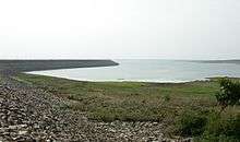
- Mukutmonipur is an important tourist spot of Bankura District. It is 55 km[13] from Bankura District headquarters. It is the second biggest earthen dam of India.[11] This place is very famous for its natural beauty and bluish tract of water.
- Jhilimili is another tourist spot, 70 km from Bankura Town. Its beauty lies in its dense natural forest.
Northern Zone
- Durgapur Barrage
- Gandoa Dam
- Koro Pahar (Amar Kanan)
Education
University
- Bankura University is the only university in the city.
Colleges
- Panchmura Mahavidyalaya
- Bankura Christian College
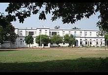
- Bankura Sammilani College
- Bankura Sammilani Medical College
- Bankura Unnayani Institute of Engineering
- Bankura Zilla Saradamani Mahila Mahavidyapith
- Barjora College, Barjora
- Saltora Netaji Centenary College, Saltora
- Sonamukhi College,Sonamukhi
Schools
- Bankura Zilla School
- Bankura Banga Vidyalay
- Bankura Hindu High School[15]
- Bankura Christian Collegiate School
- Rajgram Vivekananda Hindu Vidyalaya
- Madhuban Goenka Vidyalaya
- Kuchiakol R B institution[16]
Healthcare
- Bankura Sammilani Medical College and Hospital is the most important hospital of the district equipped with all major departments and diagonostic facilities.
- Bankura Sub-Divisional Hospital is an important hospital. It has a paediatric ward, blood test and OT.[17]
See also
References
- 1 2 P.R. Sarkar Rarh - The Cradle of Civilization, Ananda Marga Publications, 1981, Kolkata
- 1 2 http://www.bankura.nic.in/census.htm
- ↑ "District Statistical Handbook 2014 Bankura". Tables 2.1, 2.2. Department of Statistics and Programme Implementation, Government of West Bengal. Retrieved 14 October 2016.
- ↑ "Bankura PS". Bankura District Police. Retrieved 14 October 2016.
- ↑ "Bankura women PS Sadar subdivision". Bankura District Police. Retrieved 14 October 2016.
- ↑ http://www.banglalive.com/Feature/FeatureDetail/6895/[]
- ↑ ((www.india9.com))
- ↑ "Rationalisation of Numbering Systems of National Highways" (PDF). New Delhi: Department of Road Transport and Highways. Retrieved 3 April 2012.
- ↑ "List of State Highways in West Bengal". West Bengal Traffic Police. Retrieved 15 September 2016.
- ↑ http://www.maharashtraweb.com/WestBengal/cities/maps/bankuramap.asp
- 1 2 3 "Tourism, Bankura". Archived from the original on 25 September 2012. Retrieved 7 September 2012.
- ↑ "Kolkata to Jairambati". Retrieved 7 September 2012.
- 1 2 3 "West Bengal Tourism,Bankura". Archived from the original on 14 August 2012. Retrieved 7 September 2012.
- ↑ "Distance from Bankura to Susunia Hill". Retrieved 7 September 2012.
- ↑ https://www.facebook.com/pages/Bankura-Hindu-High-School/284047908362853?sk=info&tab=page_info
- ↑ https://m.facebook.com/groups/125676680862853?refid=46&sld=eyJzZWFyY2hfc2lkIjoiYTczNTlhZDNjYTE1NDU1YjYxZjlmZWFmYmUwY2ViZTkiLCJxdWVyeSI6Imt1Y2hpYWtvbCByIGIgaW5zdGl0dXRpb24iLCJzZWFyY2hfdHlwZSI6IlNlYXJjaCIsInNlcXVlbmNlX2lkIjoxODMxNjgwNzg0LCJwYWdlX251bWJlciI6MSwiZmlsdGVyX3R5cGUiOiJTZWFyY2giLCJlbnRfaWQiOjEyNTY3NjY4MDg2Mjg1MywicG9zaXRpb24iOjMsInJlc3VsdF90eXBlIjo2OX0%3D
- ↑ "Health Information of Bankura". Retrieved 8 September 2012.
External links
-
 Bankura travel guide from Wikivoyage
 - Bankura Official Website
- Bankura Christian College
- SOFIA: A social-welfare organization of Bankura
- National Informatics Centre website
- Bankura Unnayani Institute of Engineering website
- Upcoming website with pictorial database on plants growing in Bankura district
Cities, towns and locations in Bankura District | |||||||||||
|---|---|---|---|---|---|---|---|---|---|---|---|
| Cities, municipal and census towns |
| ||||||||||
| Locations other than cities and towns |
| ||||||||||
| Related topics |
| ||||||||||