Banffshire
| Banff | |
|---|---|
| County (until circa 1890) | |
 | |
| Country | Scotland |
| County town | Banff |
| Ranked {{{SizeRank}}} | |
| Chapman code | BAN |
Banffshire (/ˈbæmfʃər/; Scots: Coontie o Banffshire, Scottish Gaelic: Siorrachd Bhanbh) is a former county, and a Lieutenancy area of Scotland. The County of Banff is a Scottish registration county.[1]
Local government council
The county town was Banff although the largest community was Buckie to the west. It borders the Moray Firth to the north, Moray and Inverness-shire to the west, and Aberdeenshire to the south.
Until 1891 the county contained various exclaves which were locally situated in Aberdeenshire, the biggest being the parish and village of St. Fergus.[2]
Between 1890 and 1975 the County of Banff, also known as Banffshire, had its own county council.
In 1975 its Local Government council administration was superseded and divided between Moray council and Aberdeenshire councils.
From 1975 to 1996, its local government lay within the Grampian Region.
History
Considerable evidence of prehistoric human habitation exists particularly near the coastal area. For example, the Longman Hill cairn[3] and Cairn Lee are situated in the northern portion of Banffshire in the vicinity of the Burn of Myrehouse.[4]
Located in the area are the ruins of several medieval castles and the 12th century kirk of Gamrie.
The region remained largely Roman Catholic after the Reformation (16th century) and suffered greatly in the ensuing struggles.
During the Wars of the Three Kingdoms (17th century), Banffshire was a Royalist stronghold.
Cullen Church was known to have existed in 1236. The south aisle was added by Elena Hay in 1536 and dedicated to St Anne. It became a collegiate church in 1543 with six prebendaries and two singing boys to sing mass 'decently and in order every day'.
Cullen Church was the centre of the old kirkton of Cullen until 1820-30 when the township removed to the present 'new town' of Cullen and the manse, which had been close by, was rebuilt in Seafield Place in 1830.
Civil parishes

Civil parishes are still used for some statistical purposes, and separate census figures are published for them. As their areas have been largely unchanged since the 19th century this allows for comparison of population figures over an extended period of time.
From 1845 to 1930, parishes formed part of the local government system of Scotland, having parochial boards from 1845 to 1894.
- Aberlour
- Alvah
- Banff
- Bellie (probably now all in Moray)
- Boharm
- Botriphnie Drummuir
- Boyndie
- Cabrach
- Cullen
- Deskford
- Fordyce
- Forglen
- Gamrie
- Glass[5]
- Grange
- Inveraven or Inveravon
- Inverkeithny
- Keith
- Kirkmichael (possibly all in Banffshire)
- Marlach or Marnoch
- Mortlach (Mortlach distillery)
- Rathven
- Rothiemay Milltown of Rothiemay
- Rothnie
- Ontiquhill or Ordiquhill
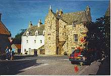
Principal mansions
Principal mansions in Banffshire c.1854 The Imperial gazetteer of Scotland (1854) VolI. by Rev. John Marius Wilson[6] lists the following :
- Auchintoul
- Auchlunkart House (A. Steuart)
- Balveny Castle or Balvenie Castle
- Cairfield House (John Gordon)
- Cullen House (Earl of Seafield)
- Duff House
- Edingight House (Major A.F. Innes Taylor)
- Forglen House and Birkenbog (Sir Robert Abercrombie)
- Gordon Castle (Duke of Richmond)
- Letterfourie (Sir William Gordon)
- Mayen House (William Duff)
- Mount-coffer House (Earl of Fife)
- Park House (Colonel Thomas Gordon)
- Rothiemay
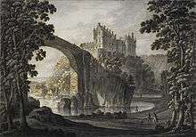
Castles in Banffshire
- Auchindune Auchindoun Castle
- Balveny or Balvenie
- Banff
- Cullen (near Cullen) [7]
- Deskford
- Edinglassie
- Findochty
- Galval or Gouldwell Castle (Boharm Civil Parish)
- Grange
- Inchdrewer, Banff Parish
- Scuth
Notable residents
- James Abercromby, (1706-1781), born in Glassaugh, British general in the French and Indian War.[8]
- Captain George Duff RN (c. 1 February 1764 – 21 October 1805) was a British naval officer during the American War of Independence, the French Revolutionary Wars and the Napoleonic Wars, who was killed by a cannonball at the Battle of Trafalgar. Born in Banff
- James Ferguson, FRS (1710-1776), born Rothiemay, astronomer and instrument maker.[9]
- George Gauld (surveyor)
- Saint John Ogilvie, (1579-1615), born in Keith was a Scottish Catholic martyr.
- George Stephen, 1st Baron Mount Stephen 1829-1921 Canadian railway executive who named Banff, Alberta after his birthplace; Banff National Park and Banff Springs Hotel are linked to Stephen back to Banffshire
Surnames
Most common surnames in Banffshire at the time of the United Kingdom Census of 1881:[10]
See also
- Lord Lieutenant of Banffshire
- Banffshire (UK Parliament constituency)
- List of counties of Scotland 1890–1975
References
- ↑ Registers of Scotland. Publications, leaflets, Land Register Counties.
- ↑ "St Fergus through time | Census tables with data for the Scottish Parish". Visionofbritain.org.uk. Retrieved 2012-11-12.
- ↑ "Longman Hill (Long Barrow) | UK". The Modern Antiquarian.com. 1924-12-24. Retrieved 2012-11-12.
- ↑ United Kingdom Ordnance Survey Map 1:50,000 (2004)
- ↑ The Imperial gazetteer of Scotland (1854) of Scotland (1854) by Rev. John Marius Wilson https://archive.org/stream/imperialgazettee01wils#page/791/mode/1up
- ↑ The Imperial gazetteer of Scotland (1854). Vol I. by Rev. John Marius Wilson p.130
- ↑ http://www.cullen-deskford-church.org.uk/deskford-castle.php
- ↑ Who Was Who in America, Historical Volume, 1607-1896. Chicago: Marquis Who's Who. 1963.
- ↑ "Library and Archive Catalog". The Royal Society. Retrieved 21 July 2010.
- ↑ Most Common Surnames in Banffshire
External links
| Wikimedia Commons has media related to Banffshire. |
 "Banffshire". Encyclopædia Britannica. 3 (11th ed.). 1911.
Coordinates: 57°30′N 3°05′W / 57.500°N 3.083°W