Bandundu (city)
| Bandundu | |
|---|---|
|
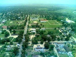
View of city center from the air, 2007 | |
 Bandundu Location in Democratic Republic of the Congo | |
| Coordinates: 3°19′S 17°22′E / 3.317°S 17.367°ECoordinates: 3°19′S 17°22′E / 3.317°S 17.367°E | |
| Country |
|
| Province | Mai-Ndombe Province |
| Area | |
| • Total | 222 km2 (86 sq mi) |
| Elevation | 321 m (1,053 ft) |
| Population (2012) | |
| • Total | 143,435 |
| • Density | 650/km2 (1,700/sq mi) |
| Climate | Aw |
Bandundu, formerly known as Banningville or Banningstad, is a city in the Mai-Ndombe Province of the Democratic Republic of the Congo.
Location
Bandundu is located on the east bank of the Kwango River, just north of the juncture of the Kwango and the Kwilu, and 8 kilometres (5.0 mi) south from the mouth of the Kwango on the Kasai River. It is around 260 kilometres (160 mi) from Kinshasa by air, or about 400 kilometres (250 mi) by road. In 2009, Bandundu had an estimated population of 133,080.[1]
Climate
Under the Köppen climate classification, Bandundu has a tropical wet and dry climate (Aw).[2]
| Climate data for Bandundu | |||||||||||||
|---|---|---|---|---|---|---|---|---|---|---|---|---|---|
| Month | Jan | Feb | Mar | Apr | May | Jun | Jul | Aug | Sep | Oct | Nov | Dec | Year |
| Record high °C (°F) | 37.0 (98.6) |
35.6 (96.1) |
36.5 (97.7) |
35.5 (95.9) |
35.3 (95.5) |
34.2 (93.6) |
33.3 (91.9) |
35.4 (95.7) |
35.2 (95.4) |
34.8 (94.6) |
34.4 (93.9) |
33.9 (93) |
37.0 (98.6) |
| Average high °C (°F) | 30.6 (87.1) |
31.1 (88) |
31.4 (88.5) |
31.4 (88.5) |
31.3 (88.3) |
30.6 (87.1) |
29.5 (85.1) |
30.7 (87.3) |
31.0 (87.8) |
31.0 (87.8) |
30.5 (86.9) |
30.3 (86.5) |
30.8 (87.4) |
| Daily mean °C (°F) | 26.2 (79.2) |
26.5 (79.7) |
26.6 (79.9) |
26.7 (80.1) |
26.7 (80.1) |
25.6 (78.1) |
24.5 (76.1) |
25.5 (77.9) |
26.1 (79) |
26.3 (79.3) |
26.0 (78.8) |
26.1 (79) |
26.1 (79) |
| Average low °C (°F) | 21.8 (71.2) |
21.9 (71.4) |
21.8 (71.2) |
22.0 (71.6) |
22.1 (71.8) |
20.6 (69.1) |
19.5 (67.1) |
20.3 (68.5) |
21.2 (70.2) |
21.6 (70.9) |
21.5 (70.7) |
21.9 (71.4) |
21.4 (70.5) |
| Record low °C (°F) | 17.9 (64.2) |
18.2 (64.8) |
18.6 (65.5) |
18.6 (65.5) |
17.0 (62.6) |
15.8 (60.4) |
15.0 (59) |
15.0 (59) |
18.6 (65.5) |
18.5 (65.3) |
18.7 (65.7) |
17.8 (64) |
15.0 (59) |
| Average precipitation mm (inches) | 144 (5.67) |
149 (5.87) |
169 (6.65) |
171 (6.73) |
100 (3.94) |
23 (0.91) |
6 (0.24) |
22 (0.87) |
107 (4.21) |
213 (8.39) |
246 (9.69) |
192 (7.56) |
1,542 (60.71) |
| Average precipitation days (≥ 0.1 mm) | 7 | 9 | 6 | 8 | 6 | 2 | 1 | 2 | 8 | 8 | 10 | 9 | 75 |
| Source: Deutscher Wetterdienst[3] | |||||||||||||
Economy
Bandundu was once a significant river port, as it is the largest town on the river between Kinshasa and Kikwit. However, traffic on the Kasai and Kwango Rivers dropped dramatically as a result of the Second Congo War, and has yet to recover. Bandundu does have intermittent passenger and freight service to Kinshasa, Mushie and Kikwit. Since 2008, there is a car/truck ferry service running several times per day across the Kwango. An unpaved road, roughly 250 km long, runs from this point to the main (paved) highway between Kinshasa and Kikwit.
Bandundu has a small regional airport, with direct flights to Kinshasa.
Unlike many cities in the Congo, Bandundu has a fairly constant supply of electricity. However this has nothing to do with Inga-Shaba HVDC line, as this line has no intermediate terminals.
As a provincial capital, Bandundu has had a MONUC presence since 2004.
Sister cities
Gallery
-

Seat of the Provincial Assembly
-

Road in the town center
-

Market
-
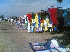
Clothing market
-

River Kwilu at Bandundu
-

Beside the River Kwilu
See also
References
- ↑ "Congo (Dem. Rep.): largest cities and towns and statistics of their population". World Gazetteer. Retrieved January 21, 2009.
- ↑ Peel, M. C.; Finlayson, B. L.; McMahon, T. A. (2007). "Updated world map of the Köppen–Geiger climate classification" (PDF). Hydrol. Earth Syst. Sci. 11: 1633–1644. doi:10.5194/hess-11-1633-2007. ISSN 1027-5606.
- ↑ "Klimatafel von Bandundu, Region Bandundu / Dem. Rep. Kongo (Zaire)" (PDF). Baseline climate means (1961-1990) from stations all over the world (in German). Deutscher Wetterdienst. Retrieved 1 April 2016.