Baltimore Metro Subway
| Metro Subway | |
|---|---|
|
| |
|
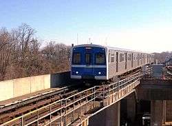
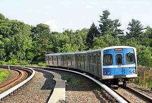
Metro Subway train entering the Reisterstown Plaza station, bound for Owings Mills | |
| Overview | |
| Type | Rapid transit |
| Status | Operational |
| Locale | Baltimore, Maryland |
| Termini |
Owings Mills (west) Johns Hopkins Hospital (east) |
| Stations | 14 |
| Daily ridership | 40,100 (Q2 2016)[1] |
| Ridership | 12,948,400 (2015)[2] |
| Operation | |
| Opened | November 21, 1983 |
| Owner | Maryland Transit Administration |
| Operator(s) | Maryland Transit Administration |
| Character | Underground, surface, elevated |
| Depot(s) | 5801 Wabash Avenue[3] |
| Rolling stock | 100 Budd cars[4] |
| Technical | |
| Line length | 15.4 mi (24.8 km)[5] |
| Track length | 34 mi (55 km)[3] |
| Number of tracks | 2 |
| Track gauge | 4 ft 8 1⁄2 in (1,435 mm) standard gauge |
| Electrification | Third rail (700 VDC)[5] |
| Operating speed | 70 mph (110 km/h)[4] |
| Highest elevation | 28 ft (8.5 m)[4] |
The Baltimore Metro Subway, known locally as the Metro Subway, The Subway, or the Baltimore Metro,[6] is a rapid transit line serving the greater area of Baltimore, Maryland, in the United States, and operated by the Maryland Transit Administration. Despite its name, less than half of the line is underground; most of the line outside of the central city is elevated or at surface grade.[4]
History
The origins of the Metro Subway lie in the Baltimore Area Mass Transportation Plan, published in 1965, which envisioned six rapid transit lines radiating out from a central city loop. Planning studies from 1968 proposed a rail transit system 71 mi (114 km) long.[4]
As the vision was translated into reality, the original concept was trimmed to a 28 mi (45 km) system in the Phase 1 plan, published in 1971. This plan involved two of the original six lines: a northwest line from Downtown Baltimore to Owings Mills and a south line to Glen Burnie and the airport. Phase 1 was approved for funding by the Maryland General Assembly in 1972. In response to crime concerns of Anne Arundel County residents, the MTA eliminated the south line from Phase 1 plans in 1975.[4]
When the Baltimore Metro opened on November 21, 1983, only the "Northwest" line of the 1965 plan had come to fruition. This 7.6 mi (12.2 km) segment provided service between Charles Center in Downtown Baltimore and Reisterstown Plaza in the northwest section of the city. In 1987, a 6.1 mi (9.8 km) addition extended the line from Reisterstown Road Plaza to Owings Mills in Baltimore County, much of it running in the median of I-795. A further extension of 1.6 mi (2.5 km) from Charles Center to Johns Hopkins Hospital was opened in 1994.[3][5]
Once the project was completed in 1995, the total cost for the Metro Subway was $1.392 billion.[4]
The current system is 15.4 mi (24.8 km) long, including 6.2 mi (10 km) underground, 2.2 mi (3.5 km) elevated, and 7.0 mi (11.3 km) at grade level (with roadways separated). Eight of its 14 stations are underground, at depths of 52 ft (16 m) to 112 ft (34 m) below street level. Its elevated stations stand from 25 ft (7.6 m) to 28 ft (8.5 m) above ground.[5]
Operation
Route
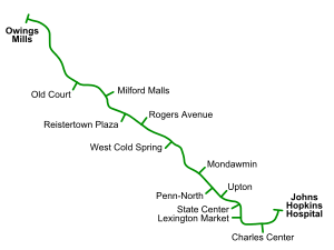
The Metro Subway's route consists of a single line in a shape that can be described as an extremely lopsided "U". Trains head south underground from Johns Hopkins Hospital, turn west as they pass under Baltimore's central business district, then north and ultimately northwest towards Owings Mills. The route leaves its tunnel northwest of Mondawmin station, entering an elevated structure that parallels Wabash Avenue and the Western Maryland Railroad. The route eventually leaves the older railroad right of way to enter the I-795 median, which it occupies all the way to the system's Owings Mills terminus.
Trains heading for Johns Hopkins Hospital are referred to as "eastbound" trains, while trains heading towards Owings Mills are said to be "westbound".[6]
Schedules
A trip from one end of the line to the other takes about half an hour. Headways range from 8 minutes during daytime peak to 11 minutes late at night and on weekends. Trains run from 5 a.m. to midnight on weekdays, 6 a.m. to midnight on weekends.[6]
Fares
These are the current fare prices for MTA buses, Light Rail, and Metro Subway travel.[7]
| Type | Regular fare | Reduced fare |
|---|---|---|
| Single trip | $1.70 | $.70 |
| Day Pass | $4.00 | $2.00 |
| Weekly Pass | $22.00 | - |
| Monthly Pass | $68.00 | $20.00 |
- Note: People who qualify for paratransit services can use Metro Subway free of charge.
Connecting services
Most Metro Subway stations are served by a number of MTA bus routes. In 1984, just months after Metro first started operating, many feeder routes were created that were given the designation of a letter (M, P, or R) followed by a number. In 1987, many of these routes were renamed and only the prefix "M" was used. Over the years, the number of M-lines has shrunk, as many of the routes were consolidated. In 2008, routes that were designated with the letter "M" have been renamed to plain two-digit designations. Finally, on August 30, 2009, the last four were either renumbered or eliminated, with no routing changes made; they continue to act as feeder routes to the Metro Subway.
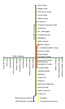
There is no direct connection to the Baltimore Light Rail or to MARC. The Metro Subway's Lexington Market Station is a 200-yard (180 m) walk from the Light Rail stop of the same name and the State Center Station is about 1.5 blocks away from Light Rail's Cultural Center. In addition, MARC Penn Station is about a one-half mile walk from State Center, and MARC Camden Station is about five blocks from Lexington Market.
Stations and connecting services
| Distance (mi) | Station | Location | Parking | Connections | Connections within close walk |
|---|---|---|---|---|---|
| 0.0 | Owings Mills | Painters Mill Road near I-795 underpass | 3500 | MTA buses: 56, 59 | |
| Old Court | Old Court Road near Greenwood Road | 625 | MTA buses: 18, 53, 77, 99 | ||
| Milford Mill | Roman Frasier Lane and Bedford Road (near Milford Mill Road) | 1300 | MTA buses: 54 | ||
| 6.1 | Reisterstown Plaza | Wabash Avenue and Patterson Avenue | 700 | MTA buses: 27, 58, 59, 60 | MTA buses: 53 |
| Rogers Avenue | Rogers Avenue at Wabash Avenue | 900 | MTA buses: 27, 33, 44, 51, 57, 91 | MTA buses: 53 | |
| West Coldspring | Wabash Avenue at Coldspring Lane | 300 | MTA buses: 33, 51, 97 | MTA buses: 53 | |
| Mondawmin | Liberty Heights Avenue at Reisterstown Road | 175 | MTA buses: 1, 5, 7, 16, 21, 22, 51, 52, 53, 54, 97 | ||
| Penn-North | Pennsylvania Avenue at North Avenue | none | MTA buses: 7, 13, 21, 54, 91 | MTA buses: 5 | |
| Upton/Avenue Market | Pennsylvania Avenue at Laurens Street | none | MTA buses: 7 | MTA buses: 5, 21 | |
| State Center/Cultural Center | Preston Street at Eutaw Street | none | MTA buses: 19, 21, 31, 91, 410 |
MTA buses: 27 Light Rail: Cultural Center | |
| Lexington Market | Eutaw Street at Saratoga Street (north entrance), Lexington Street (south entrance) | none | MTA buses: 1, 5, 15, 19, 23, 27, 47, 91 Light Rail: Lexington Market |
MTA buses: 7, 8, 10, 20, 23, 35, 36, 40, 47, 48, 105115119120, 150, 320 | |
| 13.8 | Charles Center | Baltimore Street at Charles Street (west entrance), Calvert Street (east entrance) | none | MTA buses: 1, 5, 8, 10, 20, 23, 26, 36, 40, 46, 48, 91, 105110115 164120, 150, 160, 310 |
MTA buses: 3, 11, 19, 35, 61, 64, 320, 410, 411 CCC: Purple |
| Shot Tower/Market Place | Baltimore Street at President Street | none | MTA buses: 23, 26, 40 |
MTA buses: 7, 10, 11, 420 CCC: Green, Orange | |
| 15.4 | Johns Hopkins Hospital | North Broadway and Monument Street | none | MTA buses: 5, 13, 15Express, 35, 46, 47, 104 104105110 CCC: Green |
MTA buses: 15, 21, 46, 47, 105115120, 160, 310, 320, 411, 420 |
Source:[8]
Performance
For fiscal year 2010, the MTA reported 95% on-time performance for the system. It averaged 3.0 passenger trips per revenue mile, with a total of 13.4 million passenger trips for the year. Vehicles operated at an average cost of $11.59 per revenue mile. Local buses, in comparison, performed at a cost of $13.57 per revenue mile.[9]
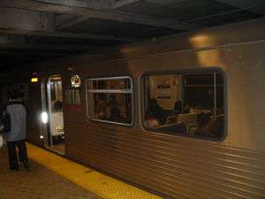
Rolling stock
These cars were manufactured by the Budd/TransitAmerica Red Lion plant in Northeast Philadelphia. Most were delivered in 1983 with a supplementary set of essentially identical cars being purchased in 1986 for the line expansion. The cars, marketed by Budd as the Universal Transit Vehicle, are identical to those used on the Miami Metrorail because the two agencies built their systems at the same time and saved money by sharing a single order.[4]
These cars were among the last railcars to be built by Budd before the firm shut down.
Trains draw power from the electric third rail. The cars are 75 feet (23 m) long, 10 feet (3.0 m) wide, and have a top speed of 70 mph (110 km/h). Cars are semi-permanently attached in married pairs, and 2-, 4- and 6-car trains are all seen on the line. Each car can hold up to 166 passengers (76 seated, 90 standing).[4]
The fleet had a significant overhaul between 2002 and 2005. Seats were reupholstered, and the floors were replaced. External destination rollsigns were replaced with LED displays; internal systems that display train destinations and upcoming stop announcements were also installed.
The MTA currently owns 100 Metro Subway cars;[9] approximately 54 are in use during peak weekday travel times.
Proposed extension
Consideration is being given for an extension, from the Metro Subway's Johns Hopkins Hospital terminus northeast to Morgan State University, dubbed the Green Line. Due to the expected high cost of building it as an extension of the existing Metro Subway (which would require tunneling in densely populated neighborhoods), the extension may take the form of a connecting light rail or bus rapid transit service. As of 2011, plans have not progressed.
See also
References
- ↑ "Transit Ridership Report Second Quarter 2016" (pdf). American Public Transportation Association. August 22, 2016. Retrieved 2016-11-14 – via http://www.apta.com/resources/statistics/Pages/ridershipreport.aspx.
- ↑ "Transit Ridership Report Fourth Quarter 2015" (pdf). American Public Transportation Association. March 2, 2016. Retrieved 2016-03-19 – via http://www.apta.com/resources/statistics/Pages/ridershipreport.aspx.
- 1 2 3 "MTA Media Guide 2010-2011" (PDF). MTA Maryland. August 2010. pp. 4, 9, 10. Retrieved June 30, 2011.
- 1 2 3 4 5 6 7 8 9 Scott M. Kozel (October 13, 2002). "Baltimore Metro Subway". Roads to the Future. Archived from the original on 8 August 2002. Retrieved June 28, 2002.
- 1 2 3 4 Robert Schwandl. "Baltimore Metro Subway". UrbanRail.Net. Retrieved November 27, 2014.
- 1 2 3 "Metro Subway". MTA Maryland. Retrieved June 30, 2011.
- ↑ "Regular Fares". Maryland Transit Administration. Retrieved 2016-09-06.
- ↑ "Metro Subway Schedule" (PDF). MTA Maryland. Retrieved June 30, 2011.
- 1 2 "2012 Annual Report" (PDF). MTA Maryland. p. 30. Retrieved October 10, 2013.
External links
| Wikimedia Commons has media related to Baltimore Metro. |
- Baltimore Metro Map. Maryland State Archives.
| Topics |   | |
|---|---|---|
| Attractions |
| |
| Education | ||
| Government | ||
| Industry | ||
| Parks | ||
| Sports | ||
| Transportation | ||