Ballylongford
| Ballylongford Béal Átha Longfoirt | |
|---|---|
| Village | |
|
Lislaughtin Abbey ruins and modern cemetery | |
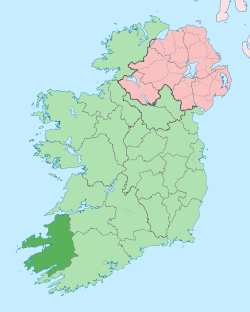
 Ballylongford Location in Ireland | |
| Coordinates: 52°32′46″N 9°28′41″W / 52.546°N 9.478°WCoordinates: 52°32′46″N 9°28′41″W / 52.546°N 9.478°W | |
| Country | Ireland |
| Province | Munster |
| County | County Kerry |
| Elevation | 4 m (13 ft) |
| Population (2006)[1] | |
| • Total | 406 |
| Irish Grid Reference | Q996449 |

Ballylongford (historically Bealalongford, from Irish: Béal Átha Longfoirt, meaning "ford-mouth of anchorage")[2] is a village near Listowel in north County Kerry, Ireland.
Geography
The village is situated at the top of a creek of Ballylongford Bay on the tidal estuary of the River Shannon, close to Carrigafoyle Island and on the coast road between Tarbert and the seaside town of Ballybunion.
The farmland is suited to dairying and this is a mainstay of the local economy along with fishing and tourism.
Three kilometers to the north, on Carrigafoyle Island, stands the castle and anchorage commemorated in the name of the village. For centuries, Ballylongford shared the political, military and religious fate of the castle and the nearby Franciscan Lislaughtin Abbey.
History
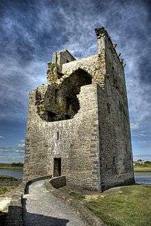
Carrigafoyle Castle was built between 1490 and 1500 by Conchuir Liath Uí Conchuir (Connor Liath O’Connor) using a design borrowed from the Normans. In addition to fine windows and archways, it features a spiral staircase of 104 steps that visitors can climb today. The castle, now a listed National Monument, stands almost 30 m high and its battlements provide stunning views of the estuary and the monastic Scattery Island in County Clare. The O'Connors of Kerry held political sway from this strategic base which allowed them to “inspect” ships passing to and from the port of Limerick. Thus, “taxation” and smuggling were the main sources of income. The castle was fortified and the narrow spiral staircase ascends clockwise thus disadvantaging any attacker, particularly right-handed ones.
In 1580, during the Second Desmond Rebellion, the castle was defended by a garrison composed of some 70 Irish, Italian and Spanish troops, led by Captain Julian, an Italian. The Siege of Carrigafoyle Castle by Elizabethan forces under Lord Justice Sir William Pelham began on Palm Sunday. After two days, it was breached by cannon fire and taken, following which the surviving defenders were all hanged. The cannon breach is clearly visible to this day. Towards the end of the Nine Years War, taking advantage of the distraction of the English, Chieftain John O'Connor briefly re-occupied the castle only to be put out again in 1603 by George Carew, the Governor of Munster.
King James I restored the castle to the O'Connors in 1607 but in 1651 during the Cromwellian conquest of Ireland, it was again captured, this time by Cromwellian forces under Edmund Ludlow. Ludlow was Henry Ireton’s second in command and, after Ireton's death, commander in chief in Ireland. Ludlow ensured that the castle could never again be fortified and garrisoned, by knocking the outer defensive walls.
The O’Connor lands were confiscated under the Act for the Settlement of Ireland of 1652 and given to William Sandes of Cumberland, who had arrived in Ireland with Oliver Cromwell in 1649. Following the restoration of the monarchy the lands were subsequently granted to Trinity College Dublin in 1666. The College remained the principal landlord in the Ballylongford area up to the passage of the Land Act in 1903. Indeed, some land titles are still vested in the college to this day.
.jpg)
On the other side of the creek, the O'Connors built the Friary of Lislaughtin in 1478, known locally as Lislaughtin Abbey (Lios Laichtin, meaning Lachtin's Dwelling). St Lachtin was the first to preach Christianity in the area. Two of the O'Connor chiefs are buried within its walls. The Abbey was raided twice by English forces coinciding with the military action against Carrigafoyle Castle, above. The Abbey was dissolved in the 17th century. A priceless processional cross, probably buried by the friars for safekeeping, survived the raids and was later discovered by a farmer. This processional cross, known as Lislaughtin Cross, is now on display in the National Museum in Dublin. Today, the Abbey and its grounds serve as the town's primary Roman Catholic cemetery.
The village in its present form dates from the end of the eighteenth century, though a bridge over the ford existed long before then. The old bridge was destroyed by flood in 1926. A reinforced concrete bridge was completed in 1930 and stands to this day. Photographs taken at the turn of the century show the village to have been largely made up of thatched houses, but many of these were burned by the Black and Tans during the War of Independence.
A concrete coastal artillery fort, Fort Shannon, rests six kilometers from the village. Constructed in 1940, it is the only such fortification built by the Irish Defence Forces during World War II, termed the Emergency in Ireland.[3]
Village development
In April 2006, Shannon Development entered into an option agreement with Shannon LNG Ltd, in relation to 281 acres (1.14 km2) of the Company’s 600-acre (2.4 km2) landbank at Tarbert-Ballylongford, Co Kerry. Shannon Development had designated this site for deep-water projects and has marketed the potential of the site to an international business audience. The site is about 25 km from the national gas pipeline grid.
Under the agreement, Shannon LNG Ltd, an Irish subsidiary of Hess LNG Limited, propose to build a €400 million liquefied natural gas (LNG) receiving terminal. Preparatory work is underway, including site investigations. Planning permission for the terminal was granted in 2008 by An Bord Pleanála. In November 2006, Shannon Development advertised for expressions of interest for further potential projects for the remaining 300 acres (1.2 km2) of its Tarbert-Ballylongford landbank.
People
- Brendan Kennelly, poet and novelist, was born in Ballylongford in 1936. There is a festival celebrating Kennelly's work each August featuring poetry, workshops, theatre, music, dance, literary and other events.
- Horatio, and later Lord, Kitchener was born in Ballylongford in 1850 and baptised in the parish church of Aghavallin (Achadh Chonbhail, meaning the field of the hermitage). Dating from the 14th century and originally Roman Catholic, the church came into the possession of the Church of Ireland at the time of the Reformation, and was used as the parish church until 1829, when a new church was built on the opposite side of the road.
- Father Malachi Martin, Roman Catholic priest, former Jesuit and author of sixty books
- Detective Garda Jerry McCabe, of the Garda Síochána, was killed in Adare, County Limerick on June 7, 1996, by members of the Provisional IRA during the attempted robbery of a post office.
- Michael O'Rahilly ("The O'Rahilly"), prominent in the Gaelic League, and one of the founders of the Irish Volunteers was born in the village in 1875. He was killed while retreating from the GPO in Dublin during the Easter Rising of 1916. A plaque marks the house and a life–size portrait, presented to the village by his family, is in Michael Finucane’s Public House, which was formerly the O’Rahilly family’s business premises. Ballylongford's local Gaelic football Club is known as "O'Rahilly's Gaelic football Club".
See also
References
- ↑ "Census 2006 – Volume 1 – Population Classified by Area" (PDF). Central Statistics Office Census 2006 Reports. Central Statistics Office Ireland. April 2007. Archived from the original (PDF) on 7 June 2011. Retrieved 2011-06-14.
- ↑ Placenames Database of Ireland (see archival records)
- ↑ Irish Military Archives – http://www.militaryarchives.ie/collections/offline-collections/coastal-defence-artillery-collection; retrieved 31 January 2013.
- Shepherd, S, et al. (1992) Illustrated guide to Ireland, Reader's Digest Association, London
- Various Authors (1970) Illustrated road book of Ireland, Second Edition, Automobile Association, London
- Ballylongford website
- New Network of Thematic Museums