Ball's Pyramid
| Ball's Pyramid | |
|---|---|
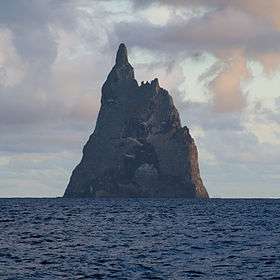 Ball's Pyramid from the north | |
| Highest point | |
| Elevation | 562 m (1,844 ft) |
| Coordinates | 31°45′15″S 159°15′06″E / 31.75417°S 159.25167°ECoordinates: 31°45′15″S 159°15′06″E / 31.75417°S 159.25167°E |
| Geography | |
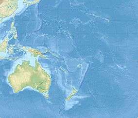 Ball's Pyramid Location on a map of Oceania | |
| Location | Australia |
| Parent range | Lord Howe Island Group |
| Geology | |
| Age of rock | less than 7 million years |
| Mountain type | Volcanic plug |
| Volcanic arc/belt | Lord Howe seamount chain |
| Last eruption | Unknown |
| Climbing | |
| First ascent | 1965 |
Ball's Pyramid is an erosional remnant of a shield volcano and caldera that formed about 6.4 million years ago.[1] It lies 20 kilometres (12 mi) southeast of Lord Howe Island in the Pacific Ocean. It is 562 metres (1,844 ft) high, while measuring only 1,100 metres (3,600 ft) in length and 300 metres (980 ft) across, making it the tallest volcanic stack in the world.[2] Ball's Pyramid is part of the Lord Howe Island Marine Park in Australia.
History
Discovery

The pyramid is named after Lieutenant Henry Lidgbird Ball, who reported discovering it in 1788. On the same voyage, Ball also reported discovering Lord Howe Island.
In The Voyage Of Governor Phillip To Botany Bay With An Account Of The Establishment Of The Colonies Of Port Jackson And Norfolk Island (1789), Arthur Phillip gives this description of the area around Ball's Pyramid, before describing Lord Howe Island:
There lies about four miles from the south-west part of the pyramid, a dangerous rock, which shows itself a little above the surface of the water, and appears not to be larger than a boat. Lieutenant Ball had no opportunity of examining whether there is a safe passage between them or not.[3]
The first person to go ashore is believed to have been Henry Wilkinson, a geologist at the New South Wales Department of Mines, in 1882.
Climbing
In 1964 a Sydney team, which included adventurer Dick Smith and other members of the Scouting movement, attempted to climb to the summit of the pyramid; however, they were forced to turn back on the fifth day as they ran short of food and water.
The first successful climb to the summit was made on 14 February 1965 by a team of climbers from the Sydney Rock Climbing Club, consisting of Bryden Allen, John Davis, Jack Pettigrew and David Witham.[4]
In 1979, Smith returned to the pyramid, together with climbers John Worrall and Hugh Ward. They successfully reached the summit and unfurled a flag of New South Wales provided to them by Premier Neville Wran, declaring the island Australian territory (a formality which it seems had not previously been done).
Climbing was banned in 1982 under amendments to the Lord Howe Island Act, and in 1986, all access to the island was banned by the Lord Howe Island Board. In 1990, the policy was relaxed to allow some climbing under strict conditions, which in recent years has required an application to the relevant state minister.[5]
Geography
.jpg)
Like Lord Howe Island and the Lord Howe seamount chain, Ball's Pyramid is based on the Lord Howe Rise, part of the submerged continent of Zealandia.
Ball's Pyramid has a few satellite islets. Observatory Rock and Wheatsheaf Islet lie about 800 metres (2,600 ft) west-northwest and west-southwest respectively, of the western extremity of Ball's Pyramid. Southeast Rock is a pinnacle located about 3.5 kilometres (2.2 mi) southeast of Ball's Pyramid.
Ball's Pyramid is positioned in the centre of a submarine shelf.[1] The shelf is 20 kilometres (12 mi) in length and averages 10 kilometres (6.2 mi) in width and lies under an average depth of 50 metres (160 ft) of water.[1] It is separated by a 500 metres (1,600 ft) deep submarine canyon from another shelf on which Lord Howe Island is located. The cliffs of the stack continue under the water surface to the level of the shelf.
Biodiversity
Melaleuca howeana
A Melaleuca howeana shrub was found growing on Ball's Pyramid. The bush was growing in a small crevice where water was seeping through cracks in the underlying rocks. This moisture supported relatively lush plant growth which had, over time, resulted in a buildup of plant debris several metres deep.
Dryococelus australis
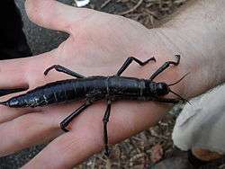
Ball's Pyramid supports the last known wild population of Lord Howe Island stick insect (Dryococelus australis).[6]
Following the last sighting of the Lord Howe Island stick insect on Lord Howe Island in 1920, the species was presumed extinct. Evidence of continued survival on Ball's Pyramid was discovered during the 1964 climb, when a dead specimen was found and photographed. Throughout the following years, several more dead specimens were discovered, but attempts to find live specimens were unsuccessful. In 2001, a team of entomologists and conservationists landed on Ball's Pyramid to chart its flora and fauna. As they had hoped, they discovered a population of the Lord Howe Island stick insect living in an area of 6 by 30 metres (20 by 100 ft), at a height of 100 metres (330 ft) above the shoreline, under a single Melaleuca howeana shrub. The population was extremely small, with only 24 individuals. Two pairs were brought to mainland Australia, and new populations have been successfully bred[7] with the ultimate goal of reintroduction to Lord Howe Island.
See also
References
- 1 2 3 Woodroffe, Colin (29 May 2012). "Balls Pyramid and the efficacy of marine abrasion". Vignettes. Carleton College. Retrieved 9 July 2013.
- ↑ Geography and Geology, Lord Howe Island Tourism Association. Retrieved on 2009-04-20.
- ↑ Philip, Arthur (1789). "The Voyage Of Governor Phillip To Botany Bay With An Account Of The Establishment Of The Colonies Of Port Jackson And Norfolk Island". Piccadilly, London: John Stockdale. Retrieved 9 April 2014.
- ↑ Jack Pettigrew's climbing page, including reproduced Sydney Morning Herald front page
- ↑ Mr Andrew Fraser (Coffs Harbour) in the New South Wales Legislative Assembly, 1 May 1996
- ↑ Krulwich, Robert (29 February 2012). "Six Legged Giant Finds Secret Hideaway for 80 years". National Public Radio. Retrieved 18 January 2016.
- ↑ Thomas, Abbie (14 February 2001). "Giant stick insect rediscovered". Australian Broadcasting Corporation.
Further reading
- Hutton, Ian (1998). The Australian Geographic Book of Lord Howe Island. Australian Geographic. ISBN 1-876276-27-4.
- Rock of Ages, transcript of Australian Broadcasting Corporation Australian Story TV episode, 11 April 2005.
External links
| Wikimedia Commons has media related to Ball's Pyramid. |
- Lord Howe Island Marine Park
- Lord Howe Island and Ball's Pyramid Nautical Chart issued by the Australian Hydrographic Service
- World Mountain Encyclopedia - Ball's Pyramid
- Volcano World - Balls Pyramid
- Mountaineering exploits: Ball's Pyramid. Bryden Allen.