Ballindine
| Ballindine Baile an Daighin | |
|---|---|
| Town | |
 | |
 Ballindine Location in Ireland | |
| Coordinates: 53°40′00″N 8°57′18″W / 53.6667°N 8.9550°WCoordinates: 53°40′00″N 8°57′18″W / 53.6667°N 8.9550°W | |
| Country | Ireland |
| Province | Connacht |
| County | County Mayo |
| Elevation | 96 m (315 ft) |
| Population (2011) | |
| • Urban | 350 |
| • Rural | 814 |
| Time zone | WET (UTC+0) |
| • Summer (DST) | IST (WEST) (UTC-1) |
| Irish Grid Reference | M369689 |
Ballindine (Irish: Baile an Daighin, meaning "Town of the Fortress") is a village in County Mayo, Ireland. It is located along the Western Railway Corridor, 6.5 km (4 miles) south of Claremorris. The N17 road passes through the village, carrying over 10,000 vehicles daily,[1] and it connects to the R328 road on the south side of town. The village will be bypassed as part of the Claremorris–Tuam dual-carriageway which is in the early stages of planning.[2]
Areas of interest
The remains of a possible fort are located in a field next to the National School. Folklore states that Ballindine got its name from this fort—Baile an Daingin meaning "Town of the Fortress" and that the souterrain, just outside it, was connected underground to the ruins of the old church in Cloonmore about 2 km (1.25 miles) to the east and also to the ruins of the old church in Garryduff, 5 km (3 miles) west.
Ballindine is in the Roman Catholic parish of Kilvine.Church records are held at the South Mayo Family Research Centre in Ballinrobe. Old school records dating to the 1800s are held in the present National School.
Local events
The village has had a monthly cattle and sheep fair since the 1960s and the Ballindine September fair was well known in West of Ireland. The July fair was also called 'The Gooseberry Fair' and Ballindine honoured this tradition with an annual 'Gooseberry Festival' until 2002.
Western Alzheimer's Foundation
The Western Alzheimer's Foundation which promotes awareness of the disease is headquartered in Ballindine.
Sport
The Ballindine Gaelic footballers join with Irishtown to form the Davitts team who play in red and black. Davitts is currently playing in Division 1A league and Senior Championship. In 2011 Davitts won the Intermediate County Championship beating Burrishoole 0-14 to 0-12 in the final. They went on to win the Intermediate Connacht Championship defeating Padraig Pearses on a scorline of 1-13 to 0-08.
People
- Pat Rabbitte, former leader of the Labour Party was born in Woodstock, a townland near the village, and still owns a family home there.
- Sabina Coyne, actress and wife of the President of Ireland, Michael D. Higgins, is a native of Cloonrane,[3] a townland in County Galway[4] one kilometre south of Ballindine.
Transport
- Ballindine railway station was opened on 30 April 1894, and closed on 17 June 1963[5]
Pictures
-

Ballindine
-
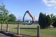
Outdoor sculpture in Ballindine
See also
References
- ↑ "Traffic Counter Data for "Tuam Road N17-15"". National Roads Authority. Retrieved 4 February 2012.
- ↑ "N17 Tuam to Claremorris". National Roads Authority. Retrieved 4 February 2012.
- ↑ Mayo well represented at presidential inauguration The Western People, 2011-11-16.
- ↑ Cloonrane Placenames Database of Ireland. retrieved: 2011-12-29.
- ↑ "Ballindine station" (PDF). Railscot - Irish Railways. Archived (PDF) from the original on 26 September 2007. Retrieved 2007-09-10.