Baldwin, Florida
| Baldwin | |
|---|---|
| Town | |
| Baldwin, Florida | |
|
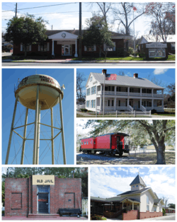
From top, left to right: Baldwin City Hall, Water tower, William Coleman House, Larry M. Carroll Memorial Park, Old Jail, First Baptist Church | |
 Location in Duval County and the state of Florida | |
| Coordinates: 30°18′14″N 81°58′30″W / 30.30389°N 81.97500°WCoordinates: 30°18′14″N 81°58′30″W / 30.30389°N 81.97500°W | |
| Country | United States |
| State | Florida |
| County | Duval |
| Area | |
| • Total | 2.0 sq mi (5.3 km2) |
| • Land | 2.0 sq mi (5.3 km2) |
| • Water | 0 sq mi (0 km2) |
| Elevation | 85 ft (26 m) |
| Population (2010)[1] | |
| • Total | 1,425 |
| • Estimate (2013)[2] | 1,430 |
| • Density | 702/sq mi (271.0/km2) |
| Time zone | Eastern (EST) (UTC-5) |
| • Summer (DST) | EDT (UTC-4) |
| ZIP code | 32234 |
| Area code(s) | 904 |
| FIPS code | 12-03250 |
| GNIS feature ID | 0278061[3] |
| Website | Town of Baldwin |
Baldwin is a town in Duval County, Florida, United States. When the majority of communities in Duval County consolidated with the city of Jacksonville in 1968, Baldwin, along with Jacksonville Beach, Atlantic Beach, and Neptune Beach, Florida, remained quasi-independent. Like the other towns, it maintains its own municipal government, but its residents vote in the Jacksonville mayoral election and vote for the Jacksonville City Council; unlike the others, Baldwin no longer supports its own police force. The population was 1,425 at the 2010 census.[4]
History
The town was first settled under the name of Thigpen in 1846. Mr. Thigpen had opened a tavern to benefit the stagecoach line at the crossroads of what is today Baldwin. He supplied horses for the stage and shelter and food for the passengers. The first railroad was built in Thigpen in 1857 with a second crossing it in 1859.[5] The name was changed to Baldwin in honor of Dr. Abel Seymour Baldwin, the president of the Florida, Atlantic and Gulf Central Railroad, a railroad that ran from Lake City to Jacksonville. Further development in Baldwin led to the establishment of a telegraphic line running from Jacksonville to Baldwin.

On August 10, 1864 during the Civil War a skirmish occurred between a Confederate cavalry and the 102nd Regiment United States Colored Troops. A section of railroad tracks were destroyed by the Federal troops. Two days later the Federals dispatched cavalry troops from Baldwin to drive Confederate forces back. One Federal soldier was killed and four were captured in the process.[6] Baldwin was then burned down by the Federals. From 1865 to 1875 Baldwin was rebuilt reaching a population of 250.
In 1947, the original school building serving the white population burned to the ground. There was no fire department to control it, and it was completely destroyed. The students from the school were temporarily housed in a variety of public buildings, including churches and the city hall. Later, barracks buildings from nearby army training base Camp Blanding were moved to the site of the burned school, where classes continued for about two years while a new school was being built. A school for the black population was located in a building located near the old ice plant that served the railroad. The school was occupied for a number of years after the new white school was built.
Florida State Law in 1948 required new school buildings be placed on parcels not less than 10 acres (40,000 m2) in size. As the property under the existing school was not large enough, a site on Mill Street was chosen. A $50,000 school was erected during the winter and summers of 1948 and 1949. In 1950, an auditorium was completed. At that time the school enrollment was 365. In 1964, a Music Suite was added.
In 1965 Baldwin became the first Duval County school to be integrated.
Geography
Baldwin is located at 30°18′14″N 81°58′30″W / 30.30389°N 81.97500°W (30.303788, -81.975029).[7]
According to the United States Census Bureau, the town has a total area of 2.0 square miles (5.3 km2), all land.[4]
Demographics
| Historical population | |||
|---|---|---|---|
| Census | Pop. | %± | |
| 1920 | 470 | — | |
| 1930 | 749 | 59.4% | |
| 1940 | 1,002 | 33.8% | |
| 1950 | 1,048 | 4.6% | |
| 1960 | 1,272 | 21.4% | |
| 1970 | 1,408 | 10.7% | |
| 1980 | 1,526 | 8.4% | |
| 1990 | 1,450 | −5.0% | |
| 2000 | 1,634 | 12.7% | |
| 2010 | 1,425 | −12.8% | |
| Est. 2015 | 1,453 | [8] | 2.0% |
| U.S. Decennial Census[9] 2013 Estimate[2] | |||
As of the census of 2000, there were 1,634 people, 628 households, and 432 families residing in the town. The population density was 767.3 inhabitants per square mile (296.2/km²). There were 702 housing units at an average density of 329.6 per square mile (127.3/km²). The racial makeup of the town was 67.07% White, 30.91% African American, 0.18% Native American, 0.86% Asian, 0.06% Pacific Islander, 0.06% from other races, and 0.86% from two or more races. Hispanic or Latino of any race were 0.80% of the population.
There were 628 households, out of which 35.2% had children under the age of 18 living with them, 41.2% were married couples living together, 22.5% had a female householder with no husband present, and 31.2% were non-families. 27.5% of all households were made up of individuals and 8.6% had someone living alone who was 65 years of age or older. The average household size was 2.60 and the average family size was 3.16.
In the town the population was spread out with 29.3% under the age of 18, 10.2% from 18 to 24, 27.4% from 25 to 44, 22.3% from 45 to 64, and 10.7% who were 65 years of age or older. The median age was 34 years. For every 100 females there were 86.7 males. For every 100 females age 18 and over, there were 82.5 males.
The median income for a household in the town was $28,603, and the median income for a family was $31,023. Males had a median income of $28,350 versus $23,056 for females. The per capita income for the town was $13,560. About 17.6% of families and 17.7% of the population were below the poverty line, including 24.8% of those under age 18 and 12.9% of those age 65 or over.
References
- ↑ "American FactFinder". United States Census Bureau. Retrieved 2014-09-10.
- 1 2 "Population Estimates". United States Census Bureau. Retrieved 2014-09-10.
- ↑ "US Board on Geographic Names". United States Geological Survey. 2007-10-25. Retrieved 2008-01-31.
- 1 2 "Geographic Identifiers: 2010 Demographic Profile Data (DP-1): Baldwin town, Florida". U.S. Census Bureau, American Factfinder. Retrieved March 25, 2013.
- ↑ "History of Baldwin". Town of Baldwin. Retrieved March 31, 2014.
- ↑ "August 1861-1865". Archived from the original on March 31, 2014. Retrieved March 20, 2014.
- ↑ "US Gazetteer files: 2010, 2000, and 1990". United States Census Bureau. 2011-02-12. Retrieved 2011-04-23.
- ↑ "Annual Estimates of the Resident Population for Incorporated Places: April 1, 2010 to July 1, 2015". Retrieved July 2, 2016.
- ↑ United States Census Bureau. "Census of Population and Housing". Archived from the original on May 11, 2015. Retrieved November 18, 2013.
External links
Municipalities and communities of Duval County, Florida, United States | ||
|---|---|---|
| Cities | 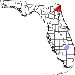 | |
| Town | ||