Baksa district
| Baksa district बक्सा जिला | |
|---|---|
| District | |
|
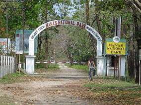
Gateway of Manas National Park at Baksa District | |
| Country |
|
| State | Bodoland |
| Headquarters | Mushalpur |
| Area | |
| • Total | 2,457 km2 (949 sq mi) |
| Population (2011) | |
| • Total | 950,075[1] |
| • Density | 387/km2 (1,000/sq mi) |
| Time zone | Indian Standard Time (UTC+5:30) |
| Website | Baksa.gov.in |
Baksa district (/ˈbʌksə/ or /ˈbæksə/; Bodo: बक्सा जिला ;Assamese: বাক্সা জিলা) is one of the 27 districts of Assam state under Bodoland Territorial Council in north-eastern India.
History
Baksa was notified as one of the districts of Bodoland Territorial Council in October 2003 while it started functioning from 1 June 2004[2] when Dr Anwaruddin Choudhury of the Assam Civil Service took charge as its founder Deputy Commissioner. It started working from PWD Inspection Bungalow of Barama on the NH 31 tll it was shifted to Mushalpur in late 2010.
It was created from parts of Barpeta, Nalbari, and Kamrup districts.[2]
Geography
Mushalpur town is the headquarters of the district. This district is bounded by Bhutan in the north, Udalguri district in the east, Barpeta, Nalbari and Kamrup districts in the south and Chirang district in the west. Area of the district is 2400 km².[3]
National protected area
- Manas National Park (Part)
Divisions
The district has three sub-divisions: Mushalpur, Salbari and Tamulpur. These sub-divisions are further divided into 13 revenue circles: Baksa, Barama, Tamulpur, Goreswar, Baganpara, Ghograpar, Barnagar, Bajali, Jalah, Patharighat, Rangia, Sarupeta and Tihu. Three Vidhan Sabha constituencies of this district are Tamulpur, Barama and Chapaguri. All of these are part of Kokrajhar Lok Sabha constituency.
Demographics
According to the 2011 census Baksa district has a population of 953,773,[4] roughly equal to the nation of Fiji[5] or the US state of Montana.[6] This gives it a ranking of 458th in India (out of a total of 640).[4] The district has a population density of 475 inhabitants per square kilometre (1,230/sq mi) .[4] Its population growth rate over the decade 2001-2011 was 11.17%.[4] Baksa has a sex ratio of 967 females for every 1000 males,[4] and a literacy rate of 70.53%.[4]
Major tribes
Baksa district is the home many tribal inhabitants like Bodo, Rabha, Sarania kachari and Madahi.
Educational Institutions
Major educational institutions of Baksa district are:
- B.B. Kishan College, Jalah
- Barama College
- Dhamdhama Junior College
- Goreswar College
- Mushalpur College
- Salbari Junior College
- ST. John's H.S. School, Barama
- Tamulpur College
Places of interest
Major part of the world famous Manas National Park is located in this district. The park is well known for its Wild Water Buffaloes and Golden Langurs.[7] Bogamati, a famous picnic spot with picturesque beauties is located in Baksa. Bhangtar is the other scenic location situated close to Bhutan border.
References
- ↑ http://www.censusindia.gov.in/2011census/dchb/1825_PART_B_DCHB_BAKSA.pdf
- 1 2 Law, Gwillim (2011-09-25). "Districts of India". Statoids. Retrieved 2011-10-11.
- ↑ Assam state website – Baksa district
- 1 2 3 4 5 6 "District Census 2011". Census2011.co.in. 2011. Retrieved 2011-09-30.
- ↑ US Directorate of Intelligence. "Country Comparison:Population". Retrieved 2011-10-01.
Fiji 883,125 July 2011 est.
- ↑ "2010 Resident Population Data". U. S. Census Bureau. Archived from the original on 2013-10-19. Retrieved 2011-09-30.
Montana 989,415
- ↑ Gee, E.P. (1964). The Wild Life of India. Collins, London.
External links
 |
|
| ||
| Chirang district | |
Udalguri district | ||
| ||||
| | ||||
| Barpeta district | Nalbari district | Kamrup district |
| Topics | |
|---|---|
| History | |
| Districts & Divisions |
|
| Geography | |
| Culture | |
| Arts, Literature, Music Cinema |
|
| People | |
| Notable surnames |
|
| Urban centres | |
| |
Coordinates: 26°34′51″N 91°25′13″E / 26.58083°N 91.42028°E