Gjetingsdalen
| Gjetingsdalen | |
|---|---|
| Village | |
|
View of the village area | |
 Gjetingsdalen  Gjetingsdalen Location in Hordaland county | |
| Coordinates: 60°08′11″N 06°14′11″E / 60.13639°N 6.23639°ECoordinates: 60°08′11″N 06°14′11″E / 60.13639°N 6.23639°E | |
| Country | Norway |
| Region | Western Norway |
| County | Hordaland |
| District | Sunnhordland |
| Municipality | Kvinnherad |
| Elevation[1] | 166 m (545 ft) |
| Time zone | CET (UTC+01:00) |
| • Summer (DST) | CEST (UTC+02:00) |
| Post Code | 5476 Mauranger |
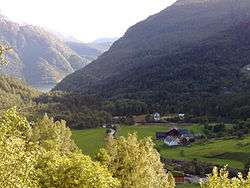
Gjetingsdalen is a village in the Mauranger area of Kvinnherad municipality in Hordaland county, Norway. The village is located in the Gjetingsdalen valley, on a hillside overlooking the Maurangsfjorden. The village of Austrepollen lies about 5 kilometres (3.1 mi) to the east, across the fjord. There is only one road leading into and out of the village (from Nordrepollen), making it rather isolated, but its close proximity to the Jondal Tunnel and Folgefonna Tunnel, give it good access to nearby urban areas. There is a hydroelectric power plant located along the river which runs through this valley.
The village is made up of several small farms. The Bakka farm is located in the top of the valley and it has great grazing pastures. This farm has about 36 head of cattle, giving it the highest milk production in the village. This farm also has a tourist guesthouse called Bolebua. Other farms in the village area include Medhus, Bråtun, and Øyjorda.
References
- ↑ "Gjetingsdalen, Kvinnherad (Hordaland)" (in Norwegian). yr.no. Retrieved 2015-03-20.