Baker River (New Hampshire)
Coordinates: 43°45′50″N 71°41′10″W / 43.7638°N 71.6860°W

The Baker River, or Asquamchumauke, is a 36.4-mile-long (58.6 km)[1] river in the White Mountains region of New Hampshire in the United States. It rises on the south side of Mount Moosilauke and runs south and east to empty into the Pemigewasset River in Plymouth. The river traverses the towns of Warren, Wentworth, and Rumney. It is part of the Merrimack River watershed.
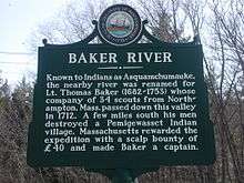
The Baker River's name recalls Lt. Thomas Baker (1682–1753), whose company of 34 scouts from Northampton, Massachusetts passed down the river's valley in 1712 and destroyed a Pemigewasset Indian village. It was along this river on April 28, 1752 that John Stark and Amos Eastman were captured by Abenaki warriors and taken to Saint-François-du-Lac, Quebec, near Montreal. John Stark's brother William Stark escaped, and David Stinson was killed during the ambush.
On the 1835 Thomas Bradford map of New Hampshire, the river is shown as "Bakers" River, originating on "Mooshillock Mtn."
Major tributaries
Tributaries greater than 5 miles (8.0 km) long, listed from upstream end to downstream end of Baker River:
- Berry Brook
- Pond Brook
- South Branch Baker River
- Halls Brook
- Stinson Brook
There is a large fish hatchery on the Baker River in the town of Warren.
References
- ↑ New Hampshire GRANIT state geographic information system Archived August 3, 2013, at the Wayback Machine.