Baiyun Mountain
| Baiyun Mountain | |
|---|---|
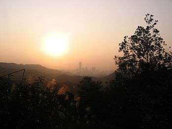 Baiyun with Zhujiang New Town in the distance | |
| Highest point | |
| Elevation | 382 m (1,253 ft) |
| Geography | |
| Location | Guangzhou, Guangdong, China |
| Climbing | |
| Easiest route | Cable Car |
| Baiyun Mountain | |||||||||||||
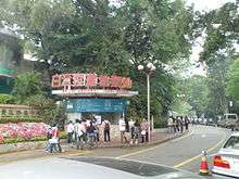
 Entrance to the Baiyun Scenic Area | |||||||||||||
| Simplified Chinese | 白云山 | ||||||||||||
|---|---|---|---|---|---|---|---|---|---|---|---|---|---|
| Traditional Chinese | 白雲山 | ||||||||||||
| Cantonese Jyutping | Baak6-wan4 Saan1 | ||||||||||||
| Cantonese Yale | Baahkwàhn Sāan | ||||||||||||
| Hanyu Pinyin | Báiyúnshān | ||||||||||||
| Postal | Pakwan Mountain | ||||||||||||
| Literal meaning | White Cloud Mountain | ||||||||||||
| |||||||||||||
| Alternative Chinese name | |||||||||||||
| Simplified Chinese | 云山 | ||||||||||||
| Traditional Chinese | 雲山 | ||||||||||||
| Cantonese Jyutping | Wan4-saan1 | ||||||||||||
| Cantonese Yale | Wàhnsāan | ||||||||||||
| Hanyu Pinyin | Yúnshān | ||||||||||||
| Literal meaning | Cloudy Mountain | ||||||||||||
| |||||||||||||
Baiyun Mountain, formerly romanized as Pakwan, is a mountain range in Guangzhou, the capital of China's Guangdong Province. It is organized as the Baiyun Scenic Area and is the site of Luhu Park, Yuntai Garden, Mingchun Valley, Moxing Peak, Mingzhu Tower, Yunxi Ecological Park, and the Baiyun Sculpture Park.
Name
Báiyún is Mandarin Chinese for "White Clouds", derived from views of the mountain's peaks shrouded in mist during late Spring or after a rain.[1] Its former English name, Pakwan, is a form of the Cantonese pronunciation of the same name. In English, it is also known as White Cloud Mountain, Mount Baiyun, Baiyun Shan, or—since the "mountain" is, properly speaking, a "mountain range"—the "Baiyun Mountains".
Baiyun is informally known as the "City's Lung" (市肺), from its greenery. It is also acclaimed as the "First Beauty in Guangzhou” (羊城第一秀)[1] or the “Most Famous Mountain South of Ling” (岭南第一名山).[2] Moxing Peak, its highest point, is similarly sometimes called the “First Peak under the Southern Sky” (天南第一峰).[1]
Geography
Baiyun is a mountain range located 15 kilometers (9 mi) north of central Guangzhou, made up of about 30 peaks, with an area of 28 km2 (11 sq mi). It is forms the southern end of the Dayu Mountains (大庾岭), themselves part of the Nanling Mountains (南岭山脉).[2] Baiyun's highest point is Moxing Peak (摩星岭, lit. “Star-scraping Peak”) at 382 meters (1,253 ft) above sea level. Vegetation covers over 95% of the area of Baiyun Mountain, enabling it to absorb 2800 tons of carbon dioxide and release 2100 tons of oxygen each day.
History
| Scenes on Baiyun Mountain named in Eight Sights of Guangzhou | ||
|---|---|---|
| Time | Chinese | English |
| Song Dynasty | 蒲涧帘泉 | Lianquan Fountain at Cattail Gully |
| Yuan Dynasty | 蒲间濂泉 | |
| 白云晚望 | Evening Vista from Baiyun | |
| 景泰僧归 | Jingtai's Returning Monks | |
| 1963 | 白云松涛 | Baiyun's Pine Sea |
| 1986 | 云山锦绣 | Cloudy Mountain's Grandeur |
| 2002 | 云山叠翠 | Cloudy Mountain's Lush Greenery |
| 2011 | 云山叠翠 | Cloudy Mountain, Green and Tidy |
Baiyun Mountain has been famed as a scenic spot since ancient times.[1] Its visitors predated the foundation of Panyu (now Guangzhou) in 214 BC, with various celebrities of the Warring States period (5th–3rd centuries BC) known to have traveled there. Its beauty was again celebrated during the 3rd–5th century Jin Dynasty and the 7th–9th century Tang.[3] Since the Song, various scenes at Baiyun have been named among the Eight Sights of Ram City, lists of Guangzhou's loveliest spots.[3][4][2] However, few of the historical sites have survived to the present day[1] and others—such as the view of Guangzhou's old walled city at dusk—have changed drastically as the city has expanded to and around the mountain.
Scenery
The Baiyun Scenic Area currently has six developed sightseeing zones: Mingzhu Tower; Mingchun Valley; Luhu Lake; and Moxing, Santai, and Fei'e Peaks. Older sites like the Village Hostel, Songtao Villa, Luming Restaurant, and the Baiyun Immortal’s House have been joined in the last ten years by the Baiyun Cableway, Mingchun Valley (Asia's largest birdcage), Guangzhou's Forest of Steles, Nengren Temple, Xinghai and Yuntai Gardens, the Baiyun Sculpture Park, and a golf course.
-

Suoai Tai
-

The entrance to Moxing Peak
-
A sculpture on Moxing Peak
-

China Mobile's telecom tower
-

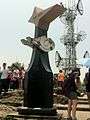
The Beautiful Southern Sky (锦绣南天, Jinxiu Nantian) Memorial Arch
Wildlife
The White Cloud Mountain minnow, now a popular aquarium fish worldwide, was discovered in this area in the 1930s.[5]
Transportation
There are various ways to get to Baiyun. It can be reached by taking buses 11, 24,[6] or 36, as well as dedicated routes leaving from Yuhua[6] and Guangwei Road.
From the foot of the mountain east of Yuntai Garden, the Baiyun Cableway can be taken 198 meters (650 ft) up the mountain to Peak Park. The cableway was the first bicable ropeway in China and has 80 cars, each seating 6 passengers. The route passes the Cloudy and Pu Valleys, a barbecue zone, and Nengren Temple and provides a scenic view of Guangzhou itself.
References
- 1 2 3 4 5 "白云山简介 [Brief Introduction to Baiyun Mountain]", Baiyuan Scenic Area, retrieved 7 July 2010. (Chinese)
- 1 2 3 "新世纪羊城八景 [Ram City's Eight Sights in the New Century", Official site, Guangzhou Municipal People's Government, 10 June 2005, retrieved 7 July 2010. (Chinese)
- 1 2 "白云山风景名胜区 [Baiyun Mountain Scenic Area]", Guangzhou News, 1 September 2008, retrieved 7 July 2010. (Chinese) & (English)
- ↑ "历史上的羊城八景 [Ram City's Eight Sights in History]", Guangzhou Culture Bureau, retrieved 7 July 2010. (Chinese)
- ↑ "Rediscovering the Wild Population of White Cloud Mountain Minnows (Tanichthys albonubes)", Europe PMC, retrieved 12 March 2016.
- 1 2 "Baiyun Mountain", ?.
External links
| Wikimedia Commons has media related to Baiyun Mountain. |
| Administrative divisions |  | |
|---|---|---|
| Attractions |
| |
| Culture & Demographics | ||
| Higher Education | ||
| History | ||
| Sports Venues | ||
| Transport |
| |
Coordinates: 23°11′12″N 113°17′41″E / 23.186642°N 113.294749°E