Baikal–Amur Mainline

Baikal Amur Mainline | |||||||||||||||||||||||||||||||||||||||||||||||||||||||||||||||||||||||||||||||||||||||||||||||||||||||||||||||||||||||||||||||||||||||||||||||||||||||||||||||||||||||||||||||||||||||||||||||||||||||||||||||||||||||||||||||||||||||||||||||||||||||||||||||||||||||||||||||||||||||||||||||||||||||||||||||||||||||||||||||||||||||||||||||||||||||||||||||||||||||||||||||||||||||||||||||||||||||||||||||||||||||||||||||||||||||||||||||||||||||||||||||||||||||||||||||||||||||||||||||||||||||||||||||||||||||||||||||||||||||||||||||||||||||||||||||||||||||||||||||||||||||||||||||||||||||||||||||||||||||||||||||||||||||||||||||||||||||||||||||||||||||||||||||||||||||||||||||||||||||||||||||||||||||||||||||||||||||||||||||||||||||||||||||||||||||||||||||||||||||||||||||||||||||||||||||||||||||||||||||||||||||||||||||||||||||||||||||||||||||||||||||||||||||||||||||||||||||||||||||||||||||||||||||||||||||||||||||||||||||||||||||||||||||||||||||||||||||||||||||||||||||||||||||||||||||||||||||||||||||
|---|---|---|---|---|---|---|---|---|---|---|---|---|---|---|---|---|---|---|---|---|---|---|---|---|---|---|---|---|---|---|---|---|---|---|---|---|---|---|---|---|---|---|---|---|---|---|---|---|---|---|---|---|---|---|---|---|---|---|---|---|---|---|---|---|---|---|---|---|---|---|---|---|---|---|---|---|---|---|---|---|---|---|---|---|---|---|---|---|---|---|---|---|---|---|---|---|---|---|---|---|---|---|---|---|---|---|---|---|---|---|---|---|---|---|---|---|---|---|---|---|---|---|---|---|---|---|---|---|---|---|---|---|---|---|---|---|---|---|---|---|---|---|---|---|---|---|---|---|---|---|---|---|---|---|---|---|---|---|---|---|---|---|---|---|---|---|---|---|---|---|---|---|---|---|---|---|---|---|---|---|---|---|---|---|---|---|---|---|---|---|---|---|---|---|---|---|---|---|---|---|---|---|---|---|---|---|---|---|---|---|---|---|---|---|---|---|---|---|---|---|---|---|---|---|---|---|---|---|---|---|---|---|---|---|---|---|---|---|---|---|---|---|---|---|---|---|---|---|---|---|---|---|---|---|---|---|---|---|---|---|---|---|---|---|---|---|---|---|---|---|---|---|---|---|---|---|---|---|---|---|---|---|---|---|---|---|---|---|---|---|---|---|---|---|---|---|---|---|---|---|---|---|---|---|---|---|---|---|---|---|---|---|---|---|---|---|---|---|---|---|---|---|---|---|---|---|---|---|---|---|---|---|---|---|---|---|---|---|---|---|---|---|---|---|---|---|---|---|---|---|---|---|---|---|---|---|---|---|---|---|---|---|---|---|---|---|---|---|---|---|---|---|---|---|---|---|---|---|---|---|---|---|---|---|---|---|---|---|---|---|---|---|---|---|---|---|---|---|---|---|---|---|---|---|---|---|---|---|---|---|---|---|---|---|---|---|---|---|---|---|---|---|---|---|---|---|---|---|---|---|---|---|---|---|---|---|---|---|---|---|---|---|---|---|---|---|---|---|---|---|---|---|---|---|---|---|---|---|---|---|---|---|---|---|---|---|---|---|---|---|---|---|---|---|---|---|---|---|---|---|---|---|---|---|---|---|---|---|---|---|---|---|---|---|---|---|---|---|---|---|---|---|---|---|---|---|---|---|---|---|---|---|---|---|---|---|---|---|---|---|---|---|---|---|---|---|---|---|---|---|---|---|---|---|---|---|---|---|---|---|---|---|---|---|---|---|---|---|---|---|---|---|---|---|---|---|---|---|---|---|---|---|---|---|---|---|---|---|---|---|---|---|---|---|---|---|---|---|---|---|---|---|---|---|---|---|---|---|---|---|---|---|---|---|---|---|---|---|---|---|---|---|---|---|---|---|---|---|---|---|---|---|---|---|---|---|---|---|---|---|---|---|---|---|---|---|---|---|---|---|---|---|---|---|---|---|---|---|---|---|---|---|---|---|---|---|---|---|---|---|---|---|---|---|---|---|---|---|---|---|---|---|---|---|---|---|---|---|---|---|---|---|---|---|---|---|---|---|---|---|---|---|---|---|---|---|---|---|---|---|---|---|---|---|---|---|---|---|---|---|---|---|---|---|---|---|---|---|---|---|---|---|---|---|---|---|---|---|---|---|---|---|---|---|---|---|---|---|---|---|---|---|---|---|---|---|---|---|---|---|---|---|---|---|---|---|---|---|---|---|---|---|---|---|---|---|---|---|---|---|---|---|---|---|---|---|---|---|---|---|---|---|---|---|---|---|---|---|---|---|---|---|---|---|---|---|---|---|---|---|---|---|---|---|---|---|---|---|---|---|---|---|---|---|---|---|---|---|---|---|---|---|---|---|---|---|---|---|---|---|---|---|---|---|---|---|---|---|---|---|---|---|---|---|---|---|---|---|---|---|---|---|---|---|---|---|---|---|---|---|---|---|---|---|---|---|---|---|---|---|---|---|---|---|---|---|---|---|---|---|---|---|---|---|---|---|---|---|---|---|---|---|---|---|---|---|---|---|---|---|---|---|---|---|---|---|---|---|---|---|---|---|---|---|---|---|---|---|---|---|---|---|---|---|---|---|---|---|---|---|---|---|---|---|---|---|---|---|---|---|---|---|---|---|---|---|---|---|---|---|---|---|---|---|---|---|---|---|---|---|---|---|---|---|---|---|---|---|---|---|---|---|---|---|---|---|---|---|---|---|---|---|---|---|---|---|---|---|---|---|---|---|---|---|---|---|---|---|---|---|---|---|---|---|---|---|---|---|---|
Legend
| |||||||||||||||||||||||||||||||||||||||||||||||||||||||||||||||||||||||||||||||||||||||||||||||||||||||||||||||||||||||||||||||||||||||||||||||||||||||||||||||||||||||||||||||||||||||||||||||||||||||||||||||||||||||||||||||||||||||||||||||||||||||||||||||||||||||||||||||||||||||||||||||||||||||||||||||||||||||||||||||||||||||||||||||||||||||||||||||||||||||||||||||||||||||||||||||||||||||||||||||||||||||||||||||||||||||||||||||||||||||||||||||||||||||||||||||||||||||||||||||||||||||||||||||||||||||||||||||||||||||||||||||||||||||||||||||||||||||||||||||||||||||||||||||||||||||||||||||||||||||||||||||||||||||||||||||||||||||||||||||||||||||||||||||||||||||||||||||||||||||||||||||||||||||||||||||||||||||||||||||||||||||||||||||||||||||||||||||||||||||||||||||||||||||||||||||||||||||||||||||||||||||||||||||||||||||||||||||||||||||||||||||||||||||||||||||||||||||||||||||||||||||||||||||||||||||||||||||||||||||||||||||||||||||||||||||||||||||||||||||||||||||||||||||||||||||||||||||||||||||
The Baikal–Amur Mainline (Russian Байкало-Амурская магистраль (БАМ), Baikalo-Amurskaya magistral', BAM) is a 1,520 mm (4 ft 11 27⁄32 in) broad gauge railway line in Russia. Traversing Eastern Siberia and the Russian Far East, the 4,324 km (2,687 mi) long BAM runs about 610 to 770 km (380 to 480 miles) north of and parallel to the Trans-Siberian railway.
The BAM was built as a strategic alternative route to the Trans-Siberian Railway, especially along the vulnerable sections close to the border with China. The BAM's costs were estimated at $14 billion, and it was built with special, durable tracks since much of it was built over permafrost. Due to the severe terrain, weather, length and cost Soviet premier Leonid Brezhnev described BAM as "the construction project of the century."[1]
Route
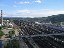
The BAM departs from the Trans-Siberian railway at Tayshet, then crosses the Angara River at Bratsk and the Lena River at Ust-Kut, proceeds past Severobaikalsk at the northern tip of Lake Baikal, past Tynda and Khani, crosses the Amur River at Komsomolsk-na-Amure and finally reaches the Pacific Ocean at Sovetskaya Gavan. There are 21 tunnels along the line, with a total length of 47 km (29 mi). There are also more than 4,200 bridges, with a total length of over 400 km (about 260 miles).[2]
Of the whole route, only the western Tayshet-Taksimo sector of 1,469 km (913 mi) is electrified. The route is largely single-track, although the reservation is wide enough for double-tracking for its full length, in the case of eventual duplication. The unusual thing about the railway is that it is electrified with a 27.5 kV, 50 Hz catenary minimum height at 6.5 metres above top of the rails to suit double-stacking under the overhead wires on the Russian gauge tracks, which requires rolling stock to be modified for service on the railway.
At Tynda the route is crossed by the Amur–Yakutsk Mainline, which runs north to Neryungri and Tommot, with an extension to Yakutsk opened in 2014, and now extension to Magadan under construction. The original section of the AYaM connecting the Trans-Siberian at Bamovskaya with the BAM at Tynda is also referred to as the "Little BAM".
During the winter the only passenger trains go from Moscow past Tayshet and Tynda towards Yakutsk. Travel time from Tayshet to Tynda is 48 hours.[3]
History
Early plans and start of construction
The route of the present-day BAM first came under consideration in the 1880s as an option for the eastern section of the planned Trans-Siberian railway.
In the 1930s labor-camp inmates, in particular from the Bamlag camp of the Gulag system, built the section from Tayshet to Bratsk. In a confusing transfer of names, the label BAM applied from 1933 to 1935 to the project to double-track the Trans-Siberian east of Lake Baikal, constructing largely using forced labor.[4]
1945 saw the finalisation of plans for upgrading the BAM for diesel or electric instead of steam traction, and for the heavier axle-loads of eight-axle oil tankers to carry new-found oil[5] from Western Siberia. The upgrading required 25 years and 3,000 surveyors and designers, although much of the redesign work (particularly as regards the central section) took place between 1967 and 1974.[4]
Construction project of the century
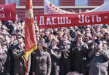
In March 1974, Soviet General Secretary Brezhnev proposed that the BAM would be one of the two major projects in the Tenth Five Year Plan (1976–80).[4] He famously stated that "BAM will be constructed with clean hands only!" and firmly rejected the suggestion to again use prison labor. A few weeks later he challenged the Young Communist League (Komsomol) to join in "the construction project of the century."[1] 17th Komsomol congress (held in April 1974) announced BAM a Komsomol shock construction project, created the central Komsomol headquarters of BAM construction, and appointed Dmitry Filippov the chief of the headquarters.
By the end of 1974 perhaps 50,000 young people of the 156,000 young people who applied had moved to the BAM service area. In 1975 and 1976 28 new settlements were inaugurated, and 70 new bridges including the Amur and Lena bridges were erected. And while 110 miles (180 km) of track was laid, the tracklaying rate would have needed to nearly triple to meet the 1983 deadline.[4]
In September 1984, a "golden spike" was hammered into place, connecting the eastern and western sections of the BAM. The Western media was not invited to attend this historic event as Soviet officials did not want any comments about the line's operational status. In reality, only one third of the BAM's track was fully operational for civilians, due to military reasons.[6]
The BAM was again declared complete in 1991. By then, the total cost to build the line was US$14 billion.
Crisis
Beginning in the mid-1980s, the BAM-project attracted increasing criticism for bad planning. Infrastructure and basic services like running water were often not in place when workers arrived. At least 60 boomtowns developed around the route, but nowadays a lot of these places are deserted ghost towns and unemployment in the area is high. The building of the BAM has also been criticised for its complete lack of environmental protection.[7]
When Soviet Union was dissolved, numerous mining and industrial projects in the region were cancelled, and the BAM was greatly underutilized until the late 1990s, running at a large operational deficit.
In 1996, the BAM as a single operational body was dissolved, with the western section from Tayshet to Khani becoming the East Siberian Railway, the rest transferred to the management of the Far Eastern Railway.
Current situation and future prospects
A major improvement was the opening of the 15,343-meter (9.534 mi) Severomuysky Tunnel on December 5, 2003. It is up to 1.5 kilometres (nearly 1 mile) deep. Construction took 27 years to complete. Prior to this, the corresponding route segment was 54 km (34 mi) long, with heavy slopes necessitating the use of auxiliary (helper) locomotives.
With the resources boom of recent years and improving economic conditions in Russia, use of the line is increasing. Plans exist for the development of mining areas such as Udokanskoye and Chineyskoye near Novaya Chara, as well as one of Eurasia's largest coal deposits at Elginskoye (Elga) in the Sakha Republic (Yakutia). In connection with this, a number of branch lines have been built or are under construction.
In January 2012 the Russian mining company Mechel completed the construction of the 320-kilometre-long branch line to Elginskoye, branching from the BAM station Ulak, west of the Zeya River crossing in northwestern Amur Oblast.[8][9] The branch line connects the Elginskoye coal mine to the Russian railroad network.
It is also intended that the BAM should become an alternative route for container transport between Europe and the Pacific, although the single-track nature of most of the route and the lack of suitable connections at the eastern end currently stand in the way. Currently under discussion is the construction of a bridge or tunnel under the Strait of Tartary to Sakhalin Island, with the possibility of the further construction of a bridge or tunnel from Sakhalin to Japan. A tunnel from the mainland to Sakhalin was previously begun under Joseph Stalin, but was abandoned after his death. A second attempt in 2003 was also postponed during construction. Current economic conditions make the short-term completion of the tunnel doubtful, although Russian president Dmitry Medvedev announced in November 2008 his support for a revival of this project.[10]
The BAM now also attracts the interest of Western railway enthusiasts, with some tourist activity on the line.[2]
Also, the BAM itself extension from Komsomolsk-on-Amur to Magadan (Okhotsk coastal route), full length electrification, full length track doubling, and double-stacking under the overhead wires on the Russian gauge tracks (with well cars to make 6.15m height) are proposed. The future BAM passenger rolling stocks which include:
- Bilevel carriages with low doors,
- Shinkansen-based Russian gauge EMUs with low doors,
- Talgo wide-bodyshell trainsets, and
- Talgo AVRIL Russian gauge trainsets.
Along the BAM

Tayshet to Lake Baikal 1064 km: 0: Tayshet: about 300 km east of Krasnoyarsk, Trans-Siberian Railway, M53 highway to Irkutsk. 129: Sosnovye Rodniki: timber port. Chuna River 142: Chuna. 269: Vikhorevka: railway administration. 282: Anzebi: 20 km spur line to Bratsk town. About 330: Bratsk Dam: Railway runs across the top of the dam. 463: Vidim. 546: Sredneilimskaya on the Ust-Ilimsk reservoir. 554: Zheleznogorsk-Ilimsky: mining town. 575: Khrebetovaya: branch line north to Ust-Ilimsk (see branches below); enter Lena basin. Kuta River. 715: Ust-Kut: port on the Lena River where goods are loaded onto boats for transport north. End of the line until 1974. 736: Lena Vostochnaya: east of the Lena, start of the BAM proper from 1974. Line tends east southeast. 786: Zvyozdnaya: first new town built on the BAM. 890: Kirenga: 12 km east is the larger town of Magistralnyy. Kirenga River and bridge. 931: Ul'kan: on the Ulkan branch of the Kirenga. 1005: Delbichenda: last stop before the 6.7 km Baikal Mountain Tunnel (between 1979 and 1984 there was a 15 km bypass over the mountain). 1014: Daben. 1064: Lake Baikal.[2]
Lake Baikal to Tynda 1300 km: 1064: Severobaykalsk. Four small tunnels along the lake. 1104: Nizhneangarsk; leave Lake Baikal, northeast up the valley of the Upper Angara River. 1257: Novy Uoyan: there is talk of building a railroad south from here to the Trans-Siberian. Enter Severomuysk Mountains. Much permafrost from here to Tynda. 1385–1400: Severomuysky Tunnel: 15.7 km long, very difficult construction. Exit mountain. Scenic section with mountains to north and south. Much fog. 1484: Taksimo: end of electrified section. Muya River. 1548: Shivery: leave Buryat Republic. Vitim River. 1577: Kuanda: official 'completion' of the BAM was celebrated here in September 1984. Valley into mountains. 1664: Kodar: Kodar mountains, 1.9 km tunnel. 1734: Novaya Chara. 1879: Khani: the only BAM town in the Sakha Republic. Northernmost point on the line. Line turns south-southeast along the Olyokma River. Enter Amur basin. 2364: Tynda.
Tynda to Komsomolsk 1473 km: 2364: Tynda: Branch railway and highway north to Yakutsk, little BAM south to the Trans-Siberian. 2704: Bridge over Zeya Reservoir. Line heads southeast. 3205: Bureya River bridge. 3315: Novy Urgal: Branch south to Trans-Siberian. 3403: east to Dusse-Alin Tunnel. Northeast up the Amgun River. 3633: Postyshevo: east. 3697: Evoron Lake. southeast to 3837: Komsomolsk-on-Amur.
Komsomolsk to Sovetskaya Gavan 486 km. This section was completed by prisoners during World War II, except for the 19 km section east of Komsomolsk which was completed in 1974. Komsomolsk. 1734m Amur River Bridge. 0: Pivan (new numbering system). 51: Selikhin: Branch. 95–340: Sikhote Alin Mountains. 403: Mongokhto 441: Vanino: port, train ferry to Sakhalin Island, practical end of passenger service. 467: Sovetskaya Gavan: naval base.
In April 2008 the state-owned Bamtonnelstroy corporation started work on the new 3.91 km single-track Kuznetsovsk tunnel to bypass an older tunnel built in 1943–1945.[11] It was opened in December 2012. The old tunnel had difficult gradients; building the new tunnel relieved a bottleneck on the BAM.[12] The 59.8 bn roubles (about $1.93 bn) project included 20 km of new track. In 2010, Yakunin had said, the stretch between Komsomolsk and Sovetskaya Gavan was the weakest link on the BAM, which, he said, could be carrying 100 million tons of freight a year in 2050.[13]
Branches
- 575: Khrebtovaya to Ust-Ilimsk, 214 km: Opened in 1970, it runs northeast to serve the Ust-Ilimsk Dam.
- 1257: Novy Uoyan: possible start of line south on east side to Lake Baikal.
- 2364: Tynda to the Trans-Siberian at Bamovskaya,180 km (the 'Little BAM'): This branch was built by prisoners in 1933–37, torn up in 1942 and its rails shipped to the front and rebuilt in 1972–75.
- 2364: Tynda to Yakutsk: see Amur–Yakutsk Mainline.
- 3315: Novy Urgal to the Trans-Siberian at Izvestovskaya,328 km: In the Bureya River basin, it was built mostly by Japanese POWs. There is a 32 km branch north from Novy Urgal to the Chegdomyn coal fields.
- 3837: Komsomolsk south to Khabarovsk, 374 km; on east side (flood plain) of the Amur. 99 km south: Lake Bolon.
- 51 (line km restart at Komsomolsk): Selikhin to Cherny Mys, 122 km: north along the Amur. Built 1950–53, it was planned to extend this to a tunnel to Sakhalin Island. There is talk of restarting it.
The BAM road
Running approximately alongside the railway track is the BAM road, a railway service track. It is said to be in a very poor state, with collapsed bridges, dangerous river crossings, severe potholes and "unrelenting energy-sapping bogs". The road is passable only by the most extreme off-road vehicles and adventure motorcycles. In 2009, a group of three experienced motorcycle riders took a whole month to travel from Komsomolsk (in the east) to Lake Baikal.[14][15]
Honors
Main belt asteroid 2031 BAM, discovered in 1969 by Soviet astronomer Lyudmila Chernykh, is named in honor of the builders of the BAM.[16]
Gallery
-
Railway station at Tynda
-
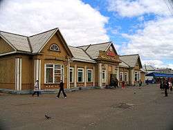
Railway station at Vikhorevka
-
Railway station at Fevralsk
-

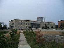
Old station building at Tayshet
References
- 1 2 Brown, Dale M. and Mann, Martin, editors. Library of Nations: The Soviet Union. 1985. Time Life Books. Alexandria, Virginia. ISBN 0-8094-5327-4
- 1 2 3 Yates, Athol & Zvegintzov, Nicholas Siberian BAM Guide: Rail, Rivers & Road (1995, 2nd edition 2001, Trailblazer Publications, England) ISBN 1-873756-18-6 (see excerpt)
- ↑ http://rzd.ru
- 1 2 3 4 Shabad, Theodore and Mote, Victor L: Gateway to Siberian Resources (The BAM) pp. 71–73 (Halstead Press/John Wiley, New York, 1977) ISBN 0-470-99040-6
- ↑ Compare:
Gaidar, Yegor (2010). Collapse of an Empire: Lessons for Modern Russia. Translated by Antonina W. Bouis. Brookings Institution Press. p. 100. ISBN 9780815731153. Retrieved 2015-12-05.
The first oil well in Western Siberia was opened in September 1953.73 Large-scale geological discoveries came in the period 1961-65 [...].
- ↑ Ward, C.J., 'Selling the "Project of the Century": Perceptions of the Baikal-Amur Mainline Railway (BAM) in the Soviet Press, 1974–1984', Canadian Slavonic Papers (2001), 75–95.
- ↑ Victor L. Mote, 'BAM after the fanfare: the unbearable ecumene', in: John M. Steward, (ed.), The Soviet environment: problems, policies and politics (Cambridge 1990), 40–54
- ↑
- ↑
- ↑ PrimaMedia: Президент России хочет остров Сахалин соединить с материком (Russian)
- ↑ Construction of the new Kuznetsovsky tunnel, Bamtonnelstroy press service, undated. Retrieved: 31 March 2011].
- ↑ "Kuznetsovsk tunnel shortens the BAM corridor". Railway Gazette International. Retrieved 2 February 2013.
- ↑ Freight volumes via BAM to reach 100m tons a year by 2050, Portnews.ru, St Petersburg, 24 March, 2010. Retrieved: 31 March 2011].
- ↑ "MCN Adventure" August 2011
- ↑ http://www.advrider.com/forums/showthread.php?t=533442
- ↑ Schmadel, Lutz D. (2003). Dictionary of Minor Planet Names (5th ed.). New York: Springer Verlag. p. 164. ISBN 3-540-00238-3.
External links
| Wikimedia Commons has media related to Baikal Amur Mainline. |
-
 Baikal-Amur Mainline travel guide from Wikivoyage
 - Construction history of the BAM
- Private homepage about the BAM (section in English)
- BAM: Soviet construction project of a century
- BAM Guide on Trailblazer Publications website
- NYTimes 2012 travel feature