Mulegé Municipality
| Mulegé | ||
|---|---|---|
| Municipality | ||
| ||
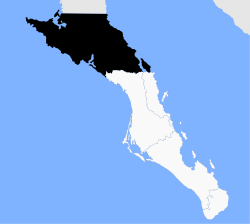 Location of Mulegé in Baja California Sur. | ||
| Country | Mexico | |
| State | Baja California Sur | |
| Municipal seat | Santa Rosalía | |
| Largest city | Guerrero Negro | |
| Area | ||
| • Total | 32,000.37 km2 (12,355.41 sq mi) | |
| Population (2015) | ||
| • Total | 60,171 | |
| • Density | 1.9/km2 (4.9/sq mi) | |
| Time zone | MST (UTC−7) | |
| • Summer (DST) | MDT (UTC−6) | |

Mulegé is the northernmost municipality of the Mexican state of Baja California Sur. It is the second-largest (behind only Ensenada) municipality by area in the country, with an area of 32,092.2 km² (12,777 sq mi). In the census of 2010 it had a population of 59,114 inhabitants. Isla Natividad is part of the municipality.
The municipal seat is located in Santa Rosalía.
There is an initiative to split the municipality into two, with the division along the ridge dividing the current municipality, so that the Pacific side, which includes its largest city, Guerrero Negro, and also Villa Alberto Andrés Alvarado Arámburo, would be separated from the Gulf of California side, which includes Santa Rosalía and Mulegé.
Subdivisions
Including the municipal seat of Santa Rosalía, the municipality is subdivided into six delegaciones:
Demographics
| Historical population | ||
|---|---|---|
| Year | Pop. | ±% |
| 1970 | 19,416 | — |
| 1980 | 26,983 | +39.0% |
| 1990 | 38,528 | +42.8% |
| 1995 | 45,963 | +19.3% |
| 2000 | 45,989 | +0.1% |
| 2005 | 52,743 | +14.7% |
| 2010 | 59,114 | +12.1% |
| [1] | ||
As of 2010, the municipality had a total population of 59,114.[2]
The municipality had 979 localities, the largest of which (with 2010 populations in parentheses) were: Guerrero Negro (13,054), Santa Rosalía (11,765), Villa Alberto Andrés Alvarado Arámburo (6,902), Heroica Mulegé (3,821), Bahía Tortugas (2,671), classified as urban, and San Francisco (2,152), Las Margaritas (1,595), Bahía Asunción (1,484), and El Silencio (1,190), classified as rural.[2]
References
- ↑ http://www.inegi.org.mx/lib/olap/consulta/general_ver4/MDXQueryDatos.asp?#Regreso&c=17161
- 1 2 "Mulegé". Catálogo de Localidades. Secretaría de Desarrollo Social (SEDESOL). Retrieved 23 April 2014.
- 2010 census tables: INEGI: Instituto Nacional de Estadística, Geografia e Informática (INEGI)
- Los 20 Municipios Más Extensos Instituto Nacional Para el Federalismo y el Desarrollo Municipal
External links
| Wikimedia Commons has media related to Mulegé Municipality. |
La Paz (capital) | ||
| Municipalities and municipal seats | 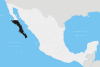 | |
Coordinates: 27°15′N 113°15′W / 27.250°N 113.250°W